Daru, Sierra Leone

Last updated
Daru
Sierra Leone adm location map.svg
Red pog.svg
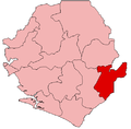
Daru
Location in Sierra Leone
Coordinates: 07°59′31″N10°50′26″W / 7.99194°N 10.84056°W / 7.99194; -10.84056
Country Flag of Sierra Leone.svg Sierra Leone
Province Eastern Province
District Kailahun
Chiefdom Jawei
Population
  Total5,958
 2010
Time zone UTC-5 (GMT)

Daru [1] is a town in Kailahun District in the Eastern Province of Sierra Leone with a population of 5,958 (2010 estimate) [2] Daru lies approximately 25 miles (40 kilometers) to Kenema

Contents

Daru is home to one of the largest military barracks in Sierra Leone. The vast majority of the people in the town are from the Mende ethnic group. Home of late Hon. Maigore Kallon, former chairman of SLPP, former member of Parliament and former minister of Foreign affairs in the Kabba administration. One of the sons of Daru, Jawie, Maigore Kallon Jr, is also a community health officer, graduated from Njala University, from the school of community health sciences.

Steady Bongo, one of the most popular Sierra Leonean musicians, was born and raised in Daru. Samuel Swarray a prominent clinical officer and a strong chiefdom development advocate is also an indigene of jawie.

The chiefdom is known for a unique culture, Goldtree ltd. Is a palm tree company that produces palmoil and palm kernel oil also located in the chiefdom, very close to Daru.

Transport

Daru was formerly the terminus of a now closed railway line from the capital.

Climate and vegetation

The community has a typical monsoon climate type which is the same as the Southeastern region of the country. It experiences longer period of rainy season and high amount of rainfall. The dry season normally starts at November and ends in March whist the rest is considered wet season. This makes the soil of the chiefdom or district very arable and fertile and allows the cultivation of many crops. It has a normal temperature of 26 °C and humility of 92%. Daru lies along the rain forest zone in the country.

The community was once surrounded with thick forested, but this forest had been replaced by palm-trees and farm bush over the years due to farming activities. Presently, the community is largely surrounded by palm-tree plantation owned by the Goldtree Plantation Ltd. Swamps and grassland comprised the remaining vegetation of the community.

Climate data for Daru
MonthJanFebMarAprMayJunJulAugSepOctNovDecYear
Average high °C (°F)31.4
(88.5)
33.8
(92.8)
33.9
(93.0)
33.2
(91.8)
32.5
(90.5)
31.0
(87.8)
28.9
(84.0)
28.3
(82.9)
30.0
(86.0)
31.0
(87.8)
31.1
(88.0)
30.6
(87.1)
31.3
(88.3)
Daily mean °C (°F)25.0
(77.0)
26.8
(80.2)
27.4
(81.3)
27.3
(81.1)
27.0
(80.6)
26.3
(79.3)
25.1
(77.2)
24.7
(76.5)
25.7
(78.3)
26.1
(79.0)
26.0
(78.8)
25.2
(77.4)
26.1
(78.9)
Average low °C (°F)15.3
(59.5)
19.9
(67.8)
21.0
(69.8)
21.5
(70.7)
21.6
(70.9)
21.6
(70.9)
21.3
(70.3)
21.2
(70.2)
21.4
(70.5)
21.2
(70.2)
21.0
(69.8)
19.9
(67.8)
20.6
(69.0)
Average rainfall mm (inches)12
(0.5)
34
(1.3)
91
(3.6)
163
(6.4)
241
(9.5)
301
(11.9)
333
(13.1)
377
(14.8)
391
(15.4)
324
(12.8)
173
(6.8)
42
(1.7)
2,482
(97.8)
Source: Climate-Data.org [3]

See also

Notes

  1. Daru (Approved) at GEOnet Names Server, United States National Geospatial-Intelligence Agency
  2. "Population of Daru".
  3. "Climate: Daru". Climate-Data.org. Retrieved August 5, 2020.


Related Research Articles

<span class="mw-page-title-main">Sierra Leone</span> Country on the southwest coast of West Africa

Sierra Leone, officially the Republic of Sierra Leone, is a country on the southwest coast of West Africa. It shares its southeastern border with Liberia, and the northern half of the nation is surrounded by Guinea. Covering a total area of 71,740 km2 (27,699 sq mi), Sierra Leone has a tropical climate, with diverse environments ranging from savanna to rainforests. The country has a population of 7,092,113 as of the 2015 census. Freetown is the capital and largest city. The country is divided into five administrative regions, which are subdivided into 16 districts.

<span class="mw-page-title-main">Montserrado County</span> County in Liberia

Montserrado County is a county in the northwestern portion of the West African nation of Liberia containing its national capital, Monrovia. One of 15 counties that comprise the first-level of administrative division in the nation, it has 17 sub political districts. As of the 2008 Census, it had a population of 1,118,241, making it the most populous county in Liberia. The area of the county measures 1,912.7 square kilometres (738.5 sq mi), the smallest in the country. Bensonville serves as the capital.

<span class="mw-page-title-main">Mende people</span> Ethnic group in Sierra Leone

The Mende are one of the two largest ethnic groups in Sierra Leone; their neighbours, the Temne people, constitute the largest ethnic group at 35.5% of the total population, which is slightly larger than the Mende at 31.2%. The Mende are predominantly found in the Southern Province and the Eastern Province. The Mende are mostly farmers and hunters. Some of the major cities with significant Mende populations include Bo, Kenema, Kailahun, and Moyamba.

<span class="mw-page-title-main">Kabala, Sierra Leone</span> Place in Northern Province, Sierra Leone

Kabala is the capital and largest town of Koinadugu District in the Northern Province of Sierra Leone. Kabala is one of the main towns in Northern Sierra Leone and is set in a rural landscape, surrounded by mountains.

<span class="mw-page-title-main">Kenema</span> Place in Eastern Province, Sierra Leone

Kenema is the third largest city in Sierra Leone, and the largest city in the country's Eastern Province. It is the capital of Kenema District and a major economic center of the Eastern Province. At the 2015 national census, Kenema had a population of 200,354. Kenema is located approximately 200 miles from Freetown, and 60 kilometres (40 mi) south of Bo.

<span class="mw-page-title-main">Gbarpolu County</span> County of Liberia

Gbarpolu is a county in the northern portion of Liberia. One of 15 counties that comprise the first-level of administrative division in the nation, it has six districts. Bopulu serves as the capital with the area of the county measuring 9,689 square kilometres (3,741 sq mi). As of the 2008 Census, it had a population of 83,758, making it the eleventh-most populous county in Liberia.

<span class="mw-page-title-main">Moyamba District</span> Place in Province, Sierra Leone

Moyamba District is a district in the Southern Province of Sierra Leone, with a population of 318,064 in the 2015 census. Its capital and largest city is Moyamba. The other major towns include Njala, Rotifunk and Shenge. The district is the largest in the Southern Province by geographical area, occupying a total area of 6,902 km2 (2,665 sq mi) and comprises fourteen chiefdoms.

<span class="mw-page-title-main">Akim Oda</span> Town in Eastern Region of Ghana

Akim Oda, a town in Ghana's Eastern Region, serves as the administrative and traditional center of the Birim Central Municipal District and Akyem Kotoku, respectively. The town had 60,604 residents as of 2013.

<span class="mw-page-title-main">Bombali District</span> Place in Northern Province, Sierra Leone

Bombali is a district in the Northern Province of Sierra Leone. Its capital and largest city is Makeni, which is also the largest city in the north. The Bombali district is one of the sixteen districts of Sierra Leone. Bombali is one of the largest districts in Sierra Leone by geographical area, after Koinadugu District, and is the second most populous district in the Northern part of Sierra Leone, after Port Loko district. In the 2015 Sierra Leone national census, the population of Bombali District was 606,183. Other major towns in Bombali District include Kamabai, Karina and Binkolo.

<span class="mw-page-title-main">Bonthe District</span> Place in Southern Province, Sierra Leone

Bonthe District is a district that comprises several islands and mainland of the Atlantic Ocean in the Southern Province of Sierra Leone. Bonthe is one of the sixteen districts of Sierra Leone. Its capital is the town of Bonthe Island and its largest city is Bonthe, on Sherbro Island. As of the 2015 census, the district had a population of 200,730. Bonthe District is one of the sixteen districts of Sierra Leone. Bonthe District is subdivided into eleven chiefdoms.

<span class="mw-page-title-main">Tonkolili District</span> Place in Northern Province, Sierra Leone

Tonkolili District is a district in the Northern Province of Sierra Leone. Its capital and largest city is Magburaka. The other major towns include Masingbi, Yele, Mile 91, Bumbuna, Yonibana, Matotoka. Mathora, Magbass and Masanga. Tonkolili District is home to the largest sugar factory in Sierra Leone, and one of the largest sugar factories in West Africa, that is located in the town of Magbass. Tonkolili District had a population of 530,776. The district occupies a total area of 7,003 km2 (2,704 sq mi) and comprises eleven chiefdoms.

<span class="mw-page-title-main">Limba people (Sierra Leone)</span> Ethnic group in Sierra Leone

The Limba people are an ethnic group in Sierra Leone. They represent 12.4% of the total population, making them the third largest ethnic group in Sierra Leone. The Limba are based in the north of the country across seven provinces, but are predominantly found in the Northern Province of Sierra Leone.

<span class="mw-page-title-main">Kambia District</span> Place in North West Province, Sierra Leone

Kambia District is a district in the North West Province of Sierra Leone. Its capital and largest city is the town of Kambia. As of the 2015 census, The District had a population of 343,686. Kambia District borders the Republic of Guinea to the north, Port Loko District to the south and Karene District to the east. The district provides an important Trade route to or from the Sierra Leonean capital Freetown to the Guinean capital Conakry.

<span class="mw-page-title-main">Kailahun District</span> Place in Eastern Province, Sierra Leone

Kailahun District is a district in the Eastern Province of Sierra Leone. Its capital and largest city is the town of Kailahun. The second most populous city in the district is Segbwema. Other major towns in Kailahun District include Koindu, Pendembu and Daru. As of the 2015 census, the district had a population of 525,372. Kailahun District is subdivided into fourteen chiefdoms.

<span class="mw-page-title-main">Kenema District</span> Place in Eastern Province, Sierra Leone

Kenema District is a district in the Eastern Province of Sierra Leone. Its capital and largest city is Kenema, which is the third most populous city in Sierra Leone, after Freetown and Bo. Tongo is the second most populous city in the district. Other major towns in Kenema District include Blama and Yomboma. The district is the most populous district in the Eastern province with a population 609,873. Kenema District has an area of 6,053 km2 (2,337 sq mi) and comprises sixteen chiefdoms.

Segbwema is a town in Kailahun District in the Eastern Province of Sierra Leone. The town is a major business and agricultural centre. Segbwema lies approximately 20 miles northeast of Kenema and about 225 miles south-east of Freetown. The population of Segbwema was 7,961 in the 2004 census with a current estimate of 16,532.

Mattru Jong commonly known as Mattru is the capital of Bonthe District in the Southern Province of Sierra Leone. Mattru Jung is located on the mainland of Bonthe District, along the Jong River, 52 miles southwest of Bo. The town is the seat of Mongerewa Jong Chiefdom, and is the home of Mongerewa Jong Paramount Chief Alie Badara Sheriff III. The town's current estimated population is about 20,000 people. In 2010 it was 8,199, and in the 2004 census the town had a population of 7,647.

Jawei Chiefdom is a chiefdom in Kailahun District of Sierra Leone with a population of 42,635. Its largest town and headquarters is Daru.

Maigore Kallon was a Sierra Leonean politician and diplomat. A founding member of the Sierra Leone People's Party (SLPP), he later served as the chairman of the party. Kallon served as the third Minister of Foreign Affairs and International Cooperation of Sierra Leone from 1965 to 1967. He briefly regained the position of Foreign Minister in 1996 during the first cabinet of President Ahmad Tejan Kabbah, a member of the SLPP.

Bagbo Chiefdom is a chiefdom in Bo District of Sierra Leone. Its capital is Jimmi.