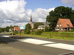
De Krim | |
---|---|
Location in province of Overijssel in the Netherlands | |
Coordinates: 52°38′55″N6°37′06″E / 52.6487°N 6.6183°E | |
Country | Netherlands |
Province | Overijssel |
Municipality | Hardenberg |
Area | |
• Total | 19.09 km2 (7.37 sq mi) |
Elevation | 10 m (30 ft) |
Population (2021) [1] | |
• Total | 2,190 |
• Density | 110/km2 (300/sq mi) |
Time zone | UTC+1 (CET) |
• Summer (DST) | UTC+2 (CEST) |
Postal code | 7781 & 7782 [1] |
Dialing code | 0524 |
De Krim is a village in the municipality of Hardenberg part of the province of Overijssel, Netherlands. The village started as a peat excavation village.
In 1832, the Lutterhoofdwijk canal was dug as a side canal of the Dedemsvaart to excavate the peat in the area, and a settlement developed along the canal. [3]
On 17 October 1857, it was first mentioned as De Krim (Dutch for Crimea). [4] That year, there was a riot among the peat workers which was suppressed by the Royal Marechaussee; the heavy-handedness of the police action was compared to the Crimean War. [5] [3] De Krim is a popular place name, and occurs 17 times in the Netherlands, [6] including the nearby Nieuwe Krim which begins with Nieuw (New) to distinguish from this village. [7]
In 1862, De Krim obtained an official concession to excavate the peat. [8] From 1890 onwards, the economy was based on potatoes, and in 1906, a potato starch factory opened. In 1911, the factory closed, but reopened as a cooperative and was renamed Onder Ons (Between Us). [3] The factory closed in 1990. [8] In 2004, the former rinse water basin of the factory was turned into a nature area and bird reserve. [9] A watchtower has been constructed for the birdwatchers. [10]
Up to 2000, the main settlement was part of the municipality of Gramsbergen, however the remainder was part of Hardenberg. On 1 January 2001, Gramsbergen was merged into Hardenberg. [8]
Gramsbergen is a small Dutch city on the Vechte, located in the municipality of Hardenberg and the province of Overijssel. The town is located on corridors of different transportation modes: The N34, the Zwolle - Emmen railway and the Almelo - de Haandrik canal.
Bruchterveld is a village near the town of Hardenberg, Overijssel, the Netherlands. There is a village house and a football association. It has three churches: Dutch reformed, Dutch reformed freed and Reformed.
Barger-Compascuum is a village in the Dutch municipality of Emmen. It is in a peat-producing region of Drenthe. Veenpark, an open-air museum, is dedicated to the peat history of the region.
Bergentheim is a village in the municipality of Hardenberg, the Netherlands. Located between the canal Almelo- De Haandrik and the railway Zwolle-Emmen, the town used to have a railway station, but it was closed in 1975. The building was still there until August 1993.
Eexterveenschekanaal is a village in the Dutch province of Drenthe. It is a part of the municipality of Aa en Hunze, and lies about 19 km east of Assen.
Gasselternijveen is a village in the Dutch province of Drenthe. It is a part of the municipality of Aa en Hunze, and lies about 20 km east of Assen.
Nieuwediep is a village in the Dutch province of Drenthe. It is a part of the municipality of Aa en Hunze, and lies about 20 km east of Assen.
Nieuw-Buinen is a village in the Dutch province of Drenthe. It is a part of the municipality of Borger-Odoorn, and lies about 21 kilometres (13 mi) north of Emmen.
Odoornerveen is a village in the Dutch province of Drenthe. It is a part of the municipality of Borger-Odoorn, and lies about 12 km northwest of Emmen.
Nieuwe Krim is a hamlet in the Netherlands and is part of the Coevorden municipality in Drenthe.
Dalerpeel is a village in the Netherlands and it is part of the Coevorden municipality in Drenthe.
Balkbrug is a village in the Dutch province of Overijssel. It is located in the municipality Hardenberg, about 5 km west of Dedemsvaart.
Oosterzee is a village in De Fryske Marren municipality in the province of Friesland, the Netherlands. It had a population of around 915 including surrounding area in 2017.
Boornbergum is a village in Smallingerland municipality in the province of Friesland, the Netherlands. It had a population of around 1,681 in January 2017.
Rotsterhaule is a village in De Fryske Marren municipality in the province of Friesland, the Netherlands. It had a population of around 565 in 2017.
Pekel A (also Pekel Aa; Dutch pronunciation:[ˈpeːkəlaː]) is a river in the Province of Groningen in the Netherlands. The villages of Oude Pekela and Nieuwe Pekela have been named after the river. The name translates to Brine (Pekel) River (A), and used to flow from the Dollart into a large raised bog. The Dollart was poldered from the 15th century until 1924, and the river now has its source at the confluence with the Westerwoldsche Aa at De Bult. The river was canalised and extended. The part from Oude Pekela to Stadskanaal was renamed Pekelderdiep. From 1599 until 1810, the area through which the river flowed, was a peat colony. In the 20th century, the Pekel A was a heavily polluted river, but it has been cleaned up since the 1970s.
Willem Jan, Baron van Dedem tot de Rollecate was a Dutch lawyer, landowner and taxation officer who was responsible for the peat excavation in south-east Drenthe and north-east Overijssel. The canal and town of Dedemsvaart are named after van Dedem.
Slagharen is a village in the municipality of Hardenberg in the province of Overijssel, Netherlands. The village started as a peat excavation village. It is known for the Attractiepark Slagharen, an amusement park.
Lemelerveld is a village in the municipality of Dalfsen in the province of Overijssel, Netherlands. The village developed around a sugar beet factory.
Lutten is a village in the Dutch province of Overijssel. It is located in the municipality Hardenberg, about 13 kilometres (8.1 mi) south-west of Coevorden.
Postal code 7781 is the village proper