Decatur Township | |
|---|---|
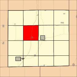 Location in Decatur County | |
| Coordinates: 40°45′59″N93°50′13″W / 40.76639°N 93.83694°W | |
| Country | |
| State | |
| County | Decatur |
| Area | |
• Total | 35.77 sq mi (92.65 km2) |
| • Land | 35.6 sq mi (92.3 km2) |
| • Water | 0.14 sq mi (0.35 km2) 0.38% |
| Elevation | 1,102 ft (336 m) |
| Population (2000) | |
• Total | 425 |
| • Density | 12/sq mi (4.6/km2) |
| GNIS feature ID | 0467689 |
Decatur Township is a township in Decatur County, Iowa, United States. As of the 2000 census, its population was 425.
