
Studland is a village and civil parish on the Isle of Purbeck in Dorset, England. The village is located about 2 miles (3.2 km) north of the town of Swanage, over a steep chalk ridge, and 3 miles (4.8 km) south of the South East Dorset conurbation at Sandbanks, from which it is separated by Poole Harbour. The parish includes Brownsea Island within the harbour. In the 2011 census the parish had 182 households and a population of 425, though many of the houses in the village are holiday homes, second homes, or guest houses, and the village's population varies depending upon the season.

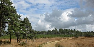
The Studland and Godlingston Heaths NNR is located on the Isle of Purbeck in the English county of Dorset. It borders Studland Bay on the south side of Poole Harbour, between the settlements of Swanage and Sandbanks. Extending to 631ha, it is owned and managed by the National Trust following the Bankes bequest of the Kingston Lacy estate. Studland & Godlingston Heath is designated as one of only 35 "spotlight reserves" in England by Natural England in the list of national nature reserves in England and is listed as a Site of Special Scientific Interest (SSSI).

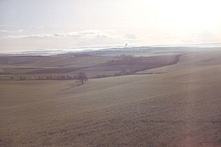
The Isle of Purbeck is a peninsula in Dorset, England. It is bordered by water on three sides: the English Channel to the south and east, where steep cliffs fall to the sea; and by the marshy lands of the River Frome and Poole Harbour to the north. Its western boundary is less well defined, with some medieval sources placing it at Flower's Barrow above Worbarrow Bay. According to writer and broadcaster Ralph Wightman, Purbeck "is only an island if you accept the barren heaths between Arish Mell and Wareham as cutting off this corner of Dorset as effectively as the sea." The most southerly point is St Alban's Head.

Purbeck was a local government district in Dorset, England. The district was named after the Isle of Purbeck, a peninsula that forms a large proportion of the district's area. However, it extended significantly further north and west than the traditional boundary of the Isle of Purbeck which is the River Frome. The district council was based in the town of Wareham, which is itself north of the Frome.
The Dorset Downs are an area of chalk downland in the centre of the county Dorset in south west England. The downs are the most western part of a larger chalk formation which also includes Cranborne Chase, Salisbury Plain, Hampshire Downs, Chiltern Hills, North Downs and South Downs.

Arne is a village and civil parish in Dorset, England, situated 4 miles (6.4 km) east of Wareham. The local travel links are located at Wareham railway station. Bournemouth International Airport is 11 miles (18 km) away. The main road through the village is Arne Road connecting Arne to Wareham. The village is situated on the Arne Peninsula, which protrudes into Poole Harbour opposite the town of Poole.
Wareham Forest is an area of countryside in Dorset, England, consisting of open heathland, including Decoy Heath and Gore Heath, and plantations of conifers such as Morden Heath and Bloxworth Heath. The site is managed by Forestry England for conservation and recreation. Situated next to the A35 road between Dorchester and Poole; the forest provides a home for sika deer, the Dartford warbler and a population of sand lizards.
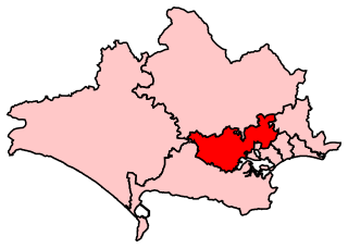
Mid Dorset and North Poole is a constituency represented in the House of Commons of the UK Parliament since 2015 by Michael Tomlinson, a Conservative.
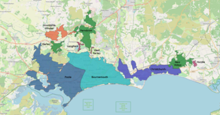
The South East Dorset conurbation is a multi-centred conurbation on the south coast of Dorset in England. The main population centres are Bournemouth, Christchurch and Poole, which together form the single unitary authority of Bournemouth, Christchurch and Poole; however, the urbanised area spreads into the Dorset unitary authority and into the New Forest District as far east as Barton on Sea. There are a number of satellite towns peripheral to these main urban centres. In clockwise rotation these include: Wareham, Verwood and Ringwood (Hampshire). The urban area is generally surrounded by a green belt.

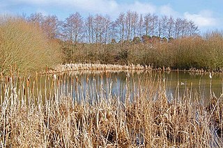
The Royal Naval Cordite Factory, Holton Heath (RNCF) was set up at Holton Heath, Dorset, England, in World War I to manufacture cordite for the Royal Navy. It was reactivated in World War II to manufacture gun propellants for the Admiralty and its output was supplemented by the Royal Navy Propellant Factory, Caerwent. After the end of World War II, the explosive manufacturing areas of the site were closed down and some areas of the site reopened as an Admiralty Research Establishment. A major part of the explosives site became a nature reserve in 1981. Other parts of the site were converted into an industrial estate; and some may be used for housing.
Ebblake Bog is a 11.3-hectare (28-acre) biological Site of Special Scientific Interest in Dorset and Hampshire, located west of Ringwood. It is part of Dorset Heathlands Ramsar site and Special Protection Area, and of Dorset Heaths Special Area of Conservation,

Wareham St Martin is a civil parish in the English county of Dorset. The parish spreads across a large, and mostly rural area to the north of the town of Wareham including much of Wareham Forest. However the town of Wareham lies within its own civil parish, and the only significant settlement within Wareham St. Martin parish is the village of Sandford on the A351 road between Wareham and Poole. The parish also includes the Holton Heath trading estate.
Holton Heath is an area of the parish of Wareham St. Martin, Dorset, England. The area includes a trading estate, on the site of the former Royal Navy Cordite Factory, Holton Heath, (RNCF). East of the trading estate is the Holton Heath National Nature Reserve, currently closed to the public.

Decoy Pit, Pools and Woods is a 17.7-hectare (44-acre) biological Site of Special Scientific Interest south of Aldermaston in Berkshire. An area of 8 hectares is a nature reserve called Decoy Heath, which is managed by the Berkshire, Buckinghamshire and Oxfordshire Wildlife Trust.

The Dorset Heaths form an important area of heathland within the Poole Basin in southern England. Much of the area is protected.

Gore Heath is an area of coniferous woodland and open heathland forming part of Wareham Forest west of the Poole-Bournemouth conurbation in south Dorset, England. It is part of the Dorset Heaths and an SSSI.
Bloxworth Heath is a four-square-mile area of heathland north of the town of Wareham in the county of Dorset, England. It is part of Wareham Forest.

