
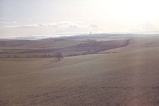
Studland is a village and civil parish on the Isle of Purbeck in Dorset, England. The village is located about 2 miles (3.2 km) north of the town of Swanage, over a steep chalk ridge, and 3 miles (4.8 km) south of the South East Dorset conurbation at Sandbanks, from which it is separated by Poole Harbour. The parish includes Brownsea Island within the harbour. In the 2011 census the parish had 182 households and a population of 425, though many of the houses in the village are holiday homes, second homes, or guest houses, and the village's population varies depending upon the season.

Lytchett Minster is a village in Dorset, England. It lies around 4 miles (6.4 km) north-west of Poole town centre. The village forms part of the civil parish of Lytchett Minster and Upton, Upton now being a suburb of Poole.

East Dorset was a local government district in Dorset, England. Its council met in Wimborne Minster between 2016 and 2019.
The Dorset Downs are an area of chalk downland in the centre of the county Dorset in south west England. The downs are the most western part of a larger chalk formation which also includes Cranborne Chase, Salisbury Plain, Hampshire Downs, Chiltern Hills, North Downs and South Downs.

Wootton Fitzpaine is a village and civil parish in the county of Dorset in South West England. It lies approximately 3 miles (4.8 km) north-east of Lyme Regis in a small side valley of the River Char, close to the Marshwood Vale. The civil parish covers an area of 3,307 acres (1,338 ha) and includes the ecclesiastical parish and small settlement of Monkton Wyld to the west. In the 2011 census the civil parish had 180 dwellings, 134 households and a population of 345.

Wytch Farm is an oil field and processing facility in the Purbeck district of Dorset, England. It is the largest onshore oil field in western Europe. The facility, taken over by Perenco in 2011, was previously operated by BP. It is located in a coniferous forest on Wytch Heath on the southern shore of Poole Harbour, two miles (3.2 km) north of Corfe Castle. Oil and natural gas (methane) are both exported by pipeline; liquefied petroleum gas is exported by road tanker.
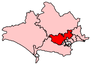
Mid Dorset and North Poole is a constituency represented in the House of Commons of the UK Parliament since 2015 by Michael Tomlinson, a Conservative.

Cambridge Heath is an urban area of Bethnal Green in the London Borough of Tower Hamlets, approximately 5.7 km (3.5 mi) north east of Charing Cross. It is named after a former heath in the East End of London. The northern boundary is formed by the Regent's Canal and the area includes Vyner Street, best known for its street art and galleries.

The South East Dorset conurbation is a multi-centred conurbation on the south coast of Dorset in England. The area is rapidly becoming an amalgamation with the area of South West Hampshire immediately on the fringe of the newly formed New Forest National Park. The main population centres are Bournemouth, Christchurch and Poole, which together form the single unitary authority of Bournemouth, Christchurch and Poole; however, the urbanised area spreads as far east as Barton on Sea in Hampshire. There are a number of satellite towns peripheral to these main urban centres. In clockwise rotation these include: Wareham, Upton, Wimborne, Ferndown, Verwood and Ringwood (Hampshire). The urban area is generally surrounded by a green belt.

Canford Heath is a suburb and area of heathland in Poole, Dorset, known for being the largest heathland in Dorset, and the largest lowland heath in the UK. It is also the name of the housing development built on the heathland in the 1960s, 1970s and 1980s. The area is split into 2 wards, and at the 2011 census, the combined population of the 2 wards was 14,079.

Newton's Cove is a small cove with sand, shingle and rock pools, 0.5 kilometres (0.3 mi) south of Weymouth, Dorset, England, overlooking Portland Harbour and next to the Nothe Fort. The beach is mainly used by locals and by tourists who visit the Nothe Gardens and the fort.

Bindon Hill is an extensive Iron Age earthwork enclosing a coastal hill area on the Jurassic Coast near Lulworth Cove in Dorset, England, about 19 kilometres (12 mi) west of Swanage, about 6 kilometres (3.7 mi) south west of Wareham, and about 17 kilometres (11 mi) south east of Dorchester. It is within an Area of Outstanding Natural Beauty.

Wareham St Martin is a civil parish in the English county of Dorset. The parish spreads across a large, and mostly rural area to the north of the town of Wareham including much of Wareham Forest. However the town of Wareham lies within its own civil parish, and the only significant settlement within Wareham St. Martin parish is the village of Sandford on the A351 road between Wareham and Poole. The parish also includes the Holton Heath trading estate.

Sandford is a village in the English county of Dorset, on the A351 road some two miles from Wareham and seven miles from Poole.

Upton Heath is one of the largest remaining fragments of a heath that once stretched across central southern England from Dorchester to Christchurch and beyond. Today it is confined to an area immediately west of Upton and Poole, much of which is protected. From the Heath there are views across Poole Harbour, Corfe Castle and the Isle of Purbeck.

Stoney Down or Stony Down is both a hill and an area of forested countryside in the county of Dorset, England, that has been designated an "Area of Great Landscape Value" (AGLV) in the East Dorset Local Plan. The forest is known as the Stoney Down Plantation or Stony Down Plantation. It covers an area of 51.13 hectares. The area is popular with riders and walkers.

Lytchett Heath is an area of woods and farmland on the Dorset Heaths between the villages of Lytchett Matravers, Lytchett Minster and the hamlet of Beacon Hill in the county of Dorset, England. Part of it is a reserve managed jointly by the Dorset Wildlife Trust and the Amphibian and Reptile Conservation Trust. St Aldhelm's was built in 1898 as a private church for Lord Eustace Cecil.
Bloxworth Heath is a four-square-mile area of heathland north of the town of Wareham in the county of Dorset, England. It is part of Wareham Forest.

Decoy Heath is an area of open heathland and bog forming part of Wareham Forest west of the Poole-Bournemouth conurbation in south Dorset, England. It is part of the Dorset Heaths.
Turbary Park is an area of West Howe, Bournemouth in Dorset. Turbary Park is south of Kinson and north of Wallisdown.
