Related Research Articles

Shaftesbury is a town and civil parish in Dorset, England. It is situated on the A30 road, 20 miles west of Salisbury, near the border with Wiltshire. It is the only significant hilltop settlement in Dorset, being built about 215 metres above sea level on a greensand hill on the edge of Cranborne Chase.

Kimmeridge is a small village and civil parish on the Isle of Purbeck, a peninsula on the English Channel coast in Dorset, England. It is situated about 4.5 miles (7.2 km) south of Wareham and 7 miles (11 km) west of Swanage. In 2013 the estimated population of the civil parish was 90.

Abbotsbury is a village and civil parish in the English county of Dorset. The settlement is in the unitary authority of Dorset about 1 mile (1.6 km) inland from the English Channel coast. The village, including Chesil Beach, the swannery and subtropical gardens, is owned by the Ilchester Estate, which owns 61 square kilometres of land in Dorset. In the 2011 census the civil parish had a population of 481.
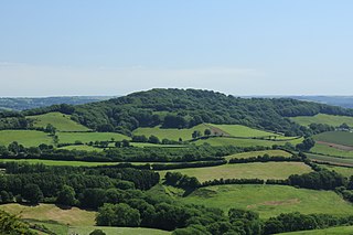
Hambledon Hill is a prehistoric hill fort in Dorset, England, situated in the Blackmore Vale five miles northwest of Blandford Forum. The hill itself is a chalk outcrop, on the southwestern corner of Cranborne Chase, separated from the Dorset Downs by the River Stour. It is owned by the National Trust.

Buckland Newton is a village and civil parish in Dorset, England. It is situated beneath the scarp slope of the Dorset Downs, 7+1⁄2 miles (12.1 km) south of Sherborne. In the 2011 census the civil parish had a population of 622. The village covers around 6000 acres.

Melcombe Horsey is a civil parish in the county of Dorset in South West England. It contains the small settlements of Melcombe Bingham, Bingham's Melcombe and Higher Melcombe, the last being the site of the deserted village of Melcombe Horsey. In the 2011 census the parish had a population of 141.

Rampisham is a village and civil parish in the county of Dorset in southern England, situated approximately 11 miles (18 km) northwest of the county town Dorchester. The village is sited on greensand in a valley surrounded by the chalk hills of the Dorset Downs. The parish includes the hamlet of Uphall northwest of the main village.

Tarrant Monkton is a village and civil parish in north Dorset, England, situated in the Tarrant Valley about four miles east-northeast of Blandford Forum. Within the parish boundary, 1+1⁄2 miles over hills to the west, lies the major part of Blandford Camp army base. In the 2011 census the parish—including the army base—had a population of 1,986. The village is centred on the All Saints Parish Church, opposite which is the Langton Arms, a public house and restaurant.

Farnham is a village and civil parish in North Dorset, in the south of England, on Cranborne Chase, seven miles northeast of Blandford Forum. In the 2011 census the parish had a population of 183.
Lewesdon Hill is a hill in west Dorset, England. With a maximum elevation of 279 m (915 ft), it is the highest point in Dorset.
Beacon Hill is one of the highest viewpoints in the hinterland of Poole Harbour, Dorset. Its tree-covered summit reaches 84 metres (276 ft) above sea level and there is a public footpath running roughly north to south over the top. Historically it was one of a series of beacons used to warn of the advancing Spanish Armada. The earlier name for the hill was Lytchett Beacon.

The Hampshire Basin is a geological basin of Palaeogene age in southern England, underlying parts of Hampshire, the Isle of Wight, Dorset, and Sussex. Like the London Basin to the northeast, it is filled with sands and clays of Paleocene and younger ages and it is surrounded by a broken rim of chalk hills of Cretaceous age.

Ordnance Survey (OS) is the national mapping agency for Great Britain. The agency's name indicates its original military purpose, which was to map Scotland in the wake of the Jacobite rising of 1745. There was also a more general and nationwide need in light of the potential threat of invasion during the Napoleonic Wars. Since 1 April 2015 Ordnance Survey has operated as Ordnance Survey Ltd, a government-owned company, 100% in public ownership. The Ordnance Survey Board remains accountable to the Secretary of State for Business, Energy and Industrial Strategy. It was also a member of the Public Data Group.

The Dorset Heaths form an important area of heathland within the Poole Basin in southern England. Much of the area is protected.
Langton Long Blandford is a small village and civil parish in the county of Dorset in southern England. It is sited by the River Stour, approximately 3⁄4 mile southeast of Blandford Forum. In 2013 the estimated population of the parish was 120.
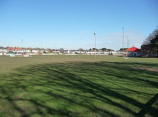
Victoria Park, Bournemouth is a football ground in Victoria Park in Bournemouth and has been the home of Bournemouth F.C. since 1890. It was also a short lived greyhound racing track from 1928 to 1934.
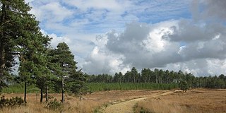
Bloxworth Heath is a four-square-mile area of heathland north of the town of Wareham in the county of Dorset, England. It is part of Wareham Forest.

The River Sherford, also frequently called the Sherford River, is one of the four main rivers flowing into Poole Harbour in the county of Dorset, England. It is about 12 kilometres long and drains over the tertiary beds near the harbour.

The Corfe River is one of the four main rivers flowing into Poole Harbour in the county of Dorset, England. It is just under 9 kilometres long.
References
| | This Dorset location article is a stub. You can help Wikipedia by expanding it. |