A municipality is usually a single administrative division having corporate status and powers of self-government or jurisdiction as granted by national and regional laws to which it is subordinate.

A metropolitan area or metro is a region consisting of a densely populated urban agglomeration and its surrounding territories which are sharing industries, commercial areas, transport network, infrastructures and housing. A metropolitan area usually comprises multiple principal cities, jurisdictions and municipalities: neighborhoods, townships, boroughs, cities, towns, exurbs, suburbs, counties, districts and even states and nations in areas like the eurodistricts. As social, economic and political institutions have changed, metropolitan areas have become key economic and political regions.
Gifhorn is a district in Lower Saxony, Germany.

Belgium is a federal state comprising three communities and three regions that are based on four language areas. For each of these subdivision types, the subdivisions together make up the entire country; in other words, the types overlap.

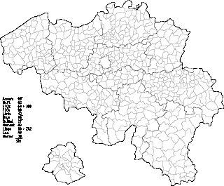
Belgium comprises 581 municipalities, 300 of them grouped into five provinces in Flanders and 262 others in five provinces in Wallonia, while the remaining 19 are in the Brussels Capital Region, which is not divided in provinces. In most cases, the municipalities are the smallest administrative subdivisions of Belgium, but in municipalities with more than 100,000 inhabitants, on the initiative of the local council, sub-municipal administrative entities with elected councils may be created. As such, only Antwerp, having over 500,000 inhabitants, became subdivided into nine districts. The Belgian arrondissements, an administrative level between province and municipality, or the lowest judicial level, are in English sometimes called districts as well.
Amt is a type of administrative division governing a group of municipalities, today only in Germany, but formerly also common in other countries of Northern Europe. Its size and functions differ by country and the term is roughly equivalent to a British or U.S. county.
A Verbandsgemeinde is a low-level administrative unit in the German federal states of Rhineland-Palatinate and Saxony-Anhalt. A Verbandsgemeinde is typically composed of a small group of villages or towns.

An unincorporated area is a region that is not governed by a local municipal corporation. There are many unincorporated communities and areas in the United States and Canada.

The German-speaking Community, also known as East Belgium, is one of the three federal communities of Belgium, with an area of 854 km2 (330 sq mi) in the Liège Province of Wallonia, including nine of the eleven municipalities of Eupen-Malmedy. The primary language of the community is German, making this one of the three official languages in Belgium. Traditionally the community and the wider area around it forms an intersection of various local languages and/or dialects, namely Limburgish, Ripuarian and Moselle Franconian varieties. The community population numbers around 79,000 – about 7.0% of Liège Province and about 0.7% of the national total.

Municipalities are the lowest level of administrative division in Switzerland. Each municipality is part of one of the Swiss cantons, which form the Swiss Confederation. In most cantons, municipalities are also part of districts or other sub-cantonal administrative divisions.

In 13 German states, the primary administrative subdivision higher than a Gemeinde (municipality) is the Landkreis or Kreis. Most major cities in Germany are not part of any Kreis, but instead combine the functions of a municipality and a Kreis; such a city is referred to as a kreisfreie Stadt or Stadtkreis.
The Official Municipality Key, formerly also known as the Official Municipality Characteristic Number or Municipality Code Number, is a number sequence for the identification of politically independent municipalities or unincorporated areas. Other classifications for the identification of areas include postal codes, NUTS codes or FIPS codes.

Municipalities are the lowest level of official territorial division in Germany. This can be the second, third, fourth or fifth level of territorial division, depending on the status of the municipality and the Land it is part of. The city-states Berlin, Bremen and Hamburg are second-level divisions. A Gemeinde is one level lower in those states which also include Regierungsbezirke as an intermediate territorial division. The Gemeinde is one level higher if it is not part of a Gemeindeverband.

Hankensbüttel is a municipality in the Samtgemeinde Hankensbüttel in the district of Gifhorn, Lower Saxony, Germany. It is situated approximately 25 km south of Uelzen, and 30 km north of Gifhorn. The Municipality Hankensbüttel includes the villages of Alt Isenhagen, Emmen and Hankensbüttel.
A Samtgemeinde is a type of administrative division in Lower Saxony, Germany. Samtgemeinden are local government associations of municipalities, equivalent to the Ämter in Schleswig-Holstein, Mecklenburg-Vorpommern, and Brandenburg, and the Verbandsgemeinden in Rhineland-Palatinate.

Bundesstraße 84 or B84 is a federal road in Lower Saxony, Germany. It connects Hünfeld in Hesse via Eisenach with Ebeleben in Thuringia. It comes off of the B4, which is located west of Dedelstorf towards the east. It then goes through: Wittingen, Brome, Rühen, Velpke, Helmstedt, Schöningen, Dardesheim and Wernigerode, finishing at Elbingerode, culminating at the B 27.
Municipal associations are statutory corporations or public bodies created by statute in the German federal states of Bavaria, Saxony, Thuringia, and Schleswig-Holstein. In Baden-Württemberg the term stipulated municipal association is used.


