
A municipality is usually a single administrative division having corporate status and powers of self-government or jurisdiction as granted by national and regional laws to which it is subordinate.

A metropolitan area or metro is a region of a densely populated urban agglomeration and its surrounding territories sharing industries, commercial areas, transport network, infrastructures and housing. A metro area usually comprises multiple principal cities, jurisdictions and municipalities: neighborhoods, townships, boroughs, cities, towns, exurbs, suburbs, counties, districts, as well as even states and nations like the euro districts. As social, economic and political institutions have changed, metropolitan areas have become key economic and political regions.
Gifhorn is a district in Lower Saxony, Germany.

Belgium is a federal state comprising three communities and three regions that are based on four language areas. For each of these subdivision types, the subdivisions together make up the entire country; in other words, the types overlap.
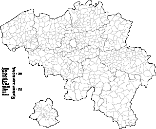
Belgium comprises 581 municipalities, 300 of them grouped into five provinces in Flanders and 262 others in five provinces in Wallonia, while the remaining 19 are in the Brussels Capital Region, which is not divided in provinces. In most cases, the municipalities are the smallest administrative subdivisions of Belgium, but in municipalities with more than 100,000 inhabitants, on the initiative of the local council, sub-municipal administrative entities with elected councils may be created. As such, only Antwerp, having over 500,000 inhabitants, became subdivided into nine districts. The Belgian arrondissements, an administrative level between province and municipality, or the lowest judicial level, are in English sometimes called districts as well.
Amt is a type of administrative division governing a group of municipalities, today only in Germany, but formerly also common in other countries of Northern Europe. Its size and functions differ by country and the term is roughly equivalent to a US township or county or English shire district.
A Verbandsgemeinde is a low-level administrative unit in the German federal states of Rhineland-Palatinate and Saxony-Anhalt. A Verbandsgemeinde is typically composed of a small group of villages or towns.

The Federal Republic of Germany, as a federal state, consists of sixteen states. Berlin, Hamburg and Bremen are called Stadtstaaten ("city-states"), while the other thirteen states are called Flächenländer and include Bavaria, Saxony, and Thuringia which describe themselves as Freistaaten.

An unincorporated area is a region that is not governed by a local municipal corporation. Widespread unincorporated communities and areas are a distinguishing feature of the United States and Canada. Most other countries of the world either have no unincorporated areas at all or these are very rare. They are typically remote, outlying, sparsely populated or uninhabited areas.

Amfreville is a commune in the Calvados department in the Normandy region of north-western France.

Municipalities are the lowest level of administrative division in Switzerland. Each municipality is part of one of the Swiss cantons, which form the Swiss Confederation. In most cantons, municipalities are also part of districts or other sub-cantonal administrative divisions.
The Official Municipality Key, formerly also known as the Official Municipality Characteristic Number or Municipality Code Number, is a number sequence for the identification of politically independent municipalities or unincorporated areas. Other classifications for the identification of areas include postal codes, NUTS codes or FIPS codes.
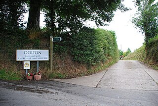
Dolton is a small village and civil parish in the Torridge district of Devon, south-west England, surrounded, clockwise from the north, by Beaford, Ashreigney, Winkleigh, Dowland, Meeth, Huish and Merton. It has a population of around 900.

Municipalities are the lowest level of official territorial division in Germany. This can be the second, third, fourth or fifth level of territorial division, depending on the status of the municipality and the Land it is part of. The city-states Berlin and Hamburg are second-level divisions. A Gemeinde is one level lower in those states which also include Regierungsbezirke as an intermediate territorial division. The Gemeinde is one level higher if it is not part of a Gemeindeverband.
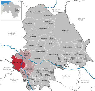
Meinersen is a municipality in the district of Gifhorn, in Lower Saxony, Germany. It is situated between the rivers Oker and Aller, approx. 12 km west of Gifhorn, and 25 km southeast of Celle. The Municipality Meinersen includes the villages of Ahnsen, Böckelse, Hardesse, Höfen, Hünenberg, Meinersen, Ohof, Päse, Seershausen, Siedersdamm and Warmse.
Municipal associations are statutory corporations or public bodies created by statute in the German federal states of Bavaria, Saxony, Thuringia, and Schleswig-Holstein. In Baden-Württemberg the term stipulated municipal association is used.
The 2011–12 season of Eintracht Braunschweig began on 5 June with a first training session. It is the club's first season in the 2. Bundesliga after being promoted from the 3. Liga. Eintracht started the season successfully with wins over 1860 Munich and Alemannia Aachen, leading the league on the first and second matchday. In the end the club finished the season as 8th, never being in serious danger of relegation.

Grossenrode is a district of the town of Moringen in Northeim, Lower Saxony, Germany. It has about 330 inhabitants. Nearby places include Behrensen, Elvese, Hillerse, Schnedinghausen, Thüdinghausen, and Wolbrechtshausen.


