
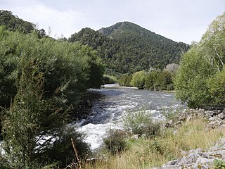
The Alfred River is a river in New Zealand's Tasman region. It runs west-southwest from its source in the Spenser Mountains to its junction with the Maruia River. The schist in the river contains hornblende. The area has a temperate oceanic climate. Gold is said to have been found in the area.
Te Kauparenui / Gowan River is in the South Island of New Zealand. Its source is at Lake Rotoroa and travels 11 kilometres before feeding into the Buller River. Mixed farming and forestry occurs on both banks of the river. The river has introduced trout which attracts recreational fishing.

The Waimakariri River is one of the largest rivers in Canterbury, on the eastern coast of New Zealand's South Island. It flows for 151 kilometres (94 mi) in a generally southeastward direction from the Southern Alps across the Canterbury Plains to the Pacific Ocean.
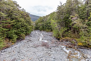
The Maruia River is located in the northwestern South Island of New Zealand. It is a major tributary of the Buller River, flowing for 80 km before joining the larger river eight kilometres to the west of Murchison.
The Inangahua River is located in the north-west of New Zealand’s South Island. It is a major tributary of the Buller River, where it joins at the town of Inangahua Junction.
The Mātakitaki River is located in the north of New Zealand's South Island. An upper tributary of the Buller River, it flows north and west for 65 kilometres from its source north of the Lewis Pass, joining the Buller at Murchison. It has one major tributary, the Glenroy River.

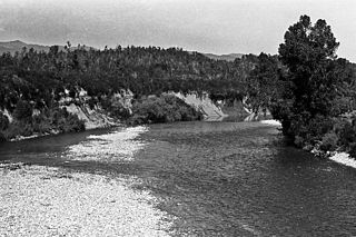
The Buller Gorge is a gorge located in the northwest of the South Island of New Zealand. The Buller River flows through the deep canyon between Murchison and Westport. Land Information New Zealand lists two sections for the gorge, Upper Buller Gorge and Lower Buller Gorge. State Highway 6 runs alongside, but considerably above, the river through the gorge. The Stillwater - Westport Line railway also runs through the gorge.

Arapito is a town in the Karamea area of New Zealand. Arapito is a farming community on the south side of the Karamea River, upriver from the main Karamea township.
The Glasgow Range is a mountain range on the northern West Coast of New Zealand's South Island. It is north of the Papahaua Range and its most significant river is the Mōkihinui River.

Honeycomb Hill Cave is located in the Oparara Basin, on the northwestern edge of the South Island of New Zealand. The Oparara River flows through a section of the cave.

The Doubtful River is a river in the Canterbury region of New Zealand. It rises near Mount Barron and flows south then south-east through Lake Sumner Forest Park, reaching the Boyle River 40 kilometres (25 mi) west of Hanmer Springs. The Doubtful Range lies to the south. The Doubtless River and Devilskin Stream are tributaries entering from the north.
The Glencoe River is a river in the Canterbury region of New Zealand. It arises in the Organ Range near Shale Peak and flows south into the Mandamus River.
The Glenrae River is a river in the Canterbury region of New Zealand. It arises in the Glynn Wye Range near Mount Skiddaw and flows through the Lake Sumner Forest Park south and then south-east into the Hurunui River, which exits in the Pacific Ocean. Its tributaries include Devils Creek and Robyne Creek.

The Glentui River is a river in the Canterbury region of New Zealand. It arises on the slopes of Mount Richardson and flows south-east through the locality of Glentui and into Ashley River / Rakahuri, which exits in the Pacific Ocean. The river was earlier called Tui Creek, and the locality named from the station Glentui established by H.C.H. Knowles in 1854.

The Hanmer River is a river in the Hurunui District of New Zealand. It originates in the Hossack Saddle between the Hanmer Range and the Amuri Range, and flows south-west into the Waiau Uwha River about 8 kilometres (5.0 mi) south-west of Hanmer Springs.
The Hinemoatū / Howard River is a river of the northern South Island of New Zealand. A tributary of the Buller River, the Hinemoatū/Howard starts at the confluence of the Hodgson and Tier Streams in the Travers Range of Nelson Lakes National Park, flowing north between Lakes Rotoroa and Rotoiti, before reaching the Buller between Kawatiri and Saint Arnaud. Close to its confluence with the Buller, the river is bridged by State Highway 63 and further up by Howard Valley Road.
The Dove River is a river in the Tasman Region of New Zealand. It arises in hills between the Wai-iti River and Motueka River and flows north-west into the Motueka near the locality of Woodstock. The river is named for the native New Zealand pigeons once found in the forests around the river.
Woodstock is a small settlement in the Tasman District of the northern South Island of New Zealand. It is located on the Motueka Valley Highway, close to the eastern bank of the Motueka River, some 20 kilometres southwest of Motueka, at the junction of the Motueka River and its small tributary, the Dove River.

The Blackwater River is located in the Buller District of New Zealand. It flows north-northwest for 19 kilometres (12 mi) from the northern slopes of Mount Copernicus in the Paparoa Range, reaching the Buller River 16 kilometres (9.9 mi) west of Inangahua in the lower Buller Gorge.

Umere is a town in the Karamea area of New Zealand. Umere is a farming community on the north side of the Karamea River, upriver from the main Karamea township.
