
The Vestingwet [3] (eng: Fortification Law) or Wet tot regeling en voltooiing van het vestingstelsel (eng: Law to regulate and complete the fortification) was signed on 18 April 1874. The law dealt with the defense of the Netherlands against enemy attacks.
The main principle was defense by flooding where as the army of the Netherlands would withdraw to the area around Amsterdam. After the Franco-Prussian War (1870–1871) it became clear that a new defense plan was needed. The law was made by the Minister of War August Weitzel under King Willem III. The Law became dysfunctional at 28 March 1938.
During the occupation of the Netherlands, the Germans made fortifications to stop the Allies from liberating the Netherlands and to protect their V2 rocket platforms in the Netherlands. The Germans built new defense lines like the Atlantic Wall but also reused the Dutch defense line like the Grebbe line.
During the Cold War a defence line was created to slow down a potential Soviet attack on the Netherlands. [7]


North Brabant, also unofficially called Brabant, is a province in the south of the Netherlands. It borders the provinces of South Holland and Gelderland to the north, Limburg to the east, Zeeland to the west, and the Flemish provinces of Antwerp and Limburg to the south. The northern border follows the Meuse westward to its mouth in the Hollands Diep strait, part of the Rhine–Meuse–Scheldt delta. North Brabant had a population of about 2,626,000 as of January 2023. Major cities in North Brabant are Eindhoven, Tilburg, Breda, its provincial capital 's-Hertogenbosch, and Helmond
Muiden is a city and former municipality in the Netherlands, in the province of North Holland. It lies at the mouth of the Vecht and is in an area called the Vechtstreek. Since 2016, Muiden has been part of the new municipality of Gooise Meren.

Henri Gerard Winkelman was a Dutch military officer who served as Commander-in-chief of the Armed forces of the Netherlands during the German invasion of the Netherlands.

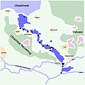
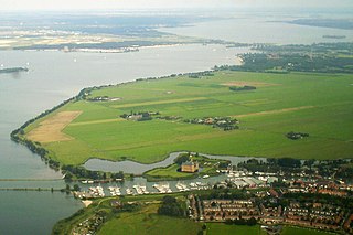
The Stelling van Amsterdam is a 135-kilometre (84 mi) fortification line around Amsterdam, which would function as a national redoubt. It comprises 45 forts, as well as dams, dikes, locks, pumping stations, batteries and casemates. The forts are 10–15 kilometres (6.2–9.3 mi) from the centre and lowlands, which can easily be inundated in time of war. The inundation was designed to give a depth of about 30 centimetres (12 in), too little for boats to cross. Any buildings within 1 kilometre (0.62 mi) of the line had to be made of wood so that they could be burnt and the obstruction removed.
The Netherlands entered World War II on May 10, 1940, when invading German forces quickly overran the country. On December 7, 1941, after the attack on Pearl Harbor, the Netherlands government in exile also declared war on Japan. Operation Market Garden, which started in 1944, liberated the southern and eastern parts of the country, but full liberation did not come until the surrender of Germany on May 5, 1945.

Numansdorp is a town and former municipality in the province South Holland in the Netherlands and is located on the island Hoeksche Waard near the Hollands Diep. On 1 January 1984, the municipalities Numansdorp and Klaaswaal were merged into one municipality called Cromstrijen. Cromstrijen was merged into the new municipality Hoeksche Waard in January 2019.

The Dutch Waterline was a series of water-based defences conceived by Maurice of Nassau in the early 17th century, and realised by his half brother Frederick Henry. Combined with natural bodies of water, the Waterline could be used to transform Holland, the westernmost region of the Netherlands and adjacent to the North Sea, almost into an island. In the 19th century, the Line was extended to include Utrecht.

The German invasion of the Netherlands, otherwise known as the Battle of the Netherlands, was a military campaign, part of Case Yellow, the Nazi German invasion of the Low Countries and France during World War II. The battle lasted from 10 May 1940 until the surrender of the main Dutch forces on 14 May. Dutch troops in the province of Zealand continued to resist the Wehrmacht until 17 May, when Germany completed its occupation of the whole country.

The Koningshooikt–Wavre Line, abbreviated to KW Line and often known as the Dyle Line after the Dijle (Dyle) river, was a 60 kilometres (37 mi)-long fortified line of defence prepared by the Belgian Army between Koningshooikt and Wavre which was intended to protect Brussels from a possible German invasion. Construction on the KW Line began in September 1939 after World War II had begun but while Belgium itself remained a neutral state. It was subsequently extended southwards from Wavre towards Namur. The line itself consisted of bunkers, anti-tank ditches, and barricades including so-called Cointet-elements and played a key role in Allied strategy during the German invasion of Belgium in May 1940. However, its role in the actual fighting was ultimately minimal. In 2009 an inventory of surviving emplacements was begun.

The Grebbe Line was a forward defence line of the Dutch Water Line, based on inundation. The Grebbe Line ran from the Grebbeberg in Rhenen northwards until the IJsselmeer.

Willemstad is a city in the Dutch province of North Brabant. It is located in the municipality of Moerdijk. Its population as of 2021 was 2,490.

The Rhine–Meuse–Scheldt delta is a river delta in the Netherlands formed by the confluence of the Rhine, the Meuse and the Scheldt rivers. In some cases, the Scheldt delta is considered a separate delta to the Rhine–Meuse delta. The result is a multitude of islands, branches and branch names, in which a waterway that appears to be one continuous stream may have numerous separate names for different sections, e.g. Rhine → Bijlands Kanaal → Pannerdens Kanaal → Nederrijn → Lek → Nieuwe Maas → Het Scheur → Nieuwe Waterweg. Since the Rhine contributes most of the water, the term "Rhine Delta" is commonly used, although this name is also used for the delta where the Alpine Rhine flows into Lake Constance. By some calculations, the Rhine–Meuse–Scheldt delta covers 25,347 km2 (9,787 sq mi), making it the largest in Europe.
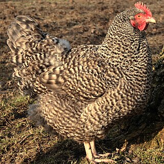
The North Holland Blue, Dutch: Noord-Hollandse Blauwe or Noord-Hollandse Hoen, is a Dutch breed of domestic chicken originating in the province of North Holland. It is a heavy meat breed, and was created to supply the high demand for white chicken meat from the city of Amsterdam, particularly from the Jewish community in that city.

The Peel-Raam Line was a Dutch defence line built in 1939 and attacked and conquered on 10 May 1940 by the German forces.

The walls of Amsterdam were built in the Middle Ages to protect the city against attack. The Medieval walls were replaced with a series of bastions in the 17th century. In the 19th century, the walls were torn down and replaced with the Defence Line of Amsterdam, a fortification line which encircled Amsterdam at a distance from the city.

HNLMS Noord-Brabant (D810) was a Holland-class anti-submarine destroyer of the Royal Netherlands Navy. The ship was from 1955 to 1974 in Dutch service. On 9 January 1974, HNLMS Noord-Brabant was rammed amidships by an English merchant ship. The damage was estimated to be expensive so the Royal Netherlands Navy decided to not repair the damage but instead decommission the ship earlier than planned. The ship's radio call sign was "PAIP".

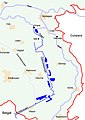
The West Brabant waterline is a Dutch military defense line based on inundation.