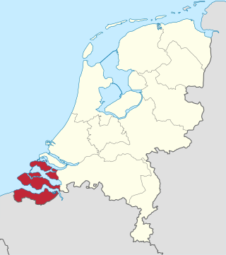
Zeeland is the westernmost and least populous province of the Netherlands. The province, located in the southwest of the country, borders North Brabant to the east, South Holland to the north, as well as the country of Belgium to the south and west. It consists of a number of islands and peninsulas and a strip bordering the Flemish provinces of East and West Flanders. Its capital is Middelburg with a population of 48,544 as of November 2019, although the largest municipality in Zeeland is Terneuzen. Zeeland has two seaports: Vlissingen and Terneuzen. Its area is 2,933 square kilometres (1,132 sq mi), of which 1,154 square kilometres (446 sq mi) is water; it had a population of about 391,000 as of January 2023.

North Brabant, also unofficially called Brabant, is a province in the south of the Netherlands. It borders the provinces of South Holland and Gelderland to the north, Limburg to the east, Zeeland to the west, and the Flemish provinces of Antwerp and Limburg to the south. The northern border follows the Meuse westward to its mouth in the Hollands Diep strait, part of the Rhine–Meuse–Scheldt delta. North Brabant had a population of about 2,626,000 as of January 2023. Major cities in North Brabant are Eindhoven, Tilburg, Breda, its provincial capital 's-Hertogenbosch, and Helmond

The Eastern Scheldt is a former estuary in the province of Zeeland, Netherlands, between Schouwen-Duiveland and Tholen on the north and Noord-Beveland and Zuid-Beveland on the south. It also features the largest national park in the Netherlands, founded in 2002.

Bergen op Zoom is a city and municipality in southwestern Netherlands. It is located in the province of North Brabant, at the provincial border with Zeeland. In January 2021, the municipality had a population of 67,514.

The Stelling van Amsterdam is a 135-kilometre (84 mi) fortification line around Amsterdam, which would function as a national redoubt. It comprises 45 forts, as well as dams, dikes, locks, pumping stations, batteries and casemates. The forts are 10–15 kilometres (6.2–9.3 mi) from the centre and lowlands, which can easily be inundated in time of war. The inundation was designed to give a depth of about 30 centimetres (12 in), too little for boats to cross. Any buildings within 1 kilometre (0.62 mi) of the line had to be made of wood so that they could be burnt and the obstruction removed.

The Dutch Waterline was a series of water-based defences conceived by Maurice of Nassau in the early 17th century, and realised by his half brother Frederick Henry. Combined with natural bodies of water, the Waterline could be used to transform Holland, the westernmost region of the Netherlands and adjacent to the North Sea, almost into an island. In the 19th century, the Line was extended to include Utrecht.
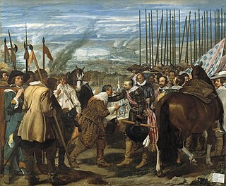
The Siege of Breda of 1624–1625 occurred during the Eighty Years' War. The siege resulted in Breda, a Dutch fortified city, falling into the control of the Army of Flanders.

The Duchy of Brabant, a state of the Holy Roman Empire, was established in 1183. It developed from the Landgraviate of Brabant of 1085–1183, and formed the heart of the historic Low Countries. The Duchy comprised part of the Burgundian Netherlands from 1430 and of the Habsburg Netherlands from 1482, until it was partitioned after the Dutch revolt of 1566–1648.

The Koningshooikt–Wavre Line, abbreviated to KW Line and often known as the Dyle Line after the Dijle (Dyle) river, was a 60 kilometres (37 mi)-long fortified line of defence prepared by the Belgian Army between Koningshooikt and Wavre which was intended to protect Brussels from a possible German invasion. Construction on the KW Line began in September 1939 after World War II had begun but while Belgium itself remained a neutral state. It was subsequently extended southwards from Wavre towards Namur. The line itself consisted of bunkers, anti-tank ditches, and barricades including so-called Cointet-elements and played a key role in Allied strategy during the German invasion of Belgium in May 1940. However, its role in the actual fighting was ultimately minimal. In 2009 an inventory of surviving emplacements was begun.

The Siege of Bergen op Zoom was a siege that took place between September 23 - November 13, 1588, during the Eighty Years' War and the Anglo–Spanish War. The siege took place in the aftermath of the Spanish Armada when famed commander Alexander Farnese, the Duke of Parma attempted to use his forces to besiege Bergen op Zoom, which was held by an Anglo-Dutch force under Thomas Morgan and Peregrine Bertie. An English officer named Grimstone, claiming to be a disaffected Catholic, had set up a trap during which a large Spanish assault was bloodily repulsed. An Anglo-Dutch relief column under the command Maurice of Orange arrived soon after and forced the Duke of Parma to retreat, thus ending the siege.

The A4 motorway, also called Rijksweg 4, is a motorway in the Netherlands running southwards from Amsterdam to the Belgian border near Zandvliet, north of the city of Antwerp. The 119-kilometre-long (74 mi) A4 is divided into two sections; the first and longer section runs from Amsterdam to the A15 near the city of Rotterdam, while the second section starts near Heijningen, where the A29 and the A4 meet, going to the Belgian border.
The Battle of Zeeland occurred on the Western Front during the early stages of the German assault on France and the Low Countries during World War II. Several Dutch and French units attempted to hold off the German onslaught by making a determined defense of the Dutch province of Zeeland. The battle lasted eight days and was a defeat for the French and Dutch forces defending the province.

The Siege of Bergen op Zoom took place during the Austrian War of Succession, when a French army, under the command of Count Löwendal and the overall direction of Marshal Maurice de Saxe, laid siege and captured the strategic Dutch border fortress of Bergen op Zoom on the border of Brabant and Zeeland in 1747. The fortress was defended by Dutch, Austrians, British, Hanoverians and Hessians that supported the Pragmatic Sanction.
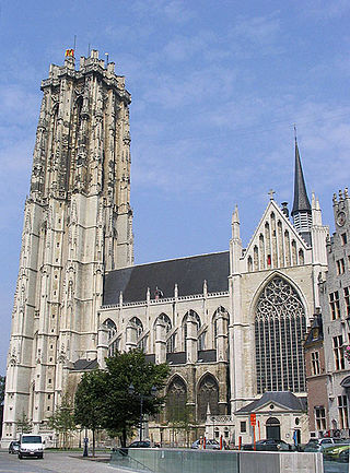
Brabantine Gothic, occasionally called Brabantian Gothic, is a significant variant of Gothic architecture that is typical for the Low Countries. It surfaced in the first half of the 14th century at St. Rumbold's Cathedral in the city of Mechelen.

Fort De Roovere is an earthen fort, constructed as part of the Dutch Water Line,, a series of water-based defences conceived by Maurice of Nassau in 1628 during the Eighty Years War where it defended against Spanish attackers. It is located near Halsteren.

The Battle of Steenbergen, also known as the Capture of Steenbergen of 1583, took place on 17 June 1583 at Steenbergen, Duchy of Brabant, Spanish Netherlands. This was an important victory for the Spanish Army of Flanders led by Don Alexander Farnese, Prince of Parma, Governor-General of the Spanish Netherlands, over the French, English, and Dutch forces led by the French Marshal Armand de Gontaut, Baron de Biron, and the English commander Sir John Norreys, during the Eighty Years' War, the Anglo-Spanish War (1585–1604), and in the context of the French Wars of Religion. The victory of the Spaniards ended the Treaty of Plessis-les-Tours, and Francis, Duke of Anjou (French: François de France), left the Netherlands in late June.

Operation Pheasant, also known as the Liberation of North Brabant, was a major operation to clear German troops from the province of North Brabant in the Netherlands during the fighting on the Western Front in the Second World War. This offensive was conceived as a result of the failure of Operation Market Garden and the allied effort to capture the important port of Antwerp. It was conducted by the allied 21st Army Group between 20 October to 4 November 1944.

Fort Crèvecoeur was a Dutch fortress near 's-Hertogenbosch. It is now used as a military exercise terrain.

Sugar Factory Zeeland was a beet sugar factory in Bergen op Zoom, a city and municipality in the North Brabant province in the Southwestern Netherlands. It got its peculiar name when it was sold to the Coöperatieve Beetwortelsuikerfabriek Zeeland, a cooperative of sugar beet farmers from neighboring Zeeland province. The factory was in operation from 1863 to 1929. Some of the imposing factory buildings remain and are protected as industrial heritage. In 2012 a reconstruction started to change the old buildings to a large shopping mall called De Zeeland.


