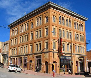
The City of Victor is a Statutory City in Teller County, Colorado, United States. Gold was discovered in Victor in the late 19th century, an omen of the future of the town. With Cripple Creek, the mining district became the second largest gold mining district in the country and realized approximately $10 billion of mined gold in 2010 dollars. It reached its peak around the turn of the century when there were about 18,000 residents in the town. Depleted ore in mines, labor strife and the exodus of miners during World War I caused a steep decline in the city's economy, from which it has never recovered. The population was 397 at the 2010 census. There is a resumed mining effort on Battle Mountain.

The Stickeen Territories, also colloquially rendered as Stickeen Territory,Stikine Territory, and Stikeen Territory, was a territory of British North America whose brief existence began July 19, 1862, and concluded July of the following year. The region was split from the North-Western Territory in the wake of the Stikine Gold Rush. The initial strike attracted large numbers of miners — mostly American — to the region; by detaching the region from the exclusive trade zone of the Hudson's Bay Company, British authorities were able to impose tariffs and licences on the speculators. The new territory, named after the Stikine River, was under the responsibility of the Governor of the Colony of British Columbia, James Douglas, who was appointed "Administrator of the Stickeen Territories" and under British law, within the jurisdiction of the Supreme Court of British Columbia.
The Tahltan First Nation, also known as the Tahltan Indian Band, is a band government of the Tahltan people. Their main community and reserves are located at Telegraph Creek, British Columbia. Their language is the Tahltan language, which is an Athabaskan language also known as Nahanni, is closely related to Kaska and Dunneza. Their Indian and Northern Affairs Canada band number is 682. The Tahltan First Nation is joined with the Iskut First Nation in a combined tribal council-type organization known as the Tahltan Nation.

Kowee Creek is a river on Douglas Island in the City and Borough of Juneau, Alaska, United States. Its origin is southeast of Mount Troy and it flows north-northeast to Gastineau Channel near West Juneau; it is 0.5 miles (0.80 km) southwest of the city of Juneau. Kowee Creek is nearly 10 miles (16 km) long. It has a drainage basin of about 50 square miles (130 km2) and two transverse tributaries.

Defot is a locality and former mining boomtown in the Cassiar Country of the Northern Interior of British Columbia, Canada, located west of Mount Defot.

Gold Rush is a reality television series that airs on Discovery and its affiliates worldwide. The series follows the placer gold mining efforts of various family-run mining companies, mostly in the Klondike region of Dawson City, Yukon, Canada. In its 11th season as of early 2020, prior seasons also included mining efforts in South America and western North America.
Granite Creek is a creek and townsite in British Columbia located in the Similkameen region. Granite Creek flows north into the Tulameen River and joins that river approximately one and a half miles to the east of Coalmont, British Columbia. It is assumed Granite Creek yielded more than $500,000 in placer gold since its discovery. Gold nuggets worth $50 in value were not unusual in the early years. The creek was mined by Europeans and Chinese. Granite Creek was hydraulicked near its mouth in the 1890s.
Monashee Creek is located in the Old Cherryville region of British Columbia. The south fork of Cherry Creek is called Monashee Creek.
Mary Creek is a creek in the Cariboo region of British Columbia. The creek is located in Cottonwood Country which is between Quesnel and Barkerville. Mary Creek is small tributary of John Boyd Creek which flows into the Cottonwood River. Terry Toop discovered gold on Mary Creek in the fall of 1972. The nuggets found were $150 in value, and $2,200 in gold could be found in a single yard of gravel. Bullion in 15 and 20 pound lots was shipped to a refinery in Richmond. Photographs of the nuggets were published in newspapers along the coast. Other miners moved in and staked claims around the area, but the gold was depleted in 1975.
Cherry Creek is a creek located in the Okanagan region of British Columbia. The south fork of Cherry Creek is known as Monashee Creek. Cherry Creek was discovered in the 1800s and mined for gold. The Creek was mined in the 1800s by Christian, Schneider, Bissett, and Leblanc. Chinese and European miners worked Cherry Creek. The largest gold nugget found in Cherry Creek weighed 8 to 9 ounces with a value of $130.
McKinney Creek is located in the Boundary Country region of British Columbia. The creek is one of the main tributaries of Rock Creek. McKinney Creek flows into Rock Creek from the west. The creek has been mined by Europeans and Chinese miners.
Thibert Creek is a creek located in the Cassiar Country region of British Columbia.
Dease Creek is a creek located in the Stikine Region of British Columbia. This creek flows into the west side of Dease Lake. Dease Creek was first staked for gold in 1873 by the Moores. The creek was staked for 16 miles and in 1874 supported 700 miners. Mining companies such as Three to One, Preseverence, Canadian, Caledonia, and Baronovitch worked the creek. The total yield for the first five years was $1,054,400.00. The largest gold nugget recovered was in 1875 and weighed 50 ounces. By 1876 Chinese miners controlled most of the creek. The creek was considered to be mined out by 1880.
Lost Creek is a creek located in the Omineca Country region of British Columbia. The creek flows into the Manson River from the south and was discovered in 1871. Lost Creek has been mined by Europeans and Chinese miners.
Silver Creek is a creek located in the Omineca Country region of British Columbia. The creek flows from the south into the Omineca River approximately 35 miles west of Germansen Landing. The creek was discovered by Byrnes' "Peace River Prospecting Party" in 1869. Gold and silver have been recovered from the creek. The creek has been mined by Europeans and Chinese Miners.
Tom Creek is a creek located in the Omineca Country region of British Columbia. The creek flows into Kenny Creek. Tom Creek was discovered in 1869 by the Byrnes Party. The creek yielded gold for more than one hundred years. This creek has been mined for silver and gold. The creek has been mined using wing-damming and hand-mining by Europeans and Chinese miners.
Cunningham Creek is a creek located in the Cariboo region of British Columbia. The creek was discovered in 1861 by William Cunningham. The creek was mined for gold by European and Chinese Miners.
French Creek is a creek located in the Big Bend Country region of British Columbia. The creek is a northern tributary of the Goldstream River which flows into the Columbia River from the east, a little over 50 miles north of Revelstoke. This creek has been mined and has produced about $800,000 in gold. French Creek has been mined by Europeans and Chinese. There is evidence that part of French Creek has changed course over the years due to rock slides and other blockages. The empty former creek bed still parallels the present-day creek in some areas.

Bonanza City is a ghost town, located 13 miles (21 km) southwest of Santa Fe in Santa Fe County, New Mexico, United States. The town was founded in 1880 as a mining town, following the discovery of gold and silver in the nearby Cerrillos Hills. It was later abandoned sometime in the early 1900s. Later in the twentieth century, The Bonanza Creek Movie Ranch, which contains a movie set depicting a late 19th century mining town, was built near the ruins of Bonanza City. Kid Nation, a 2007 television series taking place in a fictionalized version of Bonanza City, was filmed on the movie ranch.
Gold Creek is a waterway in the southeastern section of the U.S. state of Alaska. It is located in Silver Bow Basin at the edge of Juneau. In 1880, Chief Kowee revealed to prospectors Joe Juneau and Richard Harris the presence of gold in Gold Creek; the city of Juneau was founded in the same year. Named by miners, the name was first published in 1883.