Monterey is a city in Monterey County on the southern edge of Monterey Bay on the U.S. state of California's Central Coast. Founded on June 3, 1770, it functioned as the capital of Alta California under both Spain (1804–1821) and Mexico (1822–1846). During this period, Monterey hosted California's first theater, public building, public library, publicly funded school, printing press, and newspaper. It was originally the only port of entry for all taxable goods in California. In 1846, during the Mexican–American War of 1846–1848, the United States Flag was raised over the Customs House. After Mexico ceded California to the U.S. at the end of the war, Monterey hosted California's first constitutional convention in 1849.
Pacific Grove is a coastal city in Monterey County, California, in the United States. The population at the 2020 census was 15,090. Pacific Grove is located between Point Pinos and Monterey.

Carmel Valley Village is an unincorporated community and census-designated place (CDP) in Monterey County, California, United States. In 1946, Byington Ford and Tirey L. Ford Jr. developed the Carmel Valley Village, which included an airpark, shops, and homes. At the time of the 2020 census the CDP population was 4,524, up from 4,407 at the 2010 census. In November 2009, a majority of residents voted against incorporation.

Del Monte Forest is a census-designated place (CDP) in Monterey County, California, United States. As of the 2020 census, the CDP had a total population of 4,204, down from 4,514 at the 2010 census. The census area includes the separate well-known community of Pebble Beach.

Pebble Beach is an unincorporated community on the Monterey Peninsula in Monterey County, California, United States. The small coastal residential community of mostly single-family homes is also notable as a resort destination, and the home of the golf courses of Cypress Point Club, Monterey Peninsula Country Club, and Pebble Beach Golf Links. Nonresidents are charged a toll to use 17-Mile Drive, the main road through Pebble Beach, making it a de-facto gated community.
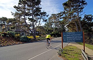
17-Mile Drive is a scenic road through Pebble Beach and Pacific Grove on the Monterey Peninsula in California, much of which hugs the Pacific coastline and passes famous golf courses, mansions and scenic attractions, including the Lone Cypress, Bird Rock and the 5,300-acre Del Monte Forest of Monterey Cypress trees.

Carmel Valley is an unincorporated community in Monterey County, California, United States. The term "Carmel Valley" generally refers to the Carmel River watershed east of California State Route 1, and not specifically to the smaller Carmel Valley Village. For statistical purposes, the United States Census Bureau has defined Carmel Valley as a census county division (CCD), with an area covering approximately 189 square miles (490 km2). At the time of the 2020 census the CCD population was 6,189. In November 2009, a majority of residents voted against incorporation.
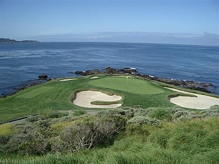
Pebble Beach Golf Links is a public golf course on the west coast of the United States, located in Pebble Beach, California.

Laws is an unincorporated community in Inyo County, California. Laws is located 4 miles (6.4 km) northeast of Bishop on U.S. Route 6, towards the Nevada state line.

Glenwood, California, is an unincorporated area of Santa Cruz County. It is located at coordinates 37°6′29″N121°59′8″W, and is 891 feet above sea level.

Highland Springs is a set of springs which was turned into a resort in the 19th century in Lake County, California. The resort grew to be able to accommodate 200 people, attracted by the curative powers of the mineral waters and the lovely mountain scenery. In the 1920s its popularity waned, the hotel was partly burned, and it passed through various hands before the county claimed eminent domain, bought the property, and flooded it with the Highland Springs Reservoir. The reservoir is surrounded by the Highland Springs Recreation Area, managed by the county.
Robles del Rio, sometimes spelled as Robles Del Rio, is an unincorporated community in Monterey County, California. It is located west of the Carmel River in Carmel Valley, at an elevation of 597 ft (182 m). For statistical purposes, the community is part of the Carmel Valley Village census-designated place.

Samuel Finley Brown Morse was an American environmental conservationist and the developer of Pebble Beach. He was known as the Duke of Del Monte and ran his company from the 1919 until his death in 1969. Originally from the eastern United States, Morse moved west and fell in love with the Monterey Peninsula, eventually owning and preserving vast acreage while also developing golf courses and The Lodge at Pebble Beach.

The Pacific Improvement Company (PIC) was a large holding company in California and an affiliate of the Southern Pacific Railroad. It was formed in 1878, by the Big Four, who were influential businessmen, philanthropists and railroad tycoons who funded the Central Pacific Railroad, (C.P.R.R.). These men were: Leland Stanford (1824–1893), Collis Potter Huntington (1821–1900), Mark Hopkins (1813–1878), and Charles Crocker (1822–1888). They owned the company, each with 25% interest. Archived records date from 1869 to 1931.
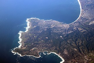
The Monterey Peninsula anchors the northern portion on the Central Coast of California and comprises the cities of Monterey, Carmel, and Pacific Grove, and the resort and community of Pebble Beach.
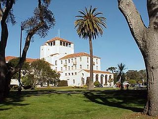
The Hotel Del Monte was a large resort hotel in Monterey, California, from its opening in 1880 until 1942. It was one of the finest luxury hotels in North America. During World War II, it closed and the building was leased to the United States Navy. It first was used by the Navy as a school where enlisted men spent the second, third, and fourth months of an 11-month course being trained as electronic technicians. Later the Hotel Del Monte became the Naval Postgraduate School. Today, the building is named Herrmann Hall. It contains school administrative offices and the Navy Gateway Inns and Suites, a hotel.

Julian Pitzer Graham, nicknamed “Spike” was an American photographer. His legacy is over 40,000 photographs and negatives of many famous people that visited and lived on the Monterey Peninsula. Between 1924 and 1963, Graham, was an independent, official photographer for Del Monte Properties, which is known today as the Pebble Beach Company. His photographs appeared in magazines such as Life and National Geographic, national and international newspapers, books, fashion layouts, and promotional material used for advertising the Pebble Beach Company. Graham's photographs chronicle the history of the Monterey Peninsula which includes the creation of Cypress Point Golf Club, Pebble Beach Golf Links and the Monterey Peninsula Country Club. His career lasted 39 years until his death at his home in Carmel Valley, California on March 13, 1963.

El Carmelo Hotel was Pacific Grove's first hotel, opened to guests on May 20, 1887. It was sometimes called the sister of the Hotel Del Monte. It was located on Lighthouse Avenue between Fountain and Grand Avenues, Pacific Grove and owned by the Pacific Improvement Company (PIC). In 1907, the name of the hotel changed to the Pacific Grove Hotel. In 1917, the PIC decided to dismantle it and use the wood in the reconstruction of The Lodge at Pebble Beach, California that had burned down on December 17, 1917. The empty block was sold to W. R. Holman in 1919 to open the Holman Department Store.

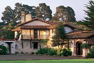
The Lodge at Pebble Beach is a historic American hotel and clubhouse overlooking the Carmel Bay in Pebble Beach, California. Opened in 1919, the property, operated by Pebble Beach Resorts.

Del Monte station was a passenger railroad depot for Del Monte, Monterey, California. The station was named after the former resort Hotel Del Monte, now the Naval Postgraduate School. The station was completed in 1880 on Del Monte Avenue, next to the hotel. Operating under the Southern Pacific Railroad, the station was in use until the cancellation of the Del Monte train route on April 30, 1971, when Amtrak took control of passenger rail services across the United States.

