Related Research Articles

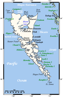
Haida Gwaii is an archipelago approximately 45–60 km (28–37 mi) off the northern Pacific coast of Canada. The islands are separated from the mainland to the east by the shallow Hecate Strait. Queen Charlotte Sound lies to the south, with Vancouver Island beyond. To the north, the disputed Dixon Entrance separates Haida Gwaii from the Alexander Archipelago in the U.S. state of Alaska.
Graham Island is the largest island in the Haida Gwaii archipelago, lying off the coast of British Columbia, Canada. It is separated only by a narrow channel from the other principal island of the group, Moresby Island. It has a population of 4,475, an area of 6,361 km2 (2,456 sq mi), and is the 101st largest island in the world and Canada's 22nd largest island.

Skidegate is a Haida community in Haida Gwaii in British Columbia, Canada. It is located on the southeast coast of Graham Island, the largest island in the archipelago, and is approximately 50 kilometres (31 mi) west of mainland British Columbia across Hecate Strait.

Masset, formerly Massett, is a village in Haida Gwaii in British Columbia, Canada. It is located on Masset Sound on the northern coast of Graham Island, the largest island in the archipelago, and is approximately 50 km (31 mi) west of mainland British Columbia. It is the primary western terminus of Trans-Canada Highway 16 and is served by Masset Airport, with flights to Vancouver and Prince Rupert. During the maritime fur trade of the early 19th century, Masset was a key trading site. It was incorporated as a village municipality on May 11, 1961.

Port Clements is an incorporated village situated at the east end of Masset Inlet in Haida Gwaii off the coast of the Province of British Columbia in Canada. Known as Gamadiis in HlG̱aagilda X̱aayda kil, it is one of seven village sites that flourished in the rich waters at the mouth of Yakoun River, where an estuary shelters nine Pacific salmonid species and many kinds of birds. Founded by Eli Tingley in 1907, it was once known under the name Queenstown, but renamed to Port Clements in 1914 after Herb S. Clements, the local MP at the time, when the name "Queenstown" duplicated and therefore became unusable for the post office.
The Squamish Nation, Sḵwx̱wú7mesh Úxwumixw in Sḵwx̱wú7mesh Sníchim, is an Indian Act government originally imposed on the Squamish (Sḵwx̱wú7mesh) by the Federal Government of Canada in the late 19th century. The Squamish are Indigenous to British Columbia, Canada. Their band government comprises 16 elected councillors, serving four-year terms, with an elected band manager. Their main reserves are near the town of Squamish, British Columbia and around the mouths of the Capilano River, Mosquito Creek, and Seymour River on the north shore of Burrard Inlet in North Vancouver, British Columbia.
Ḵwiḵwa̱sut'inux̱w Ha̱xwa'mis, formerly the Kwicksutaineuk-ah-kwa-mish First Nation is a First Nations band government based on northern Vancouver Island in British Columbia, Canada, in the Queen Charlotte Strait region. It is a member of the Musgamagw Tsawataineuk Tribal Council, along with the ‘Namgis First Nation and the Tsawataineuk First Nation. The Kwikwasut'inuxw and Haxwa'mis are two of the many subgroups of the peoples known as Kwakwaka'wakw, which means "speakers of Kwak'wala", their language, and were combined into one band by the Department of Indian and Northern Affairs.

Tow Hill is a large isolated volcanic plug located 21 km (13 mi) east of Masset on the north end of the Naikoon Peninsula of northeast Graham Island in Haida Gwaii, British Columbia, Canada, east of McIntyre Bay and near the mouth of the Hiellen River, which is the site of Hiellen, a now-abandoned Haida village and of the Hiellen Indian Reserve No. 2, on the site of that village. Formerly Tow Hill Provincial Park, it is now part of Naikoon Provincial Park, which covers most of the northeastern flatland of Graham Island.
The Yakoun River is the largest river on Haida Gwaii, off the North Coast of British Columbia, Canada. Estimated to be 55 to 60 kilometres in length, it is located on Graham Island, the northernmost and largest of the archipelago, and runs in a twisting course generally northwards from Yakoun Lake, which lies near the island's south-central region, just northwards over Slatechuck Mountain from Skidegate Inlet, entering saltwater at Masset Inlet, a large saltwater bay located in the heart of the island.

Masset Inlet is a large saltwater bay located in the heart of the lowland of northern Graham Island, the northernmost and largest island of the Haida Gwaii islands on the North Coast of British Columbia, Canada. It is fed by several rivers, the largest of which is the Yakoun River, and is connected to the open sea of the Dixon Entrance by the narrow Masset Sound and Masset Harbour, which opens onto McIntyre Bay. The communities of Port Clements and Sewall are located on the shores of Masset Inlet. The community of Juskatla is located on Juskatla Inlet, the largest of Masset Inlet's arms. There are several islands in the inlet, the largest of which is Kumdis Island, at the inlet's egress to Masset Sound and just north of Port Clements. Masset Inlet helps form the isthmus of the Naikoon Peninsula.

Masset Sound is a 38-kilometre (24 mi) saltwater inlet on Graham Island, the largest and northernmost of the Haida Gwaii islands of the North Coast of British Columbia, Canada, connecting Masset Inlet in the island's interior with the open sea via Masset Harbour and McIntyre Bay to the Dixon Entrance. It averages 1.5 kilometres (0.93 mi) in width and is less than 750 metres (2,460 ft) width in certain spots. The town of Masset is located on the east bank of Masset Sound's northern end.
Sewall, sometimes incorrectly spelled Sewell, is an unincorporated locality located on the north shore of Masset Inlet, on Graham Island in the Haida Gwaii archipelago off the North Coast of British Columbia, Canada. It is located 21 miles up Masset Inlet.
Old Massett Village Council is a band government of the Haida people, located at Old Massett, British Columbia, Canada, in the Queen Charlotte Islands, also known as Haida Gwaii. Old Massett Village Council is one of two band governments forming the Haida Tribal Society, the other is the Skidegate Band Council. The main governing body of the Haida people is the Council of the Haida Nation.

Old Massett, named G̱aw in X̱aad kíl, is an Aboriginal Canadian village on Graham Island in Haida Gwaii, British Columbia. It lies on the east side of Masset Sound close to the town of Masset; the area of land it is on is legally designated Masset Indian Reserve No. 1, or Masset 1. The original name of the settlement was Uttewas, meaning "white-slope village" in the Haida language. It is populated by Haida people of both Ḵuustak, the Eagle matrilineage, and Ḵayx̱al, the Raven matrilineage. The town is administered by the Old Massett Village Council. Its population has fluctuated over the last one hundred and fifty years; smallpox drastically reduced its numbers in the late 1800s, but in 1968, it had over 1,000 people and was the largest village in Haida Gwaii. In 2009, the Village Council counted 2,698 band members in the area; the 2016 census counted 555 living at the Old Massett townsite.
Maude Island is an island in the Haida Gwaii archipelago of the North Coast region of British Columbia, Canada. It is located within Skidegate Inlet, a large saltwater inlet within Graham Island. It is the larger of two islands in British Columbia by that name, the other being a small islet offshore from Nanoose Bay and Lantzville on southeastern Vancouver Island.
Skidegate Inlet is an inlet on the east coast of the Haida Gwaii archipelago of the North Coast of British Columbia, Canada. It is the easternmost of a series of waterways separating Graham Island to the north from Moresby Island to the south. The community of Skidegate is located on its northern shore, on Graham Island.
The Ain River is a river on Graham Island in the Haida Gwaii archipelago of the North Coast region of British Columbia, Canada, flowing southeast into Masset Inlet.
Jedway is a landing and erstwhile settlement and mining camp on Harriet Harbour, part of Skincuttle Inlet, on the east coast of Moresby Island in Haida Gwaii, British Columbia, Canada. Jedway was once a hub for mines in the area during a mining boom on South Moresby, including mines at Ikeda and Lockeport, though a mine at the Jedway iron-magnetite deposit, known as the Jessie showings, did not open until 1961. In the earlier period, Jedway had been the "capital" of the Queen Charlotte Islands until that (the headquarters of the provincial Gold Commissioner, E.M. Sandilands, whose position carried with it all the functions of and powers of government, to Queen Charlotte City in 1910. A 1908 in The Ledge, a mining newspaper based in Greenwood, said "there is room for another hotel in Jedway". Jedway remained a local service centre after that, however, with two Chinese sentenced to months-long imprisonment being relocated there from Queen Charlotte City in 1912 indicating the presence of jail facilities there.
Kiusta located on Haida Gwaii is the oldest Northern Haida village: and the site of first recorded contact between the Haida and Europeans in 1774. Haida lived in this village for thousands of years, due to the sheltered nature of its location it was used for boats offloading, especially in rough waters. Kiusta is one of the oldest archeological sites of human use in British Columbia, and continues to be a site for cultural revitalisation.

The peoples of Haida Gwaii were a fiercely independent people and rejected outside control. Since first being sighted by Europeans in 1774 by Juan Pérez, at Langara Island there were many police actions against the Haida. This continued until the population was decimated in the mid-19th century, with a population of tens of thousands being reduced by smallpox to under a thousand. Hostile colonial administration further reduced the population to 588 by 1915.
References
Coordinates: 54°01′00″N132°08′00″W / 54.01667°N 132.13333°W
| This article related to a river in the Coast of British Columbia, Canada is a stub. You can help Wikipedia by expanding it. |