| Department overview | |
|---|---|
| Jurisdiction | Queensland |
| Headquarters | 1 William Street, Brisbane |
| Minister responsible |
|
| Website | resources.qld.gov.au |
The Department of Resources is a department of the Queensland Government in Australia. The department is responsible for regulating mining, and resources in the state. [1]
The department's headquarters are at 1 William Street, Brisbane.
The department is the responsibility of the Minister for Resources Scott Stewart. The department works across three key areas:
These responsibilities include place naming in Queensland. The department also operates the Museum of Lands, Mapping and Surveying. [2]

North Stradbroke Island, colloquially Straddie or North Straddie, is an island that lies within Moreton Bay in the Australian state of Queensland, 30 kilometres (19 mi) southeast of the centre of Brisbane. Originally there was only one Stradbroke Island but in 1896 it split into North Stradbroke Island and South Stradbroke Island separated by the Jumpinpin Channel. The Quandamooka people are the traditional owners of North Stradbroke island.
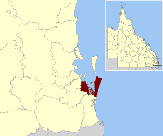
Redland City, better known as the Redlands and formerly known as Redland Shire, is a local government area and a part of the Brisbane metropolitan area in South East Queensland, Australia. With a population of 159,222 in June 2021, the city is spread along the southern coast of Moreton Bay, covering 537.2 square kilometres (207.4 sq mi). Its mainland borders the City of Brisbane to the west and north-west, and Logan City to the south-west and south, while its islands are situated north of the City of Gold Coast.

Croydon is an outback town and locality within the Shire of Croydon in Queensland, Australia. It is a terminus for the Normanton to Croydon railway line, which operates the Gulflander tourist train. At the 2016 census, Croydon had a population of 258 people.

Geoscience Australia is an agency of the Australian Government. It carries out geoscientific research. The agency is the government's technical adviser on all aspects of geoscience, and custodian of the geographic and geological data and knowledge of the nation.
The Department of Mines and Petroleum was a department of the Government of Western Australia until it was superseded by the Department of Mines, Industry Regulation and Safety on 1 July 2017. The department was formed on 1 January 2009, out of the former Department of Industry and Resources and Department of Consumer and Employment Protection, which were split into three new departments, the Department of Mines and Petroleum, the Department of State Development and the Department of Commerce.

The Carmichael coal mine is a coal mine in Queensland, Australia which produced its first shipment of coal in December 2021.

The Museum of Lands, Mapping and Surveying is a museum at 317 Edward Street, Brisbane, Queensland, Australia. It collects and exhibits material relating to the surveying of Queensland and the maps created. It is a sub-branch of the Queensland Museum. It actively digitises and makes available historic maps and aerial imagery under open licences.

Wellington County, Queensland is a cadastral division of Queensland and a County of remote western Queensland.
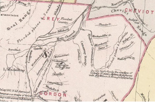
Gordon County is a cadastral division of Queensland, Australia and a County of the South Gregory District of remote western Queensland. The county is divided into civil parishes.

Bulgroo County is a cadastral division of Queensland and a County of the South Gregory District of remote western Queensland. The county is divided into civil parishes.

Cooper County is a cadastral division of Queensland and a County of the South Gregory District of remote western Queensland. The county is divided into civil parishes.
Cameron County, Queensland is a County of Queensland in Australia, in the South Gregory District Land District.

Kendall County is a County of Queensland located at 13.683°S 141.967°E on the Cape York Peninsula in remote far north of Queensland, Australia.
Gowan County, Queensland is a cadastral division of Queensland and a County of the Warrego Land District of southwestern Queensland in Australia.

Ayrshire County, Queensland is one of the 318 counties of Queensland, Australia. The county came into existence in the 19th century, and on 8 March 1901, the Governor of Queensland issued a proclamation legally dividing Queensland into counties under the Land Act 1897. Like all counties in Queensland, it is a non-functional administrative unit, that is used mainly for the purpose of registering land titles. From 30 November 2015, the government no longer referenced counties and parishes in land information systems however the Museum of Lands, Mapping and Surveying retains a record for historical purposes.
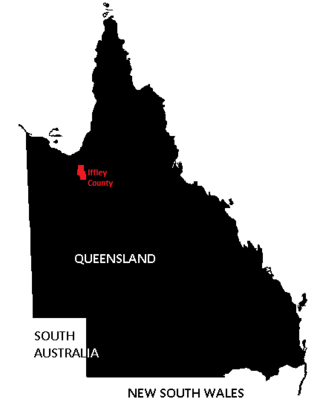
Iffley County, Queensland is one of the 318 counties of Queensland, Australia. The county is divided into civil parishes.

Rodney County is one of the 318 counties of Queensland, Australia. The county is divided into civil parishes.
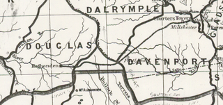
Douglas County, Queensland is one of the 318 counties of Queensland, Australia. The county is divided into civil parishes. The county came into existence in the 19th century, and on 8 March 1901, the Governor of Queensland issued a proclamation legally dividing Queensland into counties under the Land Act 1897. Like all counties in Queensland, it is a non-functional administrative unit, that is used mainly for the purpose of registering land titles. From 30 November 2015, the government no longer referenced counties and parishes in land information systems however the Museum of Lands, Mapping and Surveying retains a record for historical purposes.

Eyre County, Queensland is a cadastral division of North Gregory District of Western Queensland and a County of Queensland, Australia.
Yappar County, Queensland is a cadastral division of Burke District of northern Queensland and a County of Queensland, Australia.
| International | |
|---|---|
| National | |
| Other | |
| | This Australian government-related article is a stub. You can help Wikipedia by expanding it. |