Related Research Articles

The Peak District is an upland area in central-northern England, at the southern end of the Pennines. Mostly in Derbyshire, it extends into Cheshire, Greater Manchester, Staffordshire, West Yorkshire and South Yorkshire. It is subdivided into the Dark Peak, moorland dominated by gritstone, and the White Peak, a limestone area with valleys and gorges. The Dark Peak forms an arc on the north, east and west of the district, and the White Peak covers central and southern areas. The highest point is Kinder Scout. Most of the area is within the Peak District National Park, a protected landscape designated in 1951.

Derbyshire is a ceremonial county in the East Midlands of England. It borders Greater Manchester, West Yorkshire, and South Yorkshire to the north, Nottinghamshire to the east, Leicestershire to the south-east, Staffordshire to the south and west, and Cheshire to the west. Derby is the largest settlement, and Matlock is the county town.

Mam Tor is a 517 m (1,696 ft) hill near Castleton in the High Peak of Derbyshire, England. Its name means "mother hill", so called because frequent landslips on its eastern face have resulted in a multitude of "mini-hills" beneath it. These landslips, which are caused by unstable lower layers of shale, also give the hill its alternative name of Shivering Mountain.

Castleton is a village and civil parish in the High Peak district of Derbyshire, England, at the western end of the Hope Valley on the Peakshole Water, a tributary of the River Noe, between the Dark Peak to the north and the White Peak to the south. The population was 642 at the 2011 Census.

Hope is a village and civil parish in the Derbyshire Peak District, in England. The population at the 2011 Census was 864. It lies in the Hope Valley, at the point where Peakshole Water flows into the River Noe. To the north, Win Hill and Lose Hill stand either side of the Noe.

Matlock is the county town of Derbyshire, England. It is in the south-eastern part of the Peak District, with the National Park directly to the west. The spa resort of Matlock Bath is immediately south of the town as well as Cromford lying further south still. The civil parish of Matlock Town had a population in the 2021 UK census of 10,000.

Wirksworth is a market town and civil parish in the Derbyshire Dales district of Derbyshire, England. Its population of 4,904 in the 2021 Census was estimated at 5,220 in 2023. Wirksworth contains the source of the River Ecclesbourne. The town was granted a market charter by Edward I in 1306 and still holds a market on Tuesdays in the Memorial Gardens. The parish church of St Mary's is thought to date from 653. The town developed as a centre for lead mining and stone quarrying. Many lead mines were owned by the Gell family of nearby Hopton Hall.

The Hope Valley is a rural area centred on the village of Hope, Derbyshire, in the Peak District in the northern Midlands of England.

Cromford is a village and civil parish in Derbyshire, England, in the valley of the River Derwent between Wirksworth and Matlock. It is 17 miles (27 km) north of Derby, 2 miles (3.2 km) south of Matlock and 1 mile (1.6 km) south of Matlock Bath. It is first mentioned in the 11th-century Domesday Book as Crumforde, a berewick of Wirksworth, and this remained the case throughout the Middle Ages. The population at the 2011 Census was 1,433. It is principally known for its historical connection with Richard Arkwright and the nearby Cromford Mill, which he built outside the village in 1771. Cromford is in the Derwent Valley Mills World Heritage Site.

The history of Derbyshire can be traced back to human settlement since the last Ice Age, over 10,000 years ago. The county of Derbyshire in England dates back to the 11th century.

The Limestone Way is a waymarked long-distance footpath in Derbyshire, England. It runs for 46 miles (74 km) through the White Peak of the Peak District National Park, from Castleton south to Rocester over the county boundary into Staffordshire. The trail is named for the limestone scenery along its route. It was devised by Brian Spencer of Matlock Rotary Club and developed and opened in 1986 by the West Derbyshire District Council. It originally ran to Matlock, but was extended to its current, longer route in 1992 to join up with the Staffordshire Way.

Robin Hood's Stride is a rock formation on the Limestone Way in Derbyshire close to the village of Elton. The nearest town is Bakewell, to the north. It consists of gritstone boulders deeply seamed by water flows. The two "pinnacles" are Weasel pinnacle and Inaccessible pinnacle. An ancient road, possibly prehistoric or Roman, the Derbyshire Portway, passes close to the outcrop. Nearby is Nine Stones Close, a four-stone circle, and, at Cratcliffe Tor, a rock shelter known as the Hermit's Cave, containing a crucifix carving dated stylistically to the 13th or 14th century. The name Robin Hood's stride comes from the 14th-century legend that Robin Hood jumped between the chimneys of the rock formation.

The A625 is a rural road which runs through north Derbyshire and the Peak District in England.
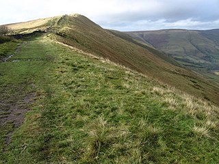
Rushup Edge is a ridge in the Derbyshire Peak District of England. The ridge's highest point is Lord's Seat at 550 m (1,804 ft), while Mam Tor lies beyond its eastern end, at the western end of the Great Ridge.

Shottle and Postern is a civil parish within the Amber Valley district, which is in the county of Derbyshire, England. Sparsely built up with much rural expanse, its population was 270 residents in the 2021 census. The parish is 120 miles (190 km) north west of London, 9 miles (14 km) north west of the county town of Derby, and 2+3⁄4 miles (4.4 km) equidistant of the nearest market towns of Belper and Wirksworth. It shares a boundary with the parishes of Alderwasley, Ashleyhay, Belper, Hazelwood, Idridgehay and Alton, Turnditch and Windley.

Navio Roman fort overlooks a tight bend of the River Noe at Brough-on-Noe near Hope, Derbyshire, in England. Navio fort and vicus is a Scheduled Monument.

Harthill Moor is a small upland area in the Derbyshire Peak District of central and northern England, lying between Matlock and Bakewell near the villages of Birchover and Elton. The moor is within the southern portion of Harthill civil parish. Its highest point is 272 metres (892 ft) above sea level. The River Bradford flows along the northern edge of the moor past Youlgreave and into the River Lathkill at Alport. Harthill Moor is a rich prehistoric landscape with several protected scheduled monuments.

Steeple House railway station was a railway station on the Cromford and High Peak Railway serving the market town of Wirksworth and village of Middleton-by-Wirksworth in Derbyshire, England. It was located on the former line between High Peak Junction near Cromford and the Parsley Hay near Buxton.

Harthill is a civil parish within the Derbyshire Dales district, in the county of Derbyshire, England. Largely rural, along with parts of the neighbouring Youlgreave parish, in the 2021 census Harthill had a population of 48. It is 128 miles (206 km) north west of London, 18+1⁄2 miles (29.8 km) north west of the county city of Derby, and 3 miles (4.8 km) south east of the nearest market town of Bakewell. Harthill is wholly within the Peak District national park, and touches the parishes of Birchover, Elton, Gratton, Nether Haddon, Stanton and Youlgreave. There are eight listed buildings in Harthill.

Ivonbrook Grange is a civil parish within the Derbyshire Dales district, in the county of Derbyshire, England. Largely rural, Ivonbrook Grange's population is reported with the population of neighbouring parishes for a total of 180 residents in 2011. It is 130 miles (210 km) north west of London, 15 miles (24 km) north west of the county city of Derby, and 3+1⁄2 miles (5.6 km) south west of the nearest market town of Matlock. Ivonbrook Grange is wholly within the Peak District national park on its southern edge, and shares a border with the parishes of Aldwark, Bonsall, Brassington, Ible as well as Winster. There is one listed structure in Ivonbrook Grange.
References
- 1 2 "Derbyshire Portway". derbyshire-peakdistrict.co.uk. Retrieved 7 October 2017.
- ↑ "Wirksworth Archaeological Society Portway Report". www.wirksworthromanproject.co.uk. Retrieved 7 October 2017.
- ↑ Bailey, Stephen. The Old Roads of Derbyshire : walking into history : the Portway and beyond. Troubador Publishing Ltd. ISBN 978-1789018431.
- ↑ "Derbyshire Portway". The Long Distance Walkers Association. Retrieved 7 October 2017.