Derrinallum

Last updated

Derrinallum
Victoria
DerrinallumTrees.JPG
Avenue on main street
Australia Victoria Corangamite Shire location map.svg
Red pog.svg
Derrinallum
Coordinates 37°57′0″S143°13′0″E / 37.95000°S 143.21667°E / -37.95000; 143.21667 Coordinates: 37°57′0″S143°13′0″E / 37.95000°S 143.21667°E / -37.95000; 143.21667
Population557 (2006 census) [1]
Postcode(s) 3325
Location
LGA(s) Corangamite Shire
State electorate(s) Polwarth
Federal division(s) Wannon

Derrinallum is a town in Victoria, Australia, located on the Hamilton Highway, in the Corangamite Shire. The town is the centre for the surrounding farming community and lies at the foot of Mount Elephant. Mount Elephant is a 380 m-high conical breached scoria cone formed by an dormant volcano.

Contents

At the 2001 census, Derrinallum had a population of 266. [2] At the 2016 census, Derrinallum had a population of 557.

History

The Djargurd Wurrong people are the traditional Aboriginal owners of the Derrinallum district. [3] The Djargurd Wurrong people consist of twelve clans that traditionally shared a common language and family ties, but each clan had its own territory. [4] For tens of thousands of years they successfully occupied the area as a semi-nomadic hunter gatherer society. [5] During European colonisation in the 1830s, Mount Elephant was located within the territory of the clan Teerinyillum Gundidj. [6] One known Aborigonal man from the Derrinallum clan (or Teerinyillum Gundidj) was known as "King Tom of the Mount Elephant tribe". [7] He was painted by Robert Hawker Dowling in 1856 (National Library of Australia). [8] King Tom was later photographed at Coranderrk [9] Aboriginal Mission in 1877 [10] by the photograger Fred Kruger (1831-1888).

Colonial exploration of the Derrinallum district began in 1837 by the "Derwent Company". The company comprised Messers, Learmonth, Fisher, Mercer, and Swanston. They headed north from Lake Corangamite, climbed the volcanic cone of Mount Elephant, and named the mountain "Elephant Hill". [11] The first official overland trip from Geelong to Portland was led by Fyans and Smythe in 1839, where Fyans recorded "we bend our steps across to Teron Allum Hill or elpephant". On the same trip Smythe recorded that June 2 they "started early for Lake Colac... and the native pointed out a hill to which we travelled, the name of the Mount is Terrinallum" [12] Derrinallum was also known as The Swamp by early colonial settlers. [13] The local indigenous tribe called the locality Djerrinallum meaning sea swallow or tern, a species that used to flock to the area in abundance. [14]

An application to build a general store set the ball rolling with the townsite being surveyed in 1866. In 1867 the village of Tooliorook was proclaimed and the first land sales were held in the nearby town of Camperdown. The Post Office opened on 7 December 1868 but was named Tooliorook until 1873. [15] Unhappy with the name of the budding township the residents applied for a name change. The options were Derrinallum, Tarrinallum, Dunwall or Dunstone.. The post office changed its name to Derrinallum in 1873 to match the new name of the town. Growth of the town was slow, by the time of Federation there were only seven dwellings in the town. The town's war memorial doesn't have any names from WW1. The arrival of the railway in 1913 preceded the soldier settlements of the 1920s. The arrival of the return soldiers lead to the formation of the RSL and the placement of the war memorial. Prior to WW2 the population of the town jumped from 69 to 155 residents.

On 14 January 1944, a bushfire that started in Vite Vite aided by strong northerly winds destroyed the town. Only 12 buildings remained standing after the fire. The devastation and subsequent rebuilding the town is notable for all the post war style architecture.

More land was available for soldiers returning from WW2, these soldiers with their families help swell the numbers in the district and aided the growth in the town and the services it could provide..

Community

Derrinallum features a FoodWorks supermarket, which includes a hardware store, nursery and newsagency. Also within the town are a post office, a fish and chip shop (Derri Takeaway), a pub, a motel, a Shell service station, two mechanics, a library, a Red Cross shop, a rural supplies business and a cafe. The town had an ANZ Bank until it closed in November 2014.

Derrinallum P12 College is a co-educational state school in the town. The school is constantly having new students arrive and settle into the community.

The main street also hosts a war memorial, history rooms and community information centre called DISC, which is also the local Centrelink resource centre.

Over summer, running from October to March, the town hosts a country farmer's market on the third Sunday of the month. [16]

Close to town are the Deep Lake and Lake Ettrick, both of these lakes host a variety of sporting and social activities.

The local Country Fire Authority (CFA) in Derrinallum has a variety of equipment, including two fire trucks. It is part of the CFA Lismore group and District 06.

The town, in conjunction with neighbouring township Lismore, has an Australian Rules football team, Lismore-Derrinallum, competing in the Mininera & District Football League.

Crime

On 12 April 2014, Derrinallum became the centre of Australia's biggest explosives clean up, after a local, Glenn Sanders, (also known as 'The Colonel'), an explosives expert and professional mechanic, detonated explosives in his house. Two Police officers were seriously hurt. The blast rocked the town and was heard over 15 km away. The incident left Derrinallum isolated for a number of weeks, including the busy Easter and Anzac Day weekends. [17] [18]

Related Research Articles

<span class="mw-page-title-main">Terang</span> Town in Victoria, Australia

Terang is a town in the Western District of Victoria, Australia. The town is in the Shire of Corangamite and on the Princes Highway 212 kilometres (132 mi) south west of the state's capital, Melbourne. At the 2006 census, Terang had a population of 1,824. At the 2001 census, Terang had a population of 1,859. The population of Terang has since risen according to the 2011 Census; the population is now 2,348, of which 1,155 are male and 1,193 are female, with the median age being 44.

<span class="mw-page-title-main">Halls Gap</span> Town in Victoria, Australia

Halls Gap is a town in Victoria, Australia. It is located on Grampians Road, adjacent to the Grampians National Park, in the Shire of Northern Grampians local government area. The town is set in the Fyans Valley at the foot of the Wonderland and Mount William ranges. At the 2016 census Halls Gap had a population of 430. The approximate driving time from Melbourne is 3 hours.

<span class="mw-page-title-main">Foster Fyans</span> Australian politician

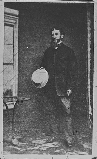
Foster Fyans was an Irish military officer, penal colony administrator and public servant. He was acting commandant of the second convict settlement at Norfolk Island, the commandant of the Moreton Bay penal settlement at Brisbane, the first police magistrate at Geelong, and commissioner of crown lands for the Portland Bay pastoral district in the Port Phillip District of New South Wales. He is the great-great-grandfather of actor Sam Neill.

<span class="mw-page-title-main">Taungurung</span>

The Taungurung people, also spelt Daung Wurrung, are an Aboriginal people who are one of the Kulin nations in present-day Victoria, Australia. They consist of nine clans whose traditional language is the Taungurung language.

The Wathaurong nation, also called the Wathaurung,Wadawurrung and Wadda Wurrung, are an Aboriginal Australian people living in the area near Melbourne, Geelong and the Bellarine Peninsula in the state of Victoria. They are part of the Kulin alliance. The Wathaurong language was spoken by 25 clans south of the Werribee River and the Bellarine Peninsula to Streatham. The area they inhabit has been occupied for at least the last 25,000 years.

<span class="mw-page-title-main">Camperdown, Victoria</span> Town in Victoria, Australia

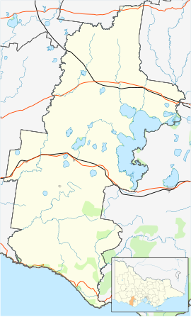
Camperdown is a town in southwestern Victoria, Australia, 190 kilometres (120 mi) west of the state capital, Melbourne. At the 2016 census, Camperdown had a population of 3,369.

<span class="mw-page-title-main">Joseph Gellibrand</span> Australian politician

Joseph Tice Gellibrand was the first Attorney-General of the British colony of Van Diemen's Land where he gained notoriety with his attempts to establish full rights of trial by jury. He became an integral part of the Port Phillip Association, producing the Batman Treaty in an attempt to obtain extensive land-holdings from the local Aboriginal people around Port Phillip. He was also later part of an ill-fated expedition into the region west of Geelong where he disappeared and was assumed to have been killed by Aboriginal people in the Otway Range.

<span class="mw-page-title-main">Lismore, Victoria</span> Town in Victoria, Australia

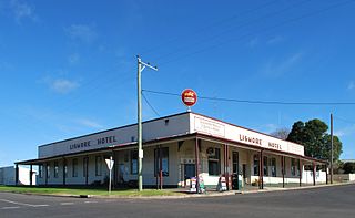
Lismore is a town in Victoria, Australia, located on the Hamilton Highway 170 kilometres (106 mi) west of Melbourne. It is part of the Corangamite Shire local government area. At the 2016 census, Lismore had a population of 420.

The Gunditjmara or Gunditjamara, also known as Dhauwurd Wurrung, are an Aboriginal Australian people of southwestern Victoria. They are the traditional owners of the areas now encompassing Warrnambool, Port Fairy, Woolsthorpe and Portland. Their land includes much of the Budj Bim heritage areas. The Kerrup Jmara are a clan of the Gunditjmara, whose traditional lands are around Lake Condah. The Koroitgundidj are another clan group, whose lands are around Tower Hill.

<span class="mw-page-title-main">Mount Elephant</span> Mountain in Victoria, Australia

Mount Elephant is a 380-metre-high (1,250 ft) conical breached scoria cone formed by a dormant volcano, located 1 km from the town of Derrinallum in southwestern Victoria, Australia. It is a prominent landmark that forms the eastern gateway to the Kanawinka Geopark from the Hamilton Highway at Derrinallum.

<span class="mw-page-title-main">Woady Yaloak River</span> Perennial river in Victoria, Australia

The Woady Yaloak River is a perennial river of the Corangamite catchment, located in the Western District Lakes region of the Australian state of Victoria.

<span class="mw-page-title-main">Shire of Hampden</span> Local government area in Victoria, Australia

The Shire of Hampden was a local government area about 200 kilometres (124 mi) west-southwest of Melbourne, the state capital of Victoria, Australia. The shire covered an area of 2,620.91 square kilometres (1,011.9 sq mi), and existed from 1857 until 1994.

The Convincing Ground Massacre was a massacre of the Indigenous Gunditjmara people Kilcarer gundidj clan by British settler whalers based at Portland Bay in South-Eastern Australia. It was part of the wider Eumeralla Wars between the British colonisers and Gunditjmara. Tensions between the two groups had been building since the establishment of the town as a whaling station some five years previously, however, around 1833 or 1834, a dispute over a beached whale caused events to escalate.

<span class="mw-page-title-main">County of Hampden, Victoria</span> Cadastral in Victoria, Australia

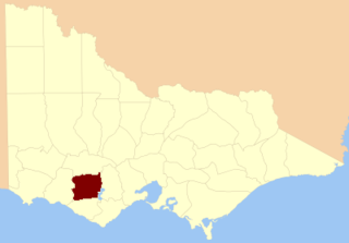
The County of Hampden is one of the 37 counties of Victoria which are part of the cadastral divisions of Australia, used for land titles. The county is in the Western District of Victoria bounded by Lake Corangamite in the east and the Hopkins River in the west. In the north and south the county was bounded approximately by the existing roads, now the Glenelg Highway and the Princes Highway. Larger towns include Terang and Skipton. The county was proclaimed in 1849.

The Djargurd Wurrong are Aboriginal Australian people of the Western district of the State of Victoria, and traditionally occupied the territory between Mount Emu Creek and Lake Corangamite.

Murdering Gully, formerly known as Puuroyup to the Djargurd Wurrung people, is the site of an 1839 massacre of 35–40 people of the Tarnbeere Gundidj clan of the Djargurd Wurrung in the Camperdown district of Victoria, Australia. It is a gully on Mount Emu Creek, where a small stream adjoins from Merida Station.

The Gulidjan people, also known as the Kolakngat, or Colac tribe, are an Aboriginal Australian tribe whose traditional lands cover the Lake Colac region of the state of Victoria, Australia. They occupied the grasslands, woodlands, volcanic plains and lakes region east of Lake Corangamite, west of the Barwon River and north of the Otway Ranges. Their territory bordered the Wathaurong to the north, Djargurd Wurrung to the west, Girai Wurrung to the south-west, and Gadubanud to the south-east.

<span class="mw-page-title-main">Girai wurrung</span> Aboriginal Australian people of present-day western Victoria

The Girai wurrung, also spelt Kirrae Wuurong and Kirrae Whurrung, are an Aboriginal Australian people who traditionally occupied the territory between Mount Emu Creek and the Hopkins River up to Mount Hamilton, and the Western Otways from the Gellibrand River to the Hopkins River. The historian Ian D. Clark has reclassified much of the material regarding them in Norman Tindale's compendium under the Djargurd Wurrung, a term reflecting the assumed pre-eminence of one of their clans, the Jacoort/Djargurd.

<span class="mw-page-title-main">Yarrowee River</span> Perennial river in Victoria, Australia

The Yarrowee River is a perennial river of the Corangamite catchment, located in the Central Highlands region of the Australian state of Victoria.

The Eumeralla Wars were the violent encounters over the possession of land between British colonists and Gunditjmara Aboriginal people in what is now called the Western District area of south west Victoria.

References

  1. Australian Bureau of Statistics (25 October 2007). "Derrinallum (State Suburb)". 2006 Census QuickStats. Retrieved 1 October 2007.
  2. "Derrinallum". Derrinallum, Victoria, Australia. Retrieved 2 December 2018.
  3. "Clan Culture".
  4. "History".
  5. "History".
  6. Clark, Ian (1995). Scars in the Landscape: A Register of Massacre Sites in Western Victoria, 1803–1859. Aboriginal Studies Press for Australian Institute of Aboriginal and Torres Strait Islander Studies. p. 105
  7. "Aborigines in a bark hut: King Tom of the Mount Elephant tribe". 1856.
  8. https://dowling.one-name.net/ex/Painting-Dowling-Robert-Hawker-1827-1856-1886-Aborigines-In-A-Bark-Hut-King-Tom-Of-The-Mount-Elephant-Tribe.jpg [ bare URL image file ]
  9. "State Library Victoria - Viewer".
  10. "'King Tom - Derrinallum Tribe.'".
  11. Mount Elephant, Pamela McGregor and Lynton Oaten, published 1985, page 1
  12. Mount Elephant, Pamela McGregor and Lynton Oaten, published 1985, page 1
  13. "Derrinallum".
  14. "Tyakoort Woorroong: Derrinallum ba Buninyong - Nyernila".
  15. Phoenix Auctions History, Post Office List , retrieved 13 March 2021
  16. Derrinallum Community Website, Derrinallum , retrieved 20 January 2014
  17. Alexander, Mary (19 April 2014). "Derrinallum bomb man's descent into darkness". The Examiner (Launceston). Retrieved 2 December 2018.
  18. Alexander, Mary (23 April 2014). "Derrinallum bomb blast: Clean-up now Australia's biggest". The Standard (Warrnambool). Retrieved 2 December 2018.