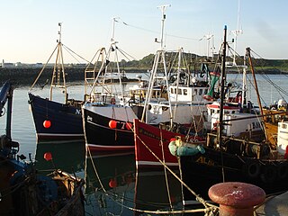
Ardglass is a coastal fishing village, townland and civil parish in County Down, Northern Ireland, in the historic barony of Lecale Lower. It is still a relatively important fishing harbour. It is situated on the B1 Ardglass to Downpatrick road, about 6 miles to the south east of Downpatrick, in the Lecale peninsula on the Irish Sea. It had a population of 1,668 in the 2001 Census, and is located within the Newry, Mourne and Down area.

The Gallarus Oratory (Irish: Séipéilín Ghallarais, Gallarus being interpreted as either 'rocky headland' or 'house or shelter for foreigner ' is a chapel on the Dingle Peninsula, County Kerry, Ireland. It has been presented variously as an early-Christian stone church by antiquary Charles Smith, in 1756; a 12th century Romanesque church by archaeologist Peter Harbison in 1970; a shelter for pilgrims by the same in 1994. The local tradition prevalent at the time of Charles Smith attributed it to one Griffith More, being a funerary chapel built by him or his family at their burial place.

Oranmore is a town near the city of Galway in County Galway, Ireland. It is also the name of the civil parish and Roman Catholic parish in which the town lies.
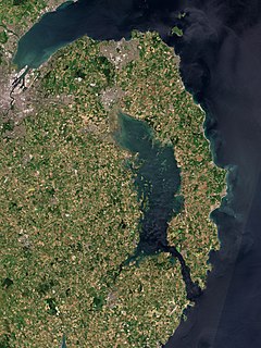
The Ards Peninsula is a peninsula in County Down, Northern Ireland, on the north-east coast of Ireland. It separates Strangford Lough from the North Channel of the Irish Sea. Towns and villages on the peninsula include Donaghadee, Millisle, Portavogie and Portaferry. The large towns of Newtownards and Bangor are at the mainland edge of the peninsula. Burr Point is the easternmost point on the island of Ireland.
Greyabbey or Grey Abbey is a small village, townland and civil parish located on the eastern shores of Strangford Lough, on the Ards Peninsula in County Down, Northern Ireland.

Caherconnell is an exceptionally well-preserved medieval stone ringfort in region known as the Burren, County Clare, Ireland. It lies about 1 km south of the Poulnabrone dolmen.

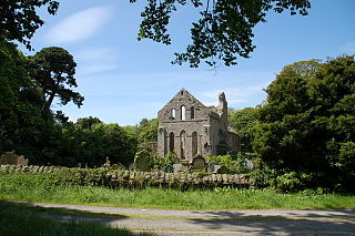
Movilla Abbey in Newtownards, County Down, Northern Ireland, is believed to have been one of Ulster's and Ireland's most important monasteries. Movilla should not be confused with Moville in County Donegal.

The oratory Teampall Bheanáin is situated near Kilronan on Inishmore, Aran, Galway Bay, Ireland. A unique example of Celtic church construction. It marks the location of the original monastic settlement founded by Benen, a disciple of St. Patrick, the national saint of Ireland. It dates from the 11th century, and has stood unaltered a thousand years.

Milecastle 10 was a milecastle of the Roman Hadrian's Wall. It is located near to the modern village of Throckley in Tyne and Wear, northern England. Much of the milecastle lies beneath a road but partial remains of the north wall can be seen in the garden of Dene House. It has been excavated several times and its walls located, though the remains have been "considerably damaged by ploughing". Only one of the two associated turrets has been located and excavated.

St Mary's Church is a redundant medieval Anglican church in the village of Barton Bendish, Norfolk, England. This village had two more parish churches –St Andrew’s Church, and All Saints’ Church (demolished). St Mary’s is recorded in the National Heritage List for England as a designated Grade I listed building, and is under the care of the Churches Conservation Trust. The architectural historian Nikolaus Pevsner was of the opinion that its west door is "one of the best Norman doorways in England". The church stands in an isolated position to the west of the village.

All Saints Church is a partly redundant Anglican church in the village of Newton Green, Suffolk, England. It is recorded in the National Heritage List for England as a designated Grade II* listed building. The chancel is still in use for worship, but the nave, porch and tower are redundant and vested in the care of the Churches Conservation Trust. The church stands towards the north of the village, some two miles east of Sudbury.

Dripsey Castle is a country house in the townland of Carrignamuck, situated 3.3 km (2.1 mi) north-east of Coachford village and 2.5 km (1.6 mi) north-west of Dripsey village. The house and demesne were dominant features in the rural landscape of Ireland, throughout the eighteenth and nineteenth centuries. Location often reflected the distribution of better land, and this is evidenced in mid-Cork, where many of these houses are situated along the valley of the River Lee and its tributaries.

Kilcorney is a civil parish in County Clare, Ireland. It lies in the Burren region of the northwest of the county.
St Tanwg's Church, Llandanwg, also known as "the church in the sand", is an early medieval church dedicated to St Tanwg in the village of Llandanwg, Gwynedd, Wales. The church is a Grade I listed building.
Lickbla, is a historic monument, civil parish, religious parish, and townland, in County Westmeath, Ireland. It is located about 23.05 kilometres (14 mi) north of Mullingar. St. Bladma is listed in the Martyrology of Oengus as a saint: "Bladma, i.e. from Blad son of Conmac Cas Clothach, grandson of Tachall son of Cermait, son of the Dagda, a quo nominatur. Or Blad son of Breogan, a quo Sliab Bladma" whose feastday is 7 April and 20 November.
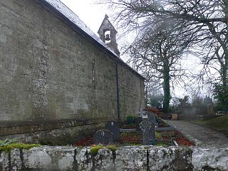
St. Cronan's Church is a 10th-century Church of Ireland church in Tuamgraney, County Clare, Ireland. It is the oldest church in continuous use in Ireland. The Tuamgraney parish operates as a unit with the Mountshannon parish in the Killaloe Union of parishes in the Diocese of Limerick and Killaloe.

Furnaceland is a townland in the civil parish of Kinawley, barony of Tullyhaw, County Cavan, Ireland. The original Irish place name was Maghernavinagh, which in Gaelic was either Machaire Eanach, meaning "The Plain of the Marsh" or Machaire Mhianach, meaning "The Plain of the Mine"). The town of Swanlinbar is partially situated in Furnaceland.

Hawkswood is a townland in the civil parish of Kinawley, barony of Tullyhaw, County Cavan, Ireland. The original Irish place name was Cluain Caomh meaning 'The Beautiful Meadow'. The town of Swanlinbar is partially situated in Hawkswood. According to the 1938 Dúchas collection two sub-divisions are- The Cleity - A name given to a field in a farm owned by Mr. Patrick Maguire, Hawkswood, Swanlinbar, Co. Cavan. The Rhythars - a name given to a field in a farm owned by Mr Hugh McBrien, Hawkswood, Swanlinbar.

Saint John's Point or St. John's Point is a cape at the southern tip of the Lecale peninsula of County Down Northern Ireland, separating Dundrum Bay from Killough Harbour, which forms its northern extremity. The cape is mostly surrounded by the Irish Sea and derives its name from a now ruined church dedicated to Saint John, being recorded here since at least 1170. A well known beacon in the north-eastern Irish Sea, St. John's Point Lighthouse, built in 1844, sits near its southern tip and, at 40 m (130 ft), is the tallest lighthouse in Ireland.
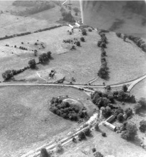
Old Moybologue Cemetery is a circular enclosure in County Cavan, Ireland. The site dates from the Early Christian Period and features the ruins of a mediaeval church and a graveyard.
