Aughey is a townland of 109 acres in County Fermanagh, Northern Ireland. It is situated in the civil parish of Derryvullan and the historic barony of Tirkennedy.

Laragh is a townland of 132 acres in County Fermanagh, Northern Ireland. It is situated in the civil parish of Trory and the historic barony of Tirkennedy. It is near Enniskillen Airport.
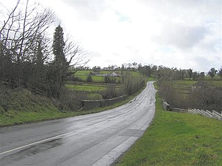
Trory is a townland, small village and civil parish in County Fermanagh, Northern Ireland, 3 miles (5 km) north of Enniskillen. The townland is situated in the historic barony of Tirkennedy, but the civil parish covers areas of the barony of Tirkennedy, as well as the barony of Lurg. In the 2001 Census it had a population of 315 people. It lies within the Fermanagh and Omagh District Council area.
Tamlaght is a townland and village in County Fermanagh, Northern Ireland, 4.5 km south-east of Enniskillen. It is situated in the civil parish of Derryvullan and the historic barony of Tirkennedy. In the 2001 Census it had a population of 276 people.
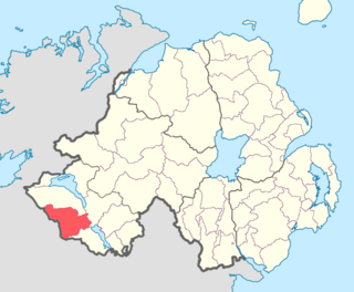
Clanawley is a barony in County Fermanagh, Northern Ireland. To its east lies Upper Lough Erne, and it is bordered by three other baronies: Magheraboy to the north; Tirkennedy and Knockninny to the east. It also borders three baronies in the Republic of Ireland: Tullyhaw to the south; and Drumahaire and Rosclogher to the west.
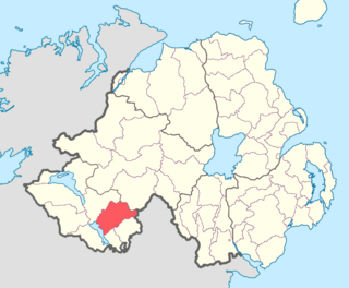
Magherastephana is a barony in County Fermanagh, Northern Ireland. To its south-west lies Upper Lough Erne, and it is bordered by five other baronies: Tirkennedy to the west; Knockninny to the south-west; and Coole to the south; Clankelly to the south-east; and Clogher to the north-west.

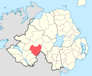
Tirkennedy is a barony in County Fermanagh, Northern Ireland. To its west lies Lower Lough Erne and south Upper Lough Erne, and it is bordered by seven other baronies: Clanawley and Magheraboy to the west; Lurg and Omagh East to the north; Clogher to the east; Magherastephana and Knockninny to the south.

Magheraboy is a barony in County Fermanagh, Northern Ireland. To its east lies Lower Lough Erne, and it is bordered by three other baronies in Northern Ireland: Lurg to the north; Tirkennedy to the east; and Clanawley to the south It also borders two baronies in the Republic of Ireland: Tirhugh to the north; and Rosclogher to the south. The westernmost point of Magheraboy is also the westernmost point of Northern Ireland and even the westernmost piece of land of the United Kingdom..

Lurg is a barony situated in the north of County Fermanagh, Northern Ireland. To its south lies Lower Lough Erne, and it is bordered by four other baronies in Northern Ireland: Magheraboy to the south; Tirkennedy to the south-east; Omagh West to the north; and Omagh East to the east. It also borders to the west the barony of Tirhugh in the Republic of Ireland.
Clogher is a barony in County Tyrone, Northern Ireland. It is bordered by four other baronies in Northern Ireland: Omagh East to the north; Dungannon Lower to the east; Magherastephana to the south; and Tirkennedy to the south-west. It also borders two baronies in the Republic of Ireland: Trough and Monaghan both to the south-east.

Magheracross is a townland and civil parish in County Fermanagh, Northern Ireland. It extends in area from just north of Enniskillen to the Border with County Tyrone. There is also a small enclave in County Tyrone.
Derryvullan is a civil parish and townland in County Fermanagh, Northern Ireland. The civil parish is situated in the historic baronies of Tirkennedy and Lurg. Derryvullan townland is in the portion of the parish of the same name in Tirkennedy.
Aghavea is a civil parish and townland in County Fermanagh, Northern Ireland. It is situated in the historic barony of Magherastephana.
Drumcreen, Northern Ireland is a locality and townland in Northern Ireland, located at 54° 25' 28" N, 7° 34' 38" W.

Salry is a townland and locality in Mageracross civil parish, County Fermanagh, Northern Ireland. It is located at 54° 24' 53" N, 7° 36' 47" W. Salry is in the Barony of Tirkennedy and is 212.98 acres in area.

Salloon, Northern Ireland is a locality and townland in Mageracross civil parish, County Fermanagh, Northern Ireland.

Sidaire is a townland in Mageracross civil parish, County Fermanagh, Northern Ireland. It is located in the Barony of Tirkennedy civil Parish of Mageracross It is 327.37 acres in area, and is bounded by the Ballinamallard River to the south the town of Ballinamallard to the east and the Enniskillen Road to the west. The topography is generally pastures on undulating hillsides.
Arney is a civil parish located in the barony of Clanawley and Tirkennedy in County Fermanagh, Northern Ireland. It is located in the Roman Catholic Diocese of Clogher.