Related Research Articles

The Derwent is a famous river in the county of Cumbria in the north of England; it rises in the Lake District and flows northwards through two of its principal lakes, before turning sharply westward to enter the Irish Sea at Workington
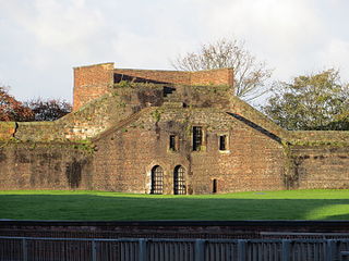
Cockermouth is a market town and civil parish in the Cumberland unitary area of Cumbria, England, so named because it is at the confluence of the River Cocker as it flows into the River Derwent. The mid-2010 census estimates state that Cockermouth has a population of 8,204, increasing to 8,761 at the 2011 Census.
The Carvetii were a Brittonic Celtic tribe living in what is now Cumbria, in North-West England during the Iron Age, and were subsequently identified as a civitas (canton) of Roman Britain.

Maryport is a town and civil parish in Cumbria, England.

Birdoswald Roman Fort was known as Banna in Roman times, reflecting the geography of the site on a triangular spur of land bounded by cliffs to the south and east commanding a broad meander of the River Irthing in Cumbria below.

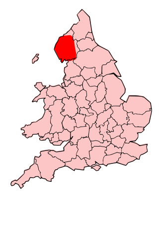
The history of Cumbria as a county of England begins with the Local Government Act 1972. Its territory and constituent parts however have a long history under various other administrative and historic units of governance. Cumbria is an upland, coastal and rural area, with a history of invasions, migration and settlement, as well as battles and skirmishes between the English and the Scots.

Ambleside Roman Fort is the modern name given to the remains of a fort of the Roman province of Britannia. The ruins have been tentatively identified as Galava, mentioned in the Antonine Itinerary. Dating to the 1st or 2nd century AD, its ruins are located on the northern shore of Windermere at Waterhead, near Ambleside, in the English county of Cumbria, within the boundaries of the Lake District National Park.

Alauna was a castrum or fort in the Roman province of Britannia. It occupied a coastal site just north of the town of Maryport in the English county of Cumbria.
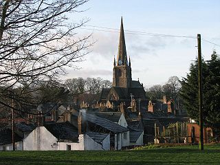
Papcastle is a village and civil parish in the borough of Allerdale in the English county of Cumbria. The village is now effectively a northern extension of Cockermouth, which lies to the south of the River Derwent. It has its own parish council and lies within Bridekirk Parish for Church of England purposes. In 2001 it had a population of 406, reducing to 385 at the 2011 Census.

Mealsgate is a village in Cumbria, England, historically within Cumberland.

Uxelodunum was a Roman fort with associated civilian settlement (vicus) in modern-day Carlisle, Cumbria, England. It was the largest fort on Hadrian's Wall and is now buried beneath the suburb of Stanwix.

Aballava or Aballaba was a Roman fort on Hadrian's Wall, between Petriana (Stanwix) to the east and Coggabata (Drumburgh) to the west. It is about one and a half miles south of the Solway Firth, and its purpose was to guard the south end of two important Solway fords, the Peat Wath and the Sandwath, which were also to become favourite routes for medieval border raiders.
Portinscale is a village in Cumbria, England, close to the western shore of Derwentwater in the Lake District National Park 1+1⁄2 miles from Keswick.

Brocavum is the Latin name of a Roman fort at Brougham near Penrith, Cumbria. The fort survives as earthworks, but no excavation of these has been carried out so far.

Derventio, sometimes described as Derventio Brigantium in order to distinguish it from other places called Derventio, was a Roman fort and settlement located beneath the modern town of Malton in North Yorkshire, England. The fort is positioned 18 miles north-east of Eboracum on the River Derwent.
Carlisle city walls were a defensive structure surrounding the centre of Carlisle, Cumbria. The city walls ran from Carlisle Castle in the north-west of the city to The Citadel in the south-east. Between these points, the city was protected by the former North and East Walls and the West Walls which remain largely intact. The line of the walls can still be followed with the exception of the southernmost end of the West Wall which has been built over. The perimeter, including the castle, is approximately 2.2 kilometres (1.4 mi) which is comparable to Southampton town walls but less than Chester city walls.
The Cumberland and Westmorland Antiquarian and Archaeological Society, founded in 1866, is a local historical, antiquarian, archaeological and text publication society and registered charity covering the modern county of Cumbria.
Roman Cumbria was an area that lay on the north-west frontier of Roman Britain, and, indeed, of the Roman Empire itself.. Interest in the Roman occupation of the region lies in this frontier aspect: why did the Romans choose to occupy the north-west of England; why build a solid barrier in the north of the region ; why was the region so heavily militarised; to what extent were the native inhabitants "Romanised" compared to their compatriots in southern England?
Over Burrow Roman Fort is the modern name given to a former Roman fort at Over Burrow, Lancashire in North West England. Today it is the site of the 18th-century country house Burrow Hall. The first castra is thought to have been founded in the first century AD within the Roman province of Britannia.
Katherine "Kate" Sophia Hodgson FSA (1889–1974) was an amateur archaeologist whose primary research concerned the archaeology of Cumbria, North-West England. She was elected as a Fellow of the Society of Antiquaries in 1949, and served as president of the Cumberland and Westmorland Antiquarian and Archaeological Society between 1948 and 1951.
References
- ↑ The name is known from the Ravenna Cosmography. See Esmonde Cleary, A., DARMC, R. Talbert, S. Gillies, S. Vanderbilt, R. Warner, J. Becker, T. Elliott. "Places: 89165 (Derventio)". Pleiades (pleiades.stoa.org). Retrieved 2 January 2016.
{{cite web}}: CS1 maint: multiple names: authors list (link) - ↑ "Cockermouth Castle". Heritage Open Days. September 2015. Archived from the original on 18 February 2016. Retrieved 6 January 2016.
- ↑ Birley, Eric (1963). "Roman Papcastle" (PDF). Transactions of the Cumberland and Westmorland Antiquarian and Archaeological Society. 63 (Second Series): 96–125. - reviews all antiquarian descriptions and Collingwood's investigation of 1912
- ↑ Collingwood, R G (1913). "Report of Excavations at Papcastle, 1912" (PDF). Transactions of the Cumberland and Westmorland Antiquarian and Archaeological Society. 13 (Second Series): 131–141.
- ↑ Charlesworth, Dorothy (1965). "Excavations at Papcastle, 1961-2" (PDF). Transactions of the Cumberland and Westmorland Antiquarian and Archaeological Society. 65 (Second Series): 102–114.
- ↑ Historic England. "Roman forts at Papcastle and part of the vicus (1007760)". National Heritage List for England . Retrieved 2 December 2017.
- ↑ Historic England. "Derventio Roman Fort (9491)". Research records (formerly PastScape). Retrieved 3 December 2017.
- ↑ TV.com. "Time Team: Papcastle, Cumbria". TV.com.
- 1 2 "Digs". Discovering Derventio. Grampus Heritage. Retrieved 3 December 2017. has draft reports for pre-2014 excavations - an overall report on the project in the Transactions of the Cumberland and Westmorland Antiquarian and Archaeological Society was envisaged, but (as of December 2017) has yet to appear