Deschênes, Quebec

Last updated • 5 min readFrom Wikipedia, The Free Encyclopedia

Deschênes is a former municipality in Quebec, Canada, located in the Outaouais region. Along with Lucerne, it was a part of the municipality of Aylmer in 1975, itself amalgamated into the City of Gatineau in 2002. Originally, the name of the village was Deschênes Mills.

History

Traces of human presence dating from 6-8000 years before today have been found in the Ottawa Valley (Outaouais region). Around 500 BC the population known as the Algonquin (Anishinàbeg) people is established, whose territory will span the length of the Kichi Zibi River (the Great or Grand River), known today as the Ottawa River.. [1]

In 1610, Samuel de Champlain sent Nicolas de Vignau on a mission to learn the Algonquin language. Vignau travelled up the river and spent a year with the Indigenous inhabitants. He became the second European to pass by the Deschênes rapids - Étienne Brûlé was the first. In his passage that led him towards the Mattawa River and the French River to finally reach Lake Huron and the land of the First Nation called the Odawa (Odàwà). As a result of the trade established with this First Nation, which continued throughout the 17th century, the name Ottawa (written variably as 8ta8ois, Utawàs, and more recently, Outaouais) became attached to the river by the French, even though these Indigenous people never lived in the Valley. [2]

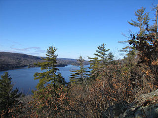
It is Pierre de Troyes, a commander of Pierre Le Moyne d'Iberville's expedition, who would first write the French name Deschênes. [3] The French name was a translation of the Algonquin name Mitigomijokan (meaning the place of the oak), it is what de Troyes was told on his journey on April 23, 1686. [4] This site was the third portage or "upper portage of the Chaudière" which leads upstream to the widening of the river, then called lac Chaudière or Chaudière Lake (today called lac Deschênes ). Having passed through the rapids, de Troyes must have seen the impressive forest of oaks and writes that the area of the portage is called des chesnes (oak is chêne, in French).

In 1800, the first permanent settlers in the Ottawa Valley arrived with Philemon Wright and his family and begin to build Wright's Town, Lower Canada at the Chaudière Falls. Two years later, upriver and in what would become the Deschênes area, 35-year-old James McConnell from Prince Edward Island settled along with his two brothers, William (17) and George (10) [5] The McConnells were part of the second wave of permanent settlers in the farming community of Philemon Wright. According to the surveys of Theodore Davis and the register of Philemon Wright, James McConnell would occupy lot 14-a of the first range. A while later, his brother William cleared a farm on the neighbouring lot 13 of the first range.

In 1810, James McConnell leased lot 15 of the first range, [6] cleared the land for agriculture and excavated a mill run to what was to be the first mill, thus marking the very beginning of the village of Deschênes Mills. [7]

Eleven years later, a store is in operation near the rapids. The McConnell brothers would make their fortunes in the timber industry, as farmers, and in the petty fur trade - taking over the petty fur trade business established by failed trader Ithamar Day [8] in 1826.

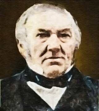
Merchant Robert Conroy (politician) and his wife Mary, daughter of William McConnell, settled in Aylmer in 1837 and built the British Hotel. They invested heavily in this region in the development of transportation services, timber slides, landings, the macadamized Aylmer road, bridges and stagecoach services. [9]

Ile Conroy 21 mars 2021 Ile Conroy 21 mars 2021.jpg
Île Conroy 21 mars 2021
Ruines de Deschenes 2020 Ruines de Deschenes 2020.jpg
Ruines de Deschênes 2020

In 1857, Mary Conroy bought a farm near the Deschênes rapids and transformed it into one of the most prosperous dairy farms in the Outaouais. Her husband died in 1868 and she took over the management of the family businesses, a rarity at that time for a woman. She modernized their sawmill and built a second one which produced nearly 30 million board feet in one season. Two hundred sawmill workers settled in the village of Deschênes Mills building up in Lots 15 and 16 along the Ottawa River near the rapids. [10]

Ruines Deschenes vues des airs Ruines Deschenes vues des airs.jpg
Ruines Deschênes vues des airs

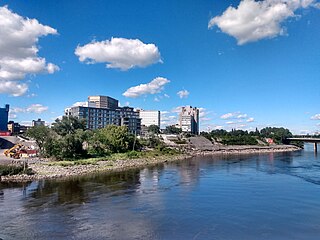
On the death of their mother, the management of the family businesses was placed in the hands of her ten children. Two of the boys, Robert and William Conroy, built one of the two hydroelectric power stations at the Deschênes rapids, the Deschênes Electric Company (1896-1946). The second one was built by the Hull Electric Company [11] A large stone building, built by this second company for use as a shed and repair garage for streetcars, still exists at the corner of Vanier Road and Lucerne Boulevard. [12] These two plants supplied the surrounding neighbourhoods, the factories, and the tramway linking Hull & Ottawa to Aylmer. The ruins of these dams are still present.

A British American Nickel Corporation nickel refinery (1916 – 1923) was built during the Great War and quickly became the most efficient refinery in Canada. For some unknown reason, Prime Minister William Lyon Mackenzie King ordered it closed in 1923. Its ruins stood until 1985.

The village of Deschênes was incorporated in 1920 and the Catholic parish of Saint-Médard was promulgated in 1923. Following the departure of industries, the village is transformed into a resort for people from Hull and Ottawa but gradually the chalets would be winterized or replaced by habitable year-round homes. In the wake of the policy of regrouping the municipalities of Quebec, the villages of Aylmer, Lucerne and Deschênes were merged on January 1, 1975, to become the municipality of Aylmer. On 1 January 2002, it is itself attached to the municipality of Gatineau where Deschênes became a district with its own municipal councillor.

Related Research Articles

<span class="mw-page-title-main">Gatineau</span> City in Quebec, Canada

Gatineau is a city in southwestern Quebec, Canada. It is located on the northern bank of the Ottawa River, immediately across from Ottawa, Ontario. Gatineau is the largest city in the Outaouais administrative region of Quebec and is also part of Canada's National Capital Region. As of 2021, Gatineau is the fourth-largest city in Quebec with a population of 291,041, and it is part of the Ottawa-Gatineau census metropolitan area with a population of 1,488,307 making it the fourth largest in Canada.

<span class="mw-page-title-main">Hull, Quebec</span> Sector in Gatineau, Quebec, Canada

Hull is the central business district and oldest neighbourhood of the city of Gatineau, Quebec, Canada. It is located on the west bank of the Gatineau River and the north shore of the Ottawa River, directly opposite Ottawa. As part of Canada's National Capital Region, it contains offices for more than 20,000 civil servants. It was named after Kingston upon Hull in England.

<span class="mw-page-title-main">Buckingham, Quebec</span> Sector within City of Gatineau in Quebec, Canada

Buckingham is a former town located in the Outaouais region in the western portion of the province of Quebec, Canada. Since January 1, 2002, it has been part of the amalgamated city of Gatineau, which merged five former municipalities, including Masson-Angers, Buckingham, Hull, Aylmer and Gatineau, into a single entity. According to the 2021 Census, the population of the sector was 12,795.

<span class="mw-page-title-main">Philemon Wright</span> Canadian politician

Philemon Wright was a farmer, lumberman and entrepreneur who founded the Ottawa River timber trade in 1806. He was also founder of what he named Columbia Falls Village, mostly known as Wright's Town, Lower Canada and Wright's Village to others, the first permanent settlement in the National Capital Region of Canada. Wright's Town, later became incorporated in 1875 and renamed Hull, Quebec, and then in 2002, as a result of a municipal amalgamation, it acquired its present name of the City of Gatineau.

<span class="mw-page-title-main">Aylmer, Quebec</span> Sector within City of Gatineau in Quebec, Canada

Aylmer is a former city in Quebec, Canada. It is located on the north shore of the Ottawa River and along Route 148. In January 2002, it amalgamated into the city of Gatineau, which is part of Canada's National Capital Region. Aylmer's population in 2011 was 55,113. It is named after Lord Aylmer, who was a governor general of British North America and a lieutenant governor of Lower Canada from 1830 to 1835.

<span class="mw-page-title-main">Outaouais</span> Administrative region in Quebec, Canada

Outaouais is a region of western Quebec, Canada. It includes the city of Gatineau, the municipality of Val-des-Monts, the municipality of Cantley and the Papineau region. Geographically, it is located on the north side of the Ottawa River opposite Canada's capital, Ottawa. It has a land area of 30,457.52 square kilometres (11,759.71 sq mi) and its population was 405,158 inhabitants as of 2021.

<span class="mw-page-title-main">National Capital Region (Canada)</span> Metropolitan area in Canada

The National Capital Region (NCR), also known as Canada's Capital Region and Ottawa–Gatineau, is an official federal designation encompassing the Canadian capital of Ottawa, Ontario, the adjacent city of Gatineau, Quebec, and surrounding suburban and exurban areas. Despite its designation, the NCR is not a separate political or administrative entity and falls within the provinces of Ontario and Quebec.

<span class="mw-page-title-main">Gatineau River</span> River in western Quebec, Canada

The Gatineau River is a river in western Quebec, Canada, which rises in lakes north of the Baskatong Reservoir and flows south to join the Ottawa River at the city of Gatineau, Quebec. The river is 386 kilometres (240 mi) long and drains an area of 23,700 square kilometres (9,200 sq mi).

<span class="mw-page-title-main">Chaudière Falls</span> Waterfalls on the Ottawa River, Canada

The Chaudière Falls, also known as the Kana:tso or Akikodjiwan Falls, are a set of cascades and waterfall in the centre of the Ottawa-Gatineau metropolitan area in Canada where the Ottawa River narrows between a rocky escarpment on both sides of the river. The location is just west of the Chaudière Bridge and Booth-Eddy streets corridor, northwest of the Canadian War Museum at LeBreton Flats and adjacent to the historic industrial E. B. Eddy complex. The islands surrounding the Chaudière Falls, counter-clockwise, are Chaudière Island, Albert Island, little Coffin Island was just south of Albert Island but is now submerged, Victoria Island and Amelia Island,, Philemon Island was originally called the Peninsular Village by the Wrights but became an island when the timber slide was built in 1829 it is now fused to south shore of City of Gatineau, and Russell Island, now submerged, was at the head of the Falls before the Ring dam was built. The falls are about 60 metres (200 ft) wide and drop 15 metres (49 ft). The area around the falls was once heavily industrialized, especially in the 19th century, driving growth of the surrounding cities.

<span class="mw-page-title-main">Boulevard des Allumettières</span>


Boulevard des Allumettières is a major 13.7 km arterial road in Gatineau, Quebec, Canada, that connects Aylmer and Hull sectors of the city running from Eardley Road to the Alexandra Bridge towards Ottawa. It is the most recent east-west arterial connection from the West to the downtown core and construction of the entire length was completed during the fall of 2007.

<span class="mw-page-title-main">Portage Bridge</span> Bridge

The Portage Bridge crosses the Ottawa River just down-river from the Chaudière Bridge, joining the communities of Gatineau, Quebec and Ottawa, Ontario. It links Laurier Street and Alexandre-Taché Boulevard in the Hull sector of Gatineau and Wellington Street at the Garden of the Provinces and Territories in Ottawa, crossing Victoria Island and the former Philemon Island on the way.

<span class="mw-page-title-main">Robert Labine</span> Canadian politician (1940–2021)

Robert "Bob" Labine was a politician in Gatineau, Quebec. He was best known for being mayor of the former city of Gatineau between 1988 and 1994 and again between 1999 and 2001.

<span class="mw-page-title-main">Geography of Ottawa</span>

This is the outline of the geography of the city of Ottawa, the capital of Canada. Ottawa's current borders were formed in 2001, when the former city of Ottawa amalgamated with the ten other municipalities within the former Regional Municipality of Ottawa–Carleton. Ottawa is now a single-tiered census division, home to 1,017,449 people.

<span class="mw-page-title-main">Lac Deschênes</span> Lake in Canada

Lac Deschênes is a 44 kilometres long lake on the Ottawa River that runs from the Chats Falls Dam near Fitzroy Harbour in the west to the Deschênes Rapids at Britannia in the east. It is a little over 3.2 kilometres wide at its widest point and little more than a few hundred metres at its narrowest. The provincial border between Ontario and Quebec runs through the length of the lake with the City of Ottawa on its southern shore and the city of Gatineau on much of its northern shore.

The history of Ottawa, capital of Canada, was shaped by events such as the construction of the Rideau Canal, the lumber industry, the choice of Ottawa as the location of Canada's capital, as well as American and European influences and interactions. By 1914, Ottawa's population had surpassed 100,000 and today it is the capital of a G7 country whose metropolitan population exceeds one million.

<span class="mw-page-title-main">Ottawa River timber trade</span> Historic timber industry in the Ottawa Valley of Ontario, Canada

The Ottawa River timber trade, also known as the Ottawa Valley timber trade or Ottawa River lumber trade, was the nineteenth century production of wood products by Canada on areas of the Ottawa River and the regions of the Ottawa Valley and western Quebec, destined for British and American markets. It was the major industry of the historical colonies of Upper Canada and Lower Canada and it created an entrepreneur known as a lumber baron. The trade in squared timber and later sawed lumber led to population growth and prosperity to communities in the Ottawa Valley, especially the city of Bytown. The product was chiefly red and white pine.The Ottawa River being conveniently located with access via the St. Lawrence River, was a valuable region due to its great pine forests surpassing any others nearby. The industry lasted until around 1900 as both markets and supplies decreased, it was then reoriented to the production of wood pulp which continued until the late 1990s and early 2000s.

<span class="mw-page-title-main">Charles Symmes</span> Canadian politician

Charles Symmes was an American-born business owner and politician in Quebec. Considered the father of Aylmer, Quebec he was its mayor from 1855 to 1858 and again from 1860 to 1862.

Robert Conroy was an Irish-born business owner and politician in Quebec. He served as mayor of Aylmer from 1858 to 1860 and from 1866 to 1868. He was considered one of the most prosperous hotel operators and lumber barons in the Ottawa Valley during the 1850s.

<span class="mw-page-title-main">Wright's Town, Lower Canada</span> Historical settlement in present-day Gatineau, Quebec, Canada

Wright's Town, also known as Wrightstown, Wright's Village, and Columbia Falls Village, was the first permanent colonial settlement in the Ottawa Valley, located at the north edge of the Chaudière Falls on the Ottawa River, on the southern part of what is now known as Hull Island, in present-day Gatineau, Quebec, Canada. Wright's Town was established by and named after American settler Philemon Wright, who settled in the area in 1800.

<span class="mw-page-title-main">Philemon Island</span>

Philemon Island is a former artificial island in the Hull sector of Gatineau, Quebec, Canada. Currently part of the mainland, it was once an island in the Ottawa River, separated from the mainland by a timber slide for nearly 150 years. It was part of an archipelago of islands below Chaudière Falls, known as the "Chaudière Islands" that contain Victoria Island, Chaudière Island, Amelia Island and Albert Island. It is accessible via Rue Eddy and the Portage Bridge.

References

  1. Michelle Guitard, « Deschênes : Histoire des rapides et son village », October 2019, https://www.gatineau.ca/docs/guichet_municipal/archives/docs/histoire_deschenes.pdf
  2. Michelle Guitard, « Deschênes : Histoire des rapides et son village », October 2019, https://www.gatineau.ca/docs/guichet_municipal/archives/docs/histoire_deschenes.pdf
  3. Brève histoire du secteur Deschênes, Gatineau, https://histoirepatrimoineducation.net/2014/04/23/breve-histoire-du-secteur-deschenes-gatineau/
  4. Michelle Guitard, « Deschênes : Histoire des rapides et son village », October 2019, https://www.gatineau.ca/docs/guichet_municipal/archives/docs/histoire_deschenes.pdf
  5. The Descendants of Robert McConnell, https://www.islandregister.com/mcconnell1.html, 12/15/2013
  6. List of Leases of Reserved Lots in the Township of Hull to PHILEMON WRIGHT by grant, https://www.gvhs.ca/wright/pdf/a_273.pdf
  7. Aylmer: a Tale of Two Landings (1800-1830), https://www.capitalchronicles.ca/post/aylmer-a-tale-of-two-landings-1800-1830
  8. Pioneers of the Upper Ottawa and the humors of the valley, Anson Gard, Ottawa: Emerson Press, 1906, pgs.45-46, https://www.canadiana.ca/view/oocihm.71321/5
  9. Qui est Mary McConnell-Conroy ?, https://histoirepatrimoineducation.net/2020/05/12/qui-est-mary-mcconnell-conroy/, 12 mai 2020
  10. Qui est Mary McConnell-Conroy ?, https://histoirepatrimoineducation.net/2020/05/12/qui-est-mary-mcconnell-conroy/, 12 mai 2020
  11. Deschenes Electric Company, https://histoirepatrimoineducation.net/tag/deschenes-electric-company/
  12. Quand Hull et Aylmer avaient leur tramway, Paul Gaboury, Le Droit, 10 novembre 2019