Della Falls is a waterfall in Strathcona Provincial Park on Vancouver Island and is among one of the tallest waterfalls in Canada.

The Nass River is a river in northern British Columbia, Canada. It flows 380 km (240 mi) from the Coast Mountains southwest to Nass Bay, a sidewater of Portland Inlet, which connects to the North Pacific Ocean via the Dixon Entrance. Nass Bay joins Portland Inlet just south of Observatory Inlet.

The Cheakamus River is a tributary of the Squamish River, beginning on the west slopes of Outlier Peak in Garibaldi Provincial Park upstream from Cheakamus Lake on the southeastern outskirts of the resort area of Whistler. The river flows into Cheakamus Lake before exiting it and flowing northwest until it turns south and enters Daisy Lake. Between the outlet of Daisy Lake and its mouth, much of its length is spent going through Cheakamus Canyon, where the river flows through swift rapids and even one good sized waterfall. The river flows south from the lake and through the canyon before joining the Squamish River at Cheekye, a few miles north of the town of Squamish. The river's name is an anglicization of the name of Chiyakmesh, a village of the Squamish people and a reserve of the Squamish Nation.

The Chilcotin River is a 241-kilometre (150 mi) long tributary of the Fraser River in southern British Columbia, Canada. It drains the Chilcotin Plateau, which lies between the Fraser River and the Coast Mountains. It starts northeast of Itcha Mountain and flows generally southeast to join the Fraser about 22 km upstream from Gang Ranch.

Shannon Falls Provincial Park is a provincial park in British Columbia, Canada. It is located 58 kilometers (36 mi) from Vancouver and 2 kilometers (1.2 mi) south of Squamish along the Sea to Sky Highway. Shannon Falls is the third highest waterfall in British Columbia.

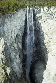
Spahats Creek Falls, also called Spahats Falls, is a waterfall on Spahats Creek within Wells Gray Provincial Park of British Columbia, Canada. Common references place the falls at around 60 m (197 ft) tall, but taking into account the second tier, it is closer to 75–80 meters tall. It is a popular stop for tourists and especially motorcoach tours since it is only 10 km (6.2 mi) off the busy Yellowhead Highway.
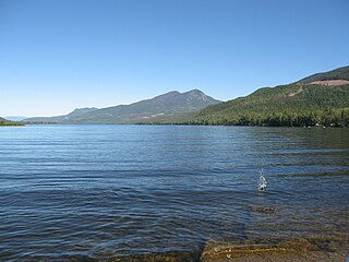
Mahood Lake is a lake in the South Cariboo region of the Interior of British Columbia in Wells Gray Provincial Park. It is drained by the Mahood River, a tributary of the Clearwater River which has cut a deep canyon into Cambrian rocks and Pleistocene glacial moraines. Mahood Lake is fed by the short Canim River, which drains nearby Canim Lake to the west via Canim Falls and Mahood Falls.

Mount Alfred is a mountain located at the Queen Reach arm and head of the Jervis Inlet within the Pacific Ranges of the Coast Mountains in British Columbia, Canada. The mountain is the highest in the portion of the mainland between Jervis and Toba Inlets, with its 1,318 metres (4,324 ft) prominence defined by the pass at the head of the Skwawka River, which feeds the head of Jervis Inlet. The unofficially-named Alfred Creek Falls, on Alfred Creek which drains off the mountain's glaciers southeast into the Skwawka, is one of Canada's highest waterfalls at 700 metres (2,297 ft).

Depot Creek, also known as Brown Creek and Kokanee Creek, is a large creek in south-central British Columbia, Canada and Whatcom County, Washington, United States. It is in the Pacific Ocean drainage basin, and is located in the North Cascades. There is a waterfall along its course, Depot Creek Falls.
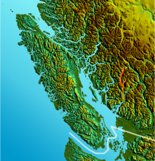
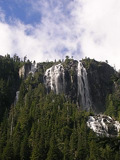
Hotham Sound is a sidewater of Jervis Inlet on the South Coast of British Columbia, Canada, located near the mouth of that inlet on the north flank of its lower reaches, roughly opposite the mouth of Sechelt Inlet. There is a deep basin at its entrance reaching a depth of 730 metres (2,395 ft). Harmony Islands Marine Provincial Park is located on the east side of Hotham Sound. The spectacular Harmony Falls, also called Freil Lake Falls, plunges a total of 444 metres (1,457 ft) into the Sound.
The Clowhom River is a short, 19.8-kilometre (12.3 mi) river in British Columbia. It flows into the head of the Salmon Inlet about 26.2 km west of Squamish.
The Tzoonie River is a remote, short river that enters the head of the Narrows Inlet about 36.6 km north of Sechelt, British Columbia.
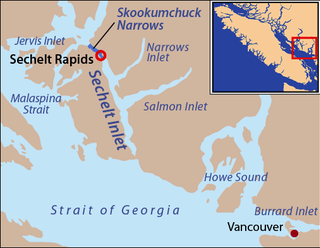
Salmon Inlet is a fjord branching east from Sechelt Inlet in the British Columbia, Canada. Its companion, Narrows Inlet, another side-inlet of Sechelt Inlet, lies roughly 25 miles (40 km) north. Misery and Sechelt Creeks flow freely into the inlet, while the Clowhom River flows in from the artificial Clowhom Lake, formed by a small hydroelectric power development. The fjord is 23 kilometres (14 mi) long; Clowhom Lake, covering a waterfall on the Clowhom River, stretches a further 12 kilometres (7.5 mi) to the western base of Mount Tantalus, which is best known from the direction of Squamish and the Cheakamus Canyon stretch of BC Hwy 99. Heavily affected by logging and milling operations, the inlet is split almost into two portions by an alluvial fan spreading from the mouth of Sechelt Creek.
Alfred Creek, at one time known as Glacier Creek, is a creek flowing off the east flank of Mount Alfred, southeast into the lower reaches of the Skwawka River near its mouth into the head of Jervis Inlet, which is on the South Coast of British Columbia, Canada. It is the location of the unofficially-named Alfred Creek Falls, which cascades 700 meters (2,300 ft) down a sheer rock wall onto an alluvial fan and is one of North America's highest waterfalls.
The Skwawka River is a medium-sized river in the Pacific Ranges of the Coast Mountains in British Columbia, Canada, flowing southeast 20 kilometers (12 mi) into the head of Queens Reach, which is the uppermost end of Jervis Inlet. The pass at the head of the river, which connects to the head of the Little Toba River, is the prominence col for Mount Alfred, which lies just west of the river's mouth and is the highest summit between Jervis and Toba Inlets. Above the river's lower reaches, on the east flank of Mount Alfred, is 700 meters (2,300 ft) Alfred Creek Falls, one of North America's highest.
Hunlen Falls is a waterfall in the Pacific Ranges of the Coast Mountains of British Columbia, Canada. It is located in Tweedsmuir South Provincial Park, west of the communities of Tatla Lake, Kleena Kleene and Nimpo Lake, and east of Bella Coola. It one of the tallest waterfalls in Canada when measured as a continuous unbroken drop. Sources vary, but the official BC Parks measurement is 260 m (853 ft). Other waterfalls such as Della Falls on Vancouver Island are higher, but are of the cascading type. Hunlen Falls drops from the north end of Turner Lake via Hunlen Creek into the Atnarko River, a tributary of the Bella Coola River. Erosion of the canyon below Hunlen Falls has created an alluvial fan into the Atnarko Valley.

Wells Gray Provincial Park is a large wilderness park located in east-central British Columbia, Canada. The park protects most of the southern, and highest, regions of the Cariboo Mountains and covers 5,250 square kilometres. It is British Columbia's fourth largest park, after Tatshenshini, Spatsizi and Tweedsmuir.
The Brittain River is a river of the Sunshine Coast of the Canadian province of British Columbia. It originates in the Pacific Ranges of the Coast Mountains, and flows about 23 km (14 mi) southeast to the Pacific Ocean at the Princess Royal Reach of Jervis Inlet.