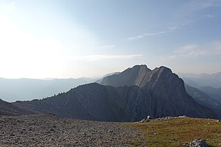
Mount Brazeau is a mountain in Alberta, Canada.

The Peace River is a 1,923-kilometre-long (1,195 mi) river in Canada that originates in the Rocky Mountains of northern British Columbia and flows to the northeast through northern Alberta. The Peace River joins the Athabasca River in the Peace-Athabasca Delta to form the Slave River, a tributary of the Mackenzie River. The Finlay River, the main headwater of the Peace River, is regarded as the ultimate source of the Mackenzie River. The combined Finlay–Peace–Slave–Mackenzie river system is the 13th longest river system in the world.

The Blue Range is a mountain range of the Canadian Rockies, located on the Continental Divide in Banff National Park, Canada. The range was so named on account of its blueish colour when viewed from afar. Mount Alcantara is the highest point in the range.

Division No. 16 is a census division in Alberta, Canada. It is located in the northeast portion of northern Alberta and surrounds the Urban Service Area of Fort McMurray.
The Fiddle Range is a mountain range of the Canadian Rockies located south of Highway 16 on the east border of Jasper National Park, Canada.

Devils Paw is the high point of the Juneau Icefield, on the Alaska–British Columbia border. It is a part of the Boundary Ranges of the Coast Mountains. It is notable for its steep rise above the low local terrain. Its height is sometimes given as 8,507 feet .

Blackie is a hamlet in Alberta, Canada within the Foothills County. It is located approximately 70 kilometres (43 mi) southeast of Calgary on Highway 799.
The Black Bonspiel of Wullie Maccrimmon is a play by Canadian author W. O. Mitchell. It was written as a radio play in 1951, but later produced for television by the Canadian Broadcasting Corporation in 1965. It has since been widely produced across Canada at Alberta Theatre Projects, the Manitoba Theatre Centre, Regina's Globe Theatre, and the Vancouver Playhouse among others.
Howson Peak is a mountain in west central British Columbia, Canada, located 54 km (34 mi) southwest of Telkwa and southwest of the head of Telkwa River. This prominent mountain is the highest of the Howson Range. Howson Peak was first climbed in 1958 after an accident during a 1957 attempt in which Rex Gibson, then president of the Alpine Club of Canada, was killed. That route, as well as many other lines, remains unclimbed. The mountain is now in Tazdli Wiyez Bin or Burnie-Shea Provincial Park. Access is by air to Burnie Lake or on foot from the Kitnayakwa River road. The Burnie Glacier Chalet is the nearest accommodation.
Thudaka Peak is the highest mountain of the Thudaka Range of the Cassiar Mountains in the Northern Interior of British Columbia, Canada, located between the heads of Obo River and Frog River. Glaciers exist on Thudaka's northern flanks, but the zone is usually quite dry.
Shedin Peak is the highest mountain in the Atna Range and in the Skeena Mountains of northern British Columbia, Canada, located 77 km (48 mi) north of Hazelton at the head of Rosenthal Creek. It has a prominence of 1,798 m (5,899 ft), created by the Bear-Driftwood Pass.
Mount Thomlinson is a mountain in the Babine Range of the Skeena Mountains in northern British Columbia, Canada, located at the head of Thomlinson Creek, southeast of the junction of Babine River and Skeena River and north of Hazelton. It has a prominence of 1,661 m (5,449 ft), created by the Babine-Stuart Pass, thus making it one of Canada's many Ultra peaks. Thomlinson is one of the most isolated mountains of Canada.
Mount Cronin is a mountain in the Babine Range of the Skeena Mountains in northern British Columbia, Canada, located at the head of Cronin Creek in Babine Mountains Provincial Park just northeast of Smithers. It has a prominence of 1,571 m (5,154 ft), created by the Harold Price-Fulton Pass, making it one of Canada's Ultra peaks. The mountain was named after James Cronin, who operated a mine on this mountain in the 19th century.

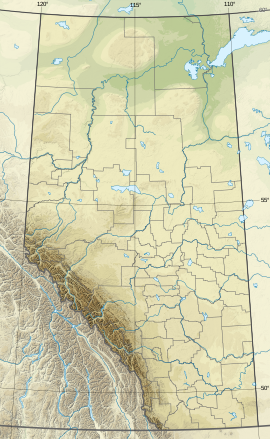
The Rocky Mountain Foothills are an upland area flanking the eastern side of the Rocky Mountains, extending from the Liard River in British Columbia southward into Alberta. Bordering the Interior Plains system, they are part of the Rocky Mountain System or Eastern System of the Western Cordillera of North America.
Bindloss is a hamlet in southern Alberta, Canada within Special Area No. 2. It is located approximately 10 kilometres (6.2 mi) west of Highway 41 and 97 kilometres (60 mi) north of Medicine Hat.
Cessford is a hamlet in southern Alberta, Canada within Special Area No. 2. It is located approximately 22 kilometres (14 mi) east of Highway 36 and 54 kilometres (34 mi) northeast of Brooks.
Dorothy is a hamlet in southern Alberta, Canada within Special Area No. 2. It is located approximately 21 kilometres (13 mi) east of Highway 56 and 85 kilometres (53 mi) northwest of Brooks.
Iddesleigh is a hamlet in southern Alberta, Canada within Special Area No. 2. It is located approximately 37 kilometres (23 mi) northeast of Highway 1 and 46 kilometres (29 mi) northeast of Brooks.

Devil's Gate 220 is a First Nation reserve of the Mikisew Cree First Nation in Alberta, located within the Regional Municipality of Wood Buffalo. It is 10 kilometers north of Fort Chipewyan.