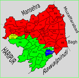
Dhamtore is situated about 6 km east of Abbottabad, Hazara, Khyber Pakhtunkhwa, Pakistan, and is the largest village and union council of Abbottabad. Their language is Hindko which is the traditional mother tongue of the Hazara Division but in some villages especially Nagakki village, Gojri is also the mother tongue. Dhamtour village is the gateway to places like Murree, Nathiagali, Dunga Gali, Bara Gali, Ayubia National Park, Miranjani, Mukeshpuri and the most famous picnic spot of Abbottabad, Harnoi. The Union council is located in Abbottabad District in the Khyber-Pakhtunkhwa province of Pakistan.

Seer Gharbi,سير غربي, is one of the 51 union councils of Abbottabad District in Khyber-Pakhtunkhwa province of Pakistan. It is located in the southeastern part of the province, bordering the Rawalpindi District of Punjab province.

Palak is one of the 51 union councils of Abbottabad District in the Khyber Pakhtunkhwa Province of Pakistan.

Bagnotar is a union council of Abbottabad District in Khyber-Pakhtunkhwa province of Pakistan. Bagnator is situated on the Abbottabad-Nathi Gali Road some 18 kilometers away from Abbottabad.

Birote Kalan is one of the 51 union councils of Abbottabad District in the Khyber-Pakhtunkhwa province of Pakistan.

Namal is one of the 51 union councils of Abbottabad district in the Khyber Pakhtunkhwa province of Pakistan.
Phalla Union council takes its name from the chief village in the area. It is one of the most densely populated union councils of Abbottabad District in Khyber-Pakhtunkhwa province of Pakistan. Most of the area is hilly. These mountain are linked with the mountains of the Murree and Margalla hills of Islamabad. Village Phalla and Ghambir are thickly populated area of this Union Council.

Goreeni is one of the 51 union councils of Abbottabad District in Khyber-Pakhtunkhwa province of Pakistan.

Garhi Phulgran is one of the 51 union councils of Abbottabad District in Khyber-Pakhtunkhwa province of Pakistan.

Pattan Kalan is a residential town and one of the 51 union councils of the Abbottabad District, in the Khyber-Pakhtunkhwa province of Pakistan. It lies within an area that was affected by the 2005 earthquake, after which a total of 27 small camps were set up in the area.

Tajwal is one of the 51 union councils of Abbottabad District in Khyber-Pakhtunkhwa province of Pakistan.

Sarbhana is one of the 51 union councils of Abbottabad District in Khyber-Pakhtunkhwa province of Pakistan.

Pind Kargoo Khan also spelled as Pind Kargo Khan is a residential town and one of the 51 union councils of Abbottabad District in Khyber-Pakhtunkhwa province of Pakistan.

Bagh is a union council of Abbottabad District in Khyber-Pakhtunkhwa province of Pakistan, it has two high schools GHS Bagh and GMS Kehial The main tribe of this area are the Jadun and the Dhund Abbasis.

Seer Sharqi is one of the 51 union councils of Abbottabad District in Khyber-Pakhtunkhwa province of Pakistan. It is located in the south of the district – to the south and east it borders Murree, it also borders the following union councils within Abbottabad District, to the north Seer Gharbi, and to the west is Nagri Totial.

Malikpura Urban is one of the 51 union councils of Abbottabad District in Khyber-Pakhtunkhwa province of Pakistan. It is located in the west of the district.

Nawansher Urban is one of the 51 union councils of Abbottabad District in Khyber-Pakhtunkhwa province of Pakistan. It is located in the north of the district. It is one of the oldest settlements in Abbottabad district.

Havelian Urban is one of the 51 union councils of Abbottabad District in Khyber-Pakhtunkhwa province of Pakistan. It is located in the west of the district.
Nagri Payeen or Nagri Tarli commonly known as Nagri Payeen is a village in Abbottabad District of Khyber Pakhtunkhwa province of Pakistan. It is part of the Union Council of Pakistan Union Council of Dewal Manal and is located at 34°1′20″N73°18′0″E with an altitude of 1712 metres . Famous Points: Barrian, Bagh, Balyasar, Garlani, Jalsiyan, Hellan, Mohari, Charrat, Katha, Nalla, Kanat, Graan, kathi, Taroli, Upri Pandi.
Makol or مکول is a village in Abbottabad District of Khyber Pakhtunkhwa province of Pakistan. The village Makol is divided into two parts. Makol Bala مکول بالا یا اپری مکول and Makol Payeen مکول پائیں‘ بنی مکول‘ ترلی مکول. Makol Bala is the part of Union Council Nagri Bala while Makol Payeen is part of the Union Council of Dewal Manal and is located at 34°1′30″N73°19′0″E with an altitude of 2064 metres . Makol Bala has three parts. Danna Makol ڈنہ مکول Makol Garan مکول گراں and Sadyalan ni Pandi صدیالاں نی پانڈی. Technically Chak Akhroota is also part of Makol Bala although locally its inhabitants belong to Makol Payeen and Tatreela. There are two primary schools. The major caste of Makool Tarli and Makool Bala is Karlal known as Sardar, Karlal (Sardar) tribes are the main stakeholder of Makool.


