
Arcot is a town in Ranipet district in the state of Tamil Nadu, India. Located on the southern banks of Palar River, the city straddles a trade route between Chennai and Bangalore or Salem, between the Mysore Ghat and the Javadi Hills.

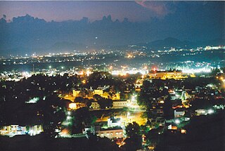
Vellore, also natively spelt as Velur, is a sprawling city and the administrative headquarters of Vellore district in the Indian state of Tamil Nadu. It is located on the banks of the Palar River in the northeastern part of Tamil Nadu and is separated into four zones that are further subdivided into 60 wards, covering an area of 153.14 km2 and housing a population of 315128 as reported by the 2011 census. It is located about 137.20 kilometres (85 mi) west of Chennai, and about 213.20 kilometres (132 mi) east of Bangalore. Vellore is located on the Mumbai–Chennai arm of the Golden Quadrilateral. Vellore is governed under a mayor and the Vellore Municipal Corporation. It is a part of both the Lok Sabha and state assembly constituencies of Vellore.

Vandavasi is a Municipality and Taluk in the Tiruvannamalai district of the Indian state of Tamil Nadu. The town is well known in the Carnatic history for the Battle of Wandiwash. Vandavasi town is also the largest manufacturer of kora artefacts including mats, shawls and vessels. As of 2011, the town had a population 74,320.
Walajapet is a municipality and taluk of Ranipet district in the state of Tamil Nadu.
Gudiyetram, colloquially Gudiyattam is a municipality in Vellore district in the state of Tamil Nadu in India. It lies between Bangalore and Chennai and the district of Vellore is 33 km away from the town. In 2011, the town had a population of 235,672. The municipality derives its name from 'Gudiye-tram' in Tamil which means habituation of people. The ancient occupation of the people of Guidyatham was handloom weaving.

Vellore district is one of the 38 districts in the Tamil Nadu state of India. It is one of the eleven districts that form the north region of Tamil Nadu. Vellore city is the headquarters of this district. As of 2011, the district had a population of 1,614,242 with a sex ratio of 1,007 females for every 1,000 males. In 2017 Vellore district ranked eleventh in list of districts in Tamil Nadu by Human Development Index.
Allapuram is a part of Vellore city in the state of Tamil Nadu in southern India.It is located on vellore's arterial road "Officer's lane" and also this locality is near to Vellore Central Prison.
Kalinjur is a locality in Vellore City in the Indian state of Tamil Nadu.It comes under the zone-2 of Vellore Municipal Corporation
Kaveripakkam is a town panchayat in Ranipet district, Vellore Region in the Indian state of Tamil Nadu.
Nallur (Nalloor) is a panchayat town in Kanniyakumari district in the Indian state of Tamil Nadu.
Palavansathu is a locality in Vellore City in the Indian state of Tamil Nadu. This locality of Vellore gives evidence that the area of Vellore was under the administrative control of the Pallava empire. The meaning of Palavansathu could be the corruption of two words Pallavan and Sarndha, thus Pallavan Sarnthu would have become Palavansathu over time.
South Nallur is a panchayat town in Tiruppur district in the Indian state of Tamil Nadu.
Sathuvachari is an area and Zone-II headquarters of Vellore Municipal Corporation. It is located in the east of Vellore city. It is situated in the bank of Palaar River.
Shenbakkam is a small locality adjoining with Konavattam locality and also zone-4 headquarters of Vellore Municipal Corporation in the Indian state of Tamil Nadu. The Swayambu Vinayagar temple is located here.
Thorapadi is a part of Vellore Corporation. It is a prominent area in the city of Vellore.
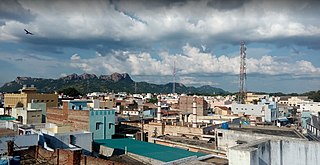
Aarani, officially spelled as Arni, and also known as Periya Aarani, is a major commercial, industrial and cultural hub and also a divisional headquarter in the Thiruvanamalai district of Tamil Nadu, India. The town is the second largest urban center next to the district headquarters, Thiruvannamalai, and is administered by a selection grade municipality. Aarani is home to silk weaving, spinning mills and agricultural industries. Famous Aarani silk and a paddy variety named Aarani Ponni, known for its rich aroma, originates from Aarani. The town is often nicknamed as The Silk City. Aarani also has a rich cultural heritage as it is a major center of Tamil Jainism.
Katpadi taluk is a taluk in Vellore district of the Indian state of Tamil Nadu. The headquarters of the taluk is the town of Katpadi.
Pernambut is a town and village headquarters also a Municipality in Vellore district in the Indian state of Tamil Nadu. The economy is dependent on leather tanning industry, earning it the nickname Leather Tanning city of Tamil Nadu. Pernambut is a municipality and headquarters of Pernambut Taluk which is an administrative division comprising 52 Revenue villages in the district of Vellore.
Kandipedu is a village in Katpadi, at the northern part of Vellore city in the Indian state of Tamil Nadu. It sits on the Katpadi-Vallimalai railway line, near Thiruvalluvar University, one of India's premier educational institutions.

Tirupathur or Tirupattur is the headquarters of Tirupathur district in the state of Tamil Nadu in India and is one of the oldest inhabited places in the state, with a history of over 1,600 years. The town is known for an abundance of sandalwood in the surrounding hills. It is located about 89 km (55 mi) from Vellore, 85 km (53 mi) from Hosur, 60 km (37 mi) from Dharmapuri, 50 km (31 mi) from Krishnagiri, 50 km (31 mi) from Thiruvannamalai, 279 km (173 mi) from coimbatore, 210 km (130 mi) from Chennai, and 125 km (78 mi) from Bangalore.
