Dierona

Last updated
Dierona

Διερώνα
View of Dierona 15.jpg
Cyprus relief location map.jpg
Red pog.svg
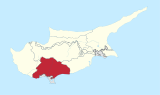
Dierona
Location in Cyprus
Coordinates: 34°49′49″N33°6′40″E / 34.83028°N 33.11111°E / 34.83028; 33.11111 Coordinates: 34°49′49″N33°6′40″E / 34.83028°N 33.11111°E / 34.83028; 33.11111
CountryFlag of Cyprus.svg  Cyprus
District Limassol District
Population
(2001) [1]
  Total258
Time zone UTC+2 (EET)
  Summer (DST) UTC+3 (EEST)

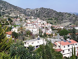
Dierona (Greek : Διερώνα) is a tiny semi-mountainous village in the Limassol District of Cyprus, located 2 km south of Arakapas at the foothills of the Troodos Mountains.

Greek language language spoken in Greece, Cyprus and Southern Albania

Greek is an independent branch of the Indo-European family of languages, native to Greece, Cyprus and other parts of the Eastern Mediterranean and the Black Sea. It has the longest documented history of any living Indo-European language, spanning more than 3000 years of written records. Its writing system has been the Greek alphabet for the major part of its history; other systems, such as Linear B and the Cypriot syllabary, were used previously. The alphabet arose from the Phoenician script and was in turn the basis of the Latin, Cyrillic, Armenian, Coptic, Gothic, and many other writing systems.

Limassol District District in Cyprus

Limassol District or Lemesos is one of the six districts of Cyprus. As of 2011, it had a population of 239.842, 77% of which was urban. Its main city is Limassol. Part of the British Overseas Territory of Akrotiri and Dhekelia forms an enclave on the Akrotiri Peninsula, under the sovereignty of the United Kingdom.

Cyprus Island country in Mediterranean

Cyprus, officially the Republic of Cyprus, is an island country in the Eastern Mediterranean and the third largest and third most populous island in the Mediterranean, located south of Turkey, west of Syria and Lebanon, northwest of Israel, north of Egypt, and southeast of Greece.

It boasts a glorious medley of water, mountains, and pretty-as-a picture little streets. The population, at the last count, is just over 250 people.

The village is close to the Wine Routes in the Commandaria area and stands at an altitude of 461 metres (1512.47 feet).

Commandaria is an amber-coloured sweet dessert wine made in the Commandaria region of Cyprus on the foothills of the Troödos mountains. Commandaria is made from sun-dried grapes of the varieties Xynisteri and Mavro. While often a fortified wine, through its production method it often reaches high alcohol levels, around 15%, already before fortification. It represents an ancient wine style documented in Cyprus back to 800 BC and has the distinction of being the world's oldest named wine still in production, with the name Commandaria dating back to the crusades in the 12th century.

It is especially noteworthy for the picturesque arched Venetian Dierona Bridge, the Church of Archangel Michael and lush mandarin orchards, walnut trees and picturesque wooded mountainscape.

The village is equidistant between the mountains and the seaside at Amathus in Limassol, and easily reachable by a modern dual-lane road.

There is a popular Golf and Country Club in nearby Vikla.


Related Research Articles

Pyrgos or Pyrgus may refer to:

Louvaras Place in Limassol District, Cyprus

Louvaras is a village in the Troödos Mountains of Cyprus. The village is 28 kilometers north of Limassol. Of interest are the frescos in the small medieval church of St Mamas, built in 1455 in the centre of the village. The hamlet of Athrakos is part of the municipality.

Paramytha Village in Limassol District, Cyprus

Paramytha is a village located north of Limassol on the foothills of the Troodos mountains. The tennis player Marcos Baghdatis was born in this village.

Ypsonas municipality of Limassol District, Republic of Cyprus

Ypsonas is a municipality in Limassol prefecture of the Republic of Cyprus. It is one of the largest villages in the Limassol District of Cyprus and is located about 7 kilometers west of Limassol city. The southern part of the village is within the administrative borders of the British military base of Akrotiri - Episkopi. It has 10,916 residents as recorded in the Census of 2011.

Erimi is a village lying partly in the Limassol District of Cyprus and partly in the British Overseas Territory of Akrotiri and Dhekelia. It has a population of 1,432 according to the 2001 census. It has recently increased in size with the addition of the district "Aphrodite Gardens", a new area just developed for expatriates of mainly British origin.

Agios Mamas, Limassol Place in Limassol, Cyprus

Agios Mamas is a small village in the Limassol region of Cyprus. It is located on the southern slopes of the Troodos mountain range in the area famous for its Commandaria wine.

Chandria Place in Limassol District, Cyprus

Chandria is a village in Cyprus in the Limassol administrative district and belongs to the Pitsilia group of villages. At an elevation of 1,275 m (4,180 ft), it is the second highest village in Cyprus after Prodromos.

Kato Platres Village in Limassol, Cyprus

Kato Platres also known as Tornarides is a mountainous village in Cyprus. It is located on the southern slopes of the Troödos Mountains and is one of the Krasochoria. Kato Platres is approximately 24 kilometers (15 mi) north-west of Limassol and 46 kilometers (29 mi) south-west of the capital Nicosia.

Bielle Commune in Nouvelle-Aquitaine, France

Bielle is a commune of the Pyrénées-Atlantiques department in southwestern France.

Vouni in Limassol District, Cyprus

Vouni is a small village in Limassol District, Cyprus, located 7 km north of Agios Therapon. The name of the village is derived from its location, in which Vouni means "low mountain" in Greek.

Kapilio in Limassol, Cyprus

Kapilio is a small village in the Limassol region of Cyprus. It is located in the area famous for its Commandaria wine, built on a slight elevation in the valley of the Ambelikos river to the east of the Troodos mountain range.

Nisou village in Nicosia District, Cyprus

Nisou is a village in the Nicosia District of Cyprus, just north of Pera Chorio and it is about 15 kilometres from the capital.

Palaiomylos Village in Limassol District, Cyprus

Palaiomylos, also called Paliomylos, is a village in the Limassol District of Cyprus, located 3 km south of Prodromos.

Kouka, Cyprus village in Limassol District, Cyprus

Kouka is a small village in the Limassol District of Cyprus, in the foothills of the Troodos Mountains on the western slopes of the Kouris Valley.

Koilani in Limassol District, Cyprus

Koilani is a village in the Limassol District of Cyprus, located 3 km south of Pera Pedi.

Foinikaria village in Limassol District, Cyprus

Foinikaria is a village in the Limassol District of Cyprus, located east of the Germasogeia Dam. It is approximately a 7 kilometres drive from the Germasogeia roundabout, which is located on the Limassol – Nicosia and Limassol – Paphos Highway. It is a 10-minute drive to the sandy beach coast of the City of Limassol and a 15-minute drive to the city center and surroundings where all amenities can be found.

Mályinka is a village in Borsod-Abaúj-Zemplén County in northeastern Hungary. Has road connection to the near Dédestapolcsány, Tardona, Nagyvisnyó. The closest town is Kazincbarcika.

Mogyoróska is a village in Borsod-Abaúj-Zemplén County in northeastern Hungary. Near to Regéc in the Zemplén Mountains. Because of the picturesque landscape the village is on the path of the National Blue Trail.

References

  1. Census 2001