An impact crater is an approximately circular depression in the surface of a planet, moon, or other solid body in the Solar System or elsewhere, formed by the hypervelocity impact of a smaller body. In contrast to volcanic craters, which result from explosion or internal collapse, impact craters typically have raised rims and floors that are lower in elevation than the surrounding terrain. Impact craters range from small, simple, bowl-shaped depressions to large, complex, multi-ringed impact basins. Meteor Crater is a well-known example of a small impact crater on Earth.

A cruise missile is a guided missile used against terrestrial targets that remains in the atmosphere and flies the major portion of its flight path at approximately constant speed. Cruise missiles are designed to deliver a large warhead over long distances with high precision. Modern cruise missiles are capable of travelling at supersonic or high subsonic speeds, are self-navigating, and are able to fly on a non-ballistic, extremely low-altitude trajectory.

The Weser is a river in Northwestern Germany. Formed at Hannoversch Münden by the confluence of the rivers Fulda and Werra, it flows through Lower Saxony, then reaching the Hanseatic city of Bremen, before emptying 50 km (31 mi) further north at Bremerhaven into the North Sea. On the opposite (west) bank is the town of Nordenham at the foot of the Butjadingen Peninsula; thus, the mouth of the river is in Lower Saxony. The Weser has an overall length of 452 km (281 mi). Together with its Werra tributary, which originates in Thuringia, its length is 744 km (462 mi).

A Low Earth Orbit (LEO) is an Earth-centered orbit with an altitude of 2,000 km (1,200 mi) or less, or with at least 11.25 periods per day and an eccentricity less than 0.25. Most of the manmade objects in space are in LEO. A histogram of the mean motion of the cataloged objects shows that the number of objects drops significantly beyond 11.25.

The international E-road network is a numbering system for roads in Europe developed by the United Nations Economic Commission for Europe (UNECE). The network is numbered from E 1 up and its roads cross national borders. It also reaches Central Asian countries like Kyrgyzstan, since they are members of the UNECE.

High-speed rail (HSR) is a type of rail transport that operates significantly faster than traditional rail traffic, using an integrated system of specialized rolling stock and dedicated tracks. While there is no single standard that applies worldwide, new lines in excess of 250 kilometres per hour (160 mph) and existing lines in excess of 200 kilometres per hour (120 mph) are widely considered to be high-speed, with some extending the definition to include lower speeds in areas for which these speeds still represent significant improvements. The Tōkaidō Shinkansen, the first such system, began operations in Japan in 1964 and was widely known as the bullet train. High-speed trains normally operate on standard gauge tracks of continuously welded rail on grade-separated right-of-way that incorporates a large turning radius in its design.

The Trans-Canada Highway is a transcontinental federal-provincial highway system that travels through all ten provinces of Canada from the Pacific Ocean on the west to the Atlantic on the east. The main route spans 7,821 km (4,860 mi) across the country, one of the longest routes of its type in the world. The highway system is recognizable by its distinctive white-on-green maple leaf route markers, although there are small variations in the markers in some provinces.
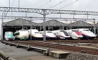
The Shinkansen, meaning new trunkline, but colloquially known in English as the bullet train, is a network of high-speed railway lines in Japan. Initially, it was built to connect distant Japanese regions with Tokyo, the capital, in order to aid economic growth and development. Beyond long-distance travel, some sections around the largest metropolitan areas are used as a commuter rail network. It is operated by five Japan Railways Group companies.

The Ordnance Survey National Grid reference system is a system of geographic grid references used in Great Britain, distinct from latitude and longitude. It is often called British National Grid (BNG).

An ultramarathon, also called ultra distance or ultra running, is any footrace longer than the traditional marathon length of 42.195 kilometres (26.219 mi).
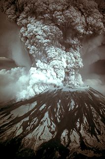
On May 18, 1980, a major volcanic eruption occurred at Mount St. Helens, a volcano located in Skamania County, in the U.S. state of Washington. The eruption was the most significant volcanic eruption to occur in the contiguous 48 U.S. states since the much smaller 1915 eruption of Lassen Peak in California. It has often been declared the most disastrous volcanic eruption in U.S. history. The eruption was preceded by a two-month series of earthquakes and steam-venting episodes, caused by an injection of magma at shallow depth below the volcano that created a large bulge and a fracture system on the mountain's north slope.

|The National Highways network of India is a network of trunk roads that is owned by the Ministry of Road Transport and Highways. It is constructed and managed by the National Highway Authority of India (NHAI), the National Highways and Infrastructure Development Corporation (NHIDCL), and the public works departments (PWDs) of state governments. NHAI was established by the National Highways Authority of India Act, 1988. Section 16(1) of the Act states that the function of NHAI is to develop, maintain, and manage the National Highways and any other highways vested in, or entrusted to, it by the Government of India. These highways as of April 2019 measure over 142,126 km (88,313 mi). The Indian government has vowed to double the highway length from 96,000 to 2,00,000 km.

Cycle sport is competitive physical activity using bicycles. There are several categories of bicycle racing including road bicycle racing, time trialling, cyclo-cross, mountain bike racing, track cycling, BMX, and cycle speedway. Non-racing cycling sports include artistic cycling, cycle polo, freestyle BMX and mountain bike trials. The Union Cycliste Internationale (UCI) is the world governing body for cycling and international competitive cycling events. The International Human Powered Vehicle Association is the governing body for human-powered vehicles that imposes far fewer restrictions on their design than does the UCI. The UltraMarathon Cycling Association is the governing body for many ultra-distance cycling races.

The Bugatti Veyron EB 16.4 is a mid-engine sports car, designed and developed in Germany by the Volkswagen Group and manufactured in Molsheim, France, by French automobile manufacturer Bugatti. It was named after the racing driver Pierre Veyron.
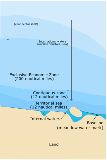
An exclusive economic zone (EEZ) is a sea zone prescribed by the United Nations Convention on the Law of the Sea over which a state has special rights regarding the exploration and use of marine resources, including energy production from water and wind. It stretches from the baseline out to 200 nautical miles (nmi) from its coast. In colloquial usage, the term may include the continental shelf. The term does not include either the territorial sea or the continental shelf beyond the 200 nmi limit. The difference between the territorial sea and the exclusive economic zone is that the first confers full sovereignty over the waters, whereas the second is merely a "sovereign right" which refers to the coastal state's rights below the surface of the sea. The surface waters, as can be seen in the map, are international waters.

Racewalking, or race walking, is a long-distance discipline within the sport of athletics. Although it is a foot race, it is different from running in that one foot must appear to be in contact with the ground at all times. This is assessed by race judges. Typically held on either roads or on running tracks, common distances vary from 3000 metres (1.8 mi) up to 100 kilometres (62.1 mi).

The Kolkata Metro is a rapid transit system serving the Kolkata metropolitan area in the Indian state of West Bengal. The network currently consists of one operational line of 27.22 km from Noapara to Kavi Subhash with five other lines in various phases of construction. The Kolkata Metro was the first metro railway in India, opening for commercial services from 1984. It is the sixth longest operational metro network in India after the Delhi Metro, Hyderabad Metro, Chennai Metro, Namma Metro and Noida Metro. On 29 December 2010, Metro Railway, Kolkata became the 17th zone of the Indian Railways, operated by the Ministry of Railways. There are 300 metro services daily carrying over 700,000 passengers making it the second busiest metro system in India.

The National Engineering and Scientific Commission (NESCOM) is a civilian controlled scientific and engineering organization of Pakistan, responsible for carrying out research and development in many areas including information technology, fluid dynamics, aerodynamics, aerospace engineering, electrical engineering, mechanical engineering and chemical engineering, with specialties in the design and production of communication systems and aerodynamic vehicles for the Pakistan Armed Forces. It is under the administrative control of the Strategic Plans Division of Pakistan's National Command Authority and is headquartered in Islamabad, Pakistan.
National Highway 44 is the longest-running major north–south National Highway in India. It begins from Srinagar and terminates in Kanyakumari; the highway passes through the states of Jammu & Kashmir, Punjab, Haryana, Delhi, Uttar Pradesh, Madhya Pradesh, Maharashtra, Telangana, Andhra Pradesh, Karnataka, and Tamil Nadu. NH-44 was laid and is maintained by Central Public Works Department (CPWD).