
Polis is a town at the north-west end of the island of Cyprus, at the centre of Chrysochous Bay, and on the edge of the Akamas peninsula nature reserve.
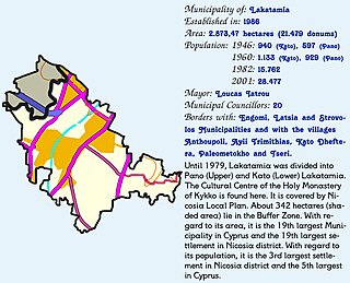
Lakatamia is a southwestern suburb of Nicosia, Cyprus. In terms of population, Lakatamia municipality is the third largest municipality in Nicosia district and the fifth largest municipality in Cyprus. In 2011 Lakatamia had a population of 38,345.
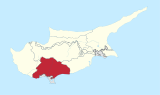
Geroskipou is a coastal village in Cyprus, east of Paphos. Its current population is approximately 7,000 and it is the second largest municipality in the Paphos District. Yeroskipou, with its remarkable five-domed Byzantine church of Agia Paraskevi, and its Folk Art Museum, is a popular tourist destination. It is known especially for the production of the confectionery "lokum". The town is the only place in the world which has protected geographical indication (PGI) for the popular dessert.
Maroni is a village located in the Larnaca District of Cyprus.
Astromeritis is a large village in the Morphou Department of the Nicosia District of Cyprus. It is located 30 km (18.64 mi) from the capital Nicosia. At the 2011 census it had a population of 2,307.

Kotsiatis is a village located in the Nicosia District of Cyprus.

Mathiatis is a village located in the Nicosia District of Cyprus. Before 1960, it had a mixed Greek- and Turkish-Cypriot population.
Agios Theodoros Skarinou is a village located in the Larnaca District of Cyprus, 6 km from the sea and 3 km from the village of Kofinou. Its population in 2011 was 663.
Kalo Chorio Larnakas is a village located in the Larnaca District of Cyprus, 10 km west of the town of Larnaca. Prior to 1974, the majority of the village consisted of Turkish Cypriots.
Sia or Sha is a village in the Nicosia District of Cyprus. It is located 4 km south of Alampra.

Deneia is a village in the Nicosia District of Cyprus, west of Mammari. It is one of only four villages located within the United Nations Buffer Zone, the other three being Pyla, Athienou and Troulloi.
Kellia is a village in the Larnaca District of Cyprus, located north of Larnaca. Prior to 1974, the village was inhabited mostly by Turkish Cypriots. In 2011, its population was 387.
Softades is a village in the Larnaca District of Cyprus, located 3 km west of Kiti. Prior to 1964 the village was inhabited almost exclusively by Turkish Cypriots.

Alethriko is a village in the Larnaca District of Cyprus, west of Larnaca. The first known census was carried out under Ottoman Rule in 1831; it listed only males: there were 46 Greek Cypriots and 18 Turkish Cypriots. In the census of 1891 the population of Alethriko was recorded as 37 Turkish Cypriots and 233 Greek Cypriots of both sexes. In 2011 its population was 1,101.
Agia Anna is a village in the Larnaca District of Cyprus, 16 km west of Larnaca. Its population in 2011 was 339.
Menogeia is a village in the Larnaca District of Cyprus, located 2 km west of Anglisides. In 2011, it had a population of 50.

Choirokoitia is a village in the Larnaca District of Cyprus, located 2 km north of Tochni, near the UN World Heritage Site of Choirokoitia.

Psematismenos is a village in the Larnaca District of Cyprus, located 2 km northwest of Maroni.

Mari is a village in the Larnaca District of Cyprus, located 5 km west of Zygi. The village was largely populated by Turkish Cypriots before 1974. In Turkish, it is known as Tatlısu.
Lageia is a small village in the Larnaca District of Cyprus, 7 km west of Pano Lefkara. Its population in 2011 was 28.