
Nubians are a Nilo-Saharan speaking ethnic group indigenous to the region which is now northern Sudan and southern Egypt. They originate from the early inhabitants of the central Nile valley, believed to be one of the earliest cradles of civilization. In the southern valley of Egypt, Nubians differ culturally and ethnically from Egyptians, although they intermarried with members of other ethnic groups, especially Arabs. They speak Nubian languages as a mother tongue, part of the Northern Eastern Sudanic languages, and Arabic as a second language.
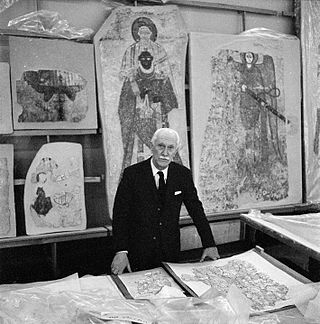
Nubiology is the scientific study of ancient Nubia. The term was coined by Kazimierz Michałowski.

Wādī Ḥalfā is a city in the Northern state of Sudan on the shores of Lake Nubia near the border with Egypt. It is the terminus of a rail line from Khartoum and the point where goods are transferred from rail to ferries going down the lake. As of 2007, the city had a population of 15,725. The city is located amidst numerous ancient Nubian antiquities and was the focus of much archaeological work by teams seeking to save artifacts from the flooding caused by the completion of the Aswan Dam.
Wadi Allaqi, also transliterated as Wadi Allaqui or Wadi Alalaqi, is a wadi in southern Egypt. It begins in Sudan below the Halaib Triangle, and its mouth is south of Aswan on the eastern shore of Lake Nasser.
Banu Kanz, also known as Awlad Kanz, was a semi-nomadic Muslim dynasty of Arab descent that ruled the border region between Upper Egypt and Nubia between the 10th and 15th centuries. They were descended from the sons of sheikhs of the Arab Banu Hanifa tribe who intermarried with the princesses of the Beja Hadariba tribe. They gained official control over the region of Aswan, Wadi Allaqi and the frontier zone in the early 11th century when their chief, Abu al-Makarim Hibatallah, captured a major rebel on behalf of the Fatimid authorities. Abu al-Makarim was accorded the title Kanz al-Dawla by Caliph al-Hakim and his successors inherited the title. The Banu Kanz entered into conflict with the Ayyubids in 1174, during which they were defeated and forced to migrate southward into northern Nubia, where they helped accelerate the expansion of Islam in the mostly Christian region. They eventually assumed control of the Nubian Kingdom of Makuria in the early 14th century, but by the early the 15th century, they were supplanted by the Hawwara tribesmen dispatched by the Mamluks to combat the Banu Kanz. Their modern-day descendants are a Sudanese tribe known as the "Kunuz", who live in the far north of the country.

Lower Nubia is the northernmost part of Nubia, roughly contiguous with the modern Lake Nasser, which submerged the historical region in the 1960s with the construction of the Aswan High Dam. Many ancient Lower Nubian monuments, and all its modern population, were relocated as part of the International Campaign to Save the Monuments of Nubia; Qasr Ibrim is the only major archaeological site which was neither relocated nor submerged. The intensive archaeological work conducted prior to the flooding means that the history of the area is much better known than that of Upper Nubia. According to David Wengrow, the A-Group Nubian polity of the late 4th millenninum BCE is poorly understood since most of the archaeological remains are submerged underneath Lake Nasser.

The Kingdom of Kerma or the Kerma culture was an early civilization centered in Kerma, Sudan. It flourished from around 2500 BC to 1500 BC in ancient Nubia. The Kerma culture was based in the southern part of Nubia, or "Upper Nubia", and later extended its reach northward into Lower Nubia and the border of Egypt. The polity seems to have been one of a number of Nile Valley states during the Middle Kingdom of Egypt. In the Kingdom of Kerma's latest phase, lasting from about 1700 to 1500 BC, it absorbed the Sudanese kingdom of Sai and became a sizable, populous empire rivaling Egypt. Around 1500 BC, it was absorbed into the New Kingdom of Egypt, but rebellions continued for centuries. By the eleventh century BC, the more-Egyptianized Kingdom of Kush emerged, possibly from Kerma, and regained the region's independence from Egypt.
The C-Group culture is an archaeological culture found in Lower Nubia, which dates from c. 2400 BCE to c. 1550 BCE. It was named by George A. Reisner. With no central site and no written evidence about what these people called themselves, Reisner assigned the culture a letter. The C-Group arose after Reisner's A-Group and B-Group cultures, and around the time the Old Kingdom was ending in Ancient Egypt.
Buhen, alternatively known as Βοὥν (Bohón) in Ancient Greek, stands as a significant ancient Egyptian settlement on the western bank of the Nile, just below the Second Cataract in present-day Northern State, Sudan. Its origins trace back to the Old Kingdom period, where it served as an Egyptian colonial town, particularly recognized for copper smelting. In 1962, archaeological discoveries brought to light an ancient copper manufacturing facility encircled by an imposing stone barrier, indicating its origin during the rule of Sneferu in the 4th Dynasty. Inscriptions and graffiti disclosed a continuous Egyptian presence spanning two centuries, only to be interrupted by migration from the southern regions in the 5th Dynasty.

The region of Semna is 15 miles south of Wadi Halfa and is situated where rocks cross the Nile narrowing its flow—the Semna Cataract.

Mining in Egypt has had a long history that dates back to predynastic times. Active mining began in Egypt around 3000 BCE. Egypt has substantial mineral resources, including 48 million tons of tantalite, 50 million tons of coal, and an estimated 6.7 million ounces of gold in the Eastern Desert. The total real value of minerals mined was about E£102 million (US$18.7 million) in 1986, up from E£60 million (US$11 million) in 1981. The chief minerals in terms of volume output were iron ore, phosphates, and salt. The quantities produced in 1986 were estimated at 2,048, 1,310, and 1,233 tons, respectively, compared with 2,139, 691, and 883 tons in 1981. In addition, minor amounts of asbestos (313 tons) and quartz (19 tons) were mined in 1986. Preliminary exploration in Sinai indicated the presence of zinc, tin, lead, and copper deposits. Private sector exploration and exploitation activities so far have been limited. Only recently, AngloGold Ashanti with its joint Venture Partner Thani Dubai and a Canadian listed exploration company, Alexander Nubia International have been undertaking exploration in Egypt's Eastern Desert with some success. Centamin Ltd., a mineral exploration company founded in Australia, started a massive mining project in Sukari Hill.

Uronarti, a Nubian word meaning "Island of the King", is an island in the Nile just south of the Second Cataract in the north of Sudan. The primary importance of the island lies in the massive ancient fortress that still stands on its northern end. This fortress is one of a number constructed along the Nile in Lower Nubia during the Middle Kingdom, primarily by the rulers Senusret I and Senusret III.

Nubia is a region along the Nile river encompassing the confluence of the Blue and White Niles, and the area between the first cataract of the Nile or more strictly, Al Dabbah. It was the seat of one of the earliest civilizations of ancient Africa, the Kerma culture, which lasted from around 2500 BC until its conquest by the New Kingdom of Egypt under Pharaoh Thutmose I around 1500 BC, whose heirs ruled most of Nubia for the next 400 years. Nubia was home to several empires, most prominently the Kingdom of Kush, which conquered Egypt in the eighth century BC during the reign of Piye and ruled the country as its 25th Dynasty.

Usersatet was an Ancient Egyptian official with the titles king's son of Kush and overseer of the southern countries. He was in office under king Amenhotep II and perhaps in the early years of the reign of Thutmosis IV. As king's son of Kush he was the main official in charge of the Nubian provinces.

Askut was an ancient Egyptian island fortress in the Middle Kingdom on the Nile, which was built for the purpose of securing the border to Nubia. Since the completion of the Aswan High Dam, the island has been flooded with Lake Nubia.
Tombos or Tumbus is an archaeological site in northern Sudan, including Tombos island and the nearby riverbank area. Tombos is located at the Third Cataract of the Nile and on the northern margin of the Dongola Reach, not far from Kerma. The occupation of Tombos, revealed by archaeological work, began in mid-18th Dynasty of Egypt and continued through the 25th Dynasty. In the New Kingdom period, a large range of pharaonic and private royal inscriptions from 18th Dynasty and elite tombs in Egyptian style indicates Tombos was an important node of Egyptian colonial control. In the New Kingdom, Tombos witnessed the blending and entanglement of Egyptian and Nubian traditions.

Mirgissa was a settlement in Northern state, Sudan. Situated at the 2nd cataract in Wadi Halfa, it contained one of the largest fortresses in Nubia. In the time of Thutmose II, 250 to 450 people inhabited the area. The first European explorer was English geologist Sir Henry George Lyons in 1892, and was excavated without Sudanese permission, by the French Egyptologist Jean Vercoutter from 1962 to 1969. In addition to the fort, excavations uncovered the remains of two cities, one of which was fortified, a northern enclosure, two cemeteries, a boat slide, and a port. Construction of the Aswan High Dam caused the disappearance of Mirgissa, which now lies under the waters of Lake Nubia.
Wadi el-Hudi is a mining region that includes a large wadi and a mountain named Gebel el-Hudi in the Egyptian Eastern Desert, Southeast of Aswan. The name hudi is thought to come from the Arabic word for guide. Wadi el-Hudi is geologically rich and has been the basis of considerable mining and study since Ancient times. While it was initially known for the ancient amethyst quarries, this area is important the study of Egyptian archaeology and history because of its high number of rock inscriptions, stele, settlements, and mines, mainly dating to the Middle Kingdom. This area is fairly large, about 100 square kilometers.

The International Campaign to Save the Monuments of Nubia was the effort to relocate 22 monuments in Lower Nubia, in Southern Egypt and northern Sudan, between 1960 and 1980. This was done in order to make way for the building of the Aswan Dam, at the Nile's first cataract, a project launched following the 1952 Egyptian Revolution. This project was undertaken under UNESCO leadership and a coalition of fifty countries. This process led to the creation of the World Heritage Convention in 1972, and thus the system of UNESCO World Heritage Sites.

Gebel Adda was a mountain and archaeological site on the right bank of the Nubian Nile in what is now southern Egypt. The settlement on its crest was continuously inhabited from the late Meroitic period to the Ottoman period, when it was abandoned by the late 18th century. It reached its greatest prominence in the 14th and 15th centuries, when it seemed to have been the capital of late kingdom of Makuria. The site was superficially excavated by the American Research Center in Egypt just before being flooded by Lake Nasser in the 1960s, with much of the remaining excavated material, now stored in the Royal Ontario Museum in Canada, remaining unpublished. Unearthed were Meroitic inscriptions, Old Nubian documents, a large amount of leatherwork, two palatial structures and several churches, some of them with their paintings still intact. The nearby ancient Egyptian rock temple of Horemheb, also known as temple of Abu Oda, was rescued and relocated.
