
Thiruvananthapuram, formerly known as Trivandrum, is the capital city of the Indian state of Kerala. It is the largest and most populous city in Kerala. The encompassing urban agglomeration population is around 1.68 million. Located on the west coast of India near the extreme south of the mainland, Thiruvananthapuram is a major information technology hub in Kerala and contributes 55% of the state's software exports as of 2016. Referred to by Mahatma Gandhi as the "Evergreen city of India", the city is characterised by its undulating terrain of low coastal hills.

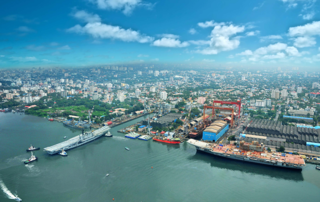
Kochi, also known by its former name Cochin, is a major port city along the Malabar Coast of India bordering the Laccadive Sea. It is part of the district of Ernakulam in the state of Kerala. The city is also commonly referred to as Ernakulam. As of 2011, the Kochi Municipal Corporation had a population of 677,381 over an area of 94.88 km2, and the larger Kochi urban agglomeration had over 2.1 million inhabitants within an area of 440 km2, making it the largest and the most populous metropolitan area in Kerala. Kochi city is also part of the Greater Cochin development region and is classified as a Tier-II city by the Government of India. The civic body that governs the city is the Kochi Municipal Corporation, which was constituted in the year 1967, and the statutory bodies that oversee its development are the Greater Cochin Development Authority (GCDA) and the Goshree Islands Development Authority (GIDA).
Nilambur is a major town, a municipality and a Taluk in the Malappuram district of the Indian state of Kerala. It is located close to the Nilgiris range of the Western Ghats on the banks of the Chaliyar River. This place is also known as 'Teak Town' because of the abundance of Nilambur teaks, which is a variety of a large, deciduous tree that occurs in mixed hardwood forests. Unlike many Municipalities of India; Nilambur is covered with large amounts of vegetation, making it very scenic.

Thiruvananthapuram District is the southernmost district in the Indian state of Kerala. The district was created in 1949, with its headquarters in the city of Thiruvananthapuram, which is also Kerala's administrative centre. The present district was created in 1956 by separating the four southernmost Taluks of the erstwhile district to form Kanyakumari district. The city of Thiruvananthapuram is also known as the Information technology capital of the State, since it is home to the first and largest IT park in India, Technopark, established in 1990. The district is home to more than 9% of total population of the state.

Periyar National Park and Wildlife Sanctuary (PNP) is a protected area located in the districts of Pathanamthitta and Idukki in Kerala, India. It is a renowned Elephant and Tiger reserve. The protected area encompasses 925 km2 (357 sq mi), of which 305 km2 (118 sq mi) of the main zone was declared as the Periyar National Park in 1982. The park is a repository of rare, endemic, and endangered flora and fauna and forms the major watershed of two important rivers of Kerala: the Periyar and the Pamba.

Achankovil is a 128 km (80 mi) long west flowing river in Kerala, India. It flows through the districts of Kollam, Pathanamthitta and Alappuzha. The river drains vast tract of fertile plains of Upper Kuttanad in the Alappuzha and Pathanamthitta districts. It also sustains numerous urban settlements along its course such as Konni, Pathanamthitta, Pandalam and Mavelikkara.

Kayamkulam is a municipality in the Alappuzha district of Kerala, India. It is located 46 km (28.6 mi) south of the district headquarters in Alappuzha and about 110 km (68.4 mi) north of the state capital Thiruvananthapuram. As per the 2011 Indian census, Kayamkulam has a population of 68,634 people, and a population density of 3,149/km2 (8,160/sq mi).
The economy of Kerala is the 9th largest in India, with an annual gross state product (GSP) of ₹9.78 lakh crore in 2020–2021. Per-capita GSP of Kerala during the same period is ₹257,711 (US$3,100), the sixth largest in India. In 2019–20, the tertiary sector contributed around 63% of the state's GSVA, compared to 28% by secondary sector, and 8% by primary sector.
Vagamon is an Indian hill station and a revenue village located in Peerumedu Taluk of Idukki district, and also Meenachil taluk and Kanjirappally taluk of Kottayam district in the state of Kerala, India. Located in the Western Ghats 25 kilometres (16 mi) east of Erattupetta on the border of Kottayam-Idukki districts, Vagamon is famous for its natural beauty. The Vagamon glass bridge is the longest cantilever glass bridge in India.
Kerala, called Keralam in Malayalam, is a state on the Malabar Coast of India. It was formed on 1 November 1956, following the passage of the States Reorganisation Act, by combining Malayalam-speaking regions of the erstwhile regions of Cochin, Malabar, South Canara, and Travancore. Spread over 38,863 km2 (15,005 sq mi), Kerala is the 21st largest Indian state by area. It is bordered by Karnataka to the north and northeast, Tamil Nadu to the east and south, and the Lakshadweep Sea to the west. With 33 million inhabitants as per the 2011 census, Kerala is the 13th-largest Indian state by population. It is divided into 14 districts with the capital being Thiruvananthapuram. Malayalam is the most widely spoken language and is also the official language of the state.

Pathanamthitta, is a municipality situated in the Southern Kerala, India, spread over an area of 23.50 km2. It is the administrative capital of Pathanamthitta district. The town has a population of 37,538. The Hindu pilgrim centre Sabarimala is situated in the Pathanamthitta district; as the main transport hub to Sabarimala, the town is known as the 'Pilgrim Capital of Kerala'. Pathanamthitta District, the thirteenth revenue district of the State of Kerala, was formed with effect from 1 November 1982, with headquarters at Pathanamthitta. Forest covers more than half of the total area of the District. Pathanamthitta District ranks the 7th in area in the State. The district has its borders with Allepey, Kottayam, Kollam and Idukki districts of Kerala and Tamil Nadu. Nearest town is Thiruvalla, located at a distance of 30 km. Thiruvalla railway station is 30 km via Thiruvalla-Kumbazha highway. Buses ply every 5 Minutes from Thiruvalla To Pathanamthitta & vice versa.

The United Democratic Front (UDF) is the Indian National Congress-led alliance of centre to centre-right political parties in the Indian state of Kerala. It is one of the two major political alliances in Kerala, the other being Communist Party of India (Marxist)-led Left Democratic Front, each of which has been in power alternately since 1980 E. K. Nayanar ministry. Most of the United Democratic Front constituents are members of the Indian National Congress-led Indian National Developmental Inclusive Alliance at pan-India level.

Kerala, a state in Southern India, has a network of 11 National Highways, 72 State Highways and many district roads.

The Kerala Co-operative Milk Marketing Federation (KCMMF), known by its trade name Milma, is a state government cooperative society established in 1980 headquartered in Thiruvananthapuram. It is an India state government cooperative owned by the Ministry of Cooperation, Government of Kerala. KCMMF is a Federation of three Regional Milk Unions: the ERCMPU, TRCMPU and MRCMPU.

N. K. Premachandran is an Indian politician who is a member of the Revolutionary Socialist Party. He is presently a member of Lok Sabha representing Kollam Lok Sabha constituency.

Ezhome is a census town in Kannur district in the Indian state of Kerala.

Government Medical College, Kollam, formerly ESIC Medical College, Parippally, is the first Government medical college in Kollam district, Kerala, India. It is situated 21 km (13 mi) south of Kollam city and 9.6 km (6.0 mi) east of Paravur town. The College was initially established by the Employees State Insurance Corporation, a Government of India establishment, and later acquired by the Government of Kerala.

Arya Vaidya Sala, popularly known as Kottakkal Arya Vaidya Sala, is a healthcare centre located in Kottakkal, in the Indian state of Kerala, providing services under the Indian traditional medicine system of Ayurveda.

Jatayu Earth Center, also known as Jatayu Nature Park or Jatayu Rock, is a park and tourism centre at Chadayamangalam in Kollam district of Kerala, India. It stands at an altitude of 350m (1200ft) above the mean sea level. Jatayu Nature Park holds the distinction of having the world’s largest bird sculpture, which is of Jatayu.

Very Severe Cyclonic Storm Ockhi was a strong tropical cyclone that devastated parts of Sri Lanka and India in 2017, and was the most intense tropical cyclone in the Arabian Sea since Cyclone Megh in 2015. The ninth depression, and the third and strongest named storm of the 2017 North Indian Ocean cyclone season, Ockhi originated from an area of low pressure that formed over the southwest Bay of Bengal on November 28. The storm organized into a Depression off southeast coast of Sri Lanka on November 29, causing damage to property and life in Sri Lanka while passing by. Due to high atmospheric moisture and warmer oceanic surface temperature between Sri Lanka and Kanyakumari in mainland India, Ockhi intensified into a cyclonic storm on November 30.