This article needs additional citations for verification .(August 2012) |
Blathur | |
|---|---|
village | |
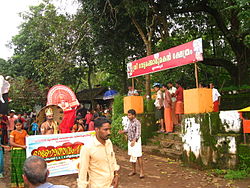 Onam at Blathur | |
 | |
| Coordinates: 11°59′20″N75°34′54″E / 11.98889°N 75.58167°E | |
| Country | |
| State | Kerala |
| District | Kannur |
| Languages | |
| • Official | Malayalam, English |
| Time zone | UTC+5:30 (IST) |
| PIN | 670593 |
| Telephone code | 91-(0)4602 |
| ISO 3166 code | IN-KL |
| Assembly Constituency | Mattannur |
| Lok Sabha Constituency | Kannur |
| Panchayath | Padiyur Grama Panchayath |
Blathur is a village in Kannur, Kerala, India, located approximately 38 kilometres north-east of the district headquarters, Kannur. The nearest town, Irikkur, is estimated to be 7 kilometres from the village itself. Blathur is situated in the Padiyoor Grama Panchayat in Iritty Taluk, on the edge of an estimated 90 acre paddy field, and is 169 meters above sea level. The area is rich in laterite rocks, and the main industry is based on laterite stone mining and agriculture.


