This is a list of the extreme points of the United Kingdom: the points that are farther north, south, east or west than any other location. Traditionally the extent of the island of Great Britain has stretched "from Land's End to John o' Groats".
The Queen Alexandra Range is a major mountain range about 100 nautical miles long, bordering the entire western side of Beardmore Glacier from the Polar Plateau to the Ross Ice Shelf. The range is in the Transantarctic Mountains System, and is located in the Ross Dependency region of Antarctica.
The Britannia Range is a range of mountains bounded by the Hatherton Glacier and Darwin Glacier on the north and the Byrd Glacier on the south, westward of the Ross Ice Shelf in Antarctica.

James Ross Island is a large island off the southeast side and near the northeastern extremity of the Antarctic Peninsula, from which it is separated by Prince Gustav Channel. Rising to 1,630 metres (5,350 ft), it is irregularly shaped and extends 40 nautical miles in a north–south direction.
The Aviator Glacier is a major valley glacier in Antarctica that is over 60 nautical miles long and 5 nautical miles wide, descending generally southward from the plateau of Victoria Land along the west side of Mountaineer Range, and entering Lady Newnes Bay between Cape Sibbald and Hayes Head where it forms a floating tongue.
Sky+ HD was the brand name of the HDTV service launched by Sky plc on 22 May 2006 in the United Kingdom and Ireland to enable high definition channels on Sky to be viewed. For the first two years after launch, the service was branded Sky HD. The service requires the user to have a Sky+ HD Digibox and an HD ready TV. A subscription to the original HD pack carries an extra fee of £10.25 a month in addition to the standard Sky subscription, allowing customers to view HD channels corresponding to the channel packs subscribed to. Additional Pay-Per-View events on Sky Box Office HD are not available to customers unless they subscribe to the Sky HD pack.
Pech Chenda is a khum (commune) of Phnum Proek district in the Battambang province in north-western Cambodia.
The Mariner Glacier is a major glacier over 60 nautical miles long, descending southeast from the plateau of Victoria Land, Antarctica, between Mountaineer Range and Malta Plateau, and terminating at Lady Newnes Bay, Ross Sea, where it forms the floating Mariner Glacier Tongue.

The Adare Peninsula, is a high ice-covered peninsula, 40 nautical miles long, in the northeast part of Victoria Land, extending south from Cape Adare to Cape Roget. The peninsula was named by the New Zealand Antarctic Place-Names Committee (NZ-APC) for Cape Adare. The peninsula is considered the southernmost point of the Borchgrevink Coast, named for Carsten Borchgrevink (1864-1934).
Somé is a town in the Nandiala Department of Boulkiemdé Province in central western Burkina Faso. It has a population of 3,073.

Ébano is a town and municipality in the Mexican state of San Luis Potosí in central Mexico. It is located in the eastern corner of the state, on the border with Veracruz, in the Huasteca region. Its name comes from the Spanish word for ebony.
Villa de Pomán is a town and municipality in Catamarca Province in northwestern Argentina.

Karujärve is a village in Saaremaa Parish, Saare County in western Estonia.

Stinker Point is a headland 7 km (4.3 mi) south of Table Bay and 2.2 km (1.4 mi) northwest of Piperkov Point on the west coast of Elephant Island, in the South Shetland Islands of Antarctica. It was mapped by the UK Joint Services Expedition to Elephant Island, 1970–71, and named after the southern giant petrels which breed there, "stinker" being an old sailors' name for the bird.
Strauss Glacier is a glacier, 40 nautical miles long, flowing between the Ickes Mountains and Coulter Heights to enter the sea at the east side of Land Bay, Marie Byrd Land, Antarctica.
Planet Heights is a series of summits running along an ice-free ridge, extending 24 nautical miles (44 km) in a north-south direction between the southernmost extremity of the LeMay Range and George VI Sound in the east part of Alexander Island, Antarctica. Many landforms and nearby features are named in association with this mountain range; some of these include landforms named after astronomers, satellites, planets and other things related to astrology and astrophysics. The mountain range was first mapped from air photos taken by the Ronne Antarctic Research Expedition (RARE), 1947–48, by Searle of the Falkland Islands Dependencies Survey (FIDS) in 1960. Named by the United Kingdom Antarctic Place-Names Committee (UK-APC) from association with the nearby glaciers named for planets of the Solar System. The only planet that is not featured in any of these glaciers is the planet Earth, as there are no glaciers named "Earth Glacier" and this glacier does not exist.
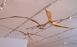
The Caelidracones is a group of pterosaurs.

Fluclotizolam is a thienotriazolodiazepine derivative which was first synthesised in 1979, but was never marketed. It has subsequently been sold as a designer drug, first being definitively identified in 2017.
