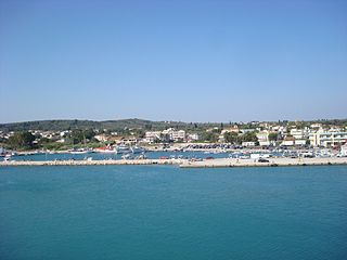
Kastro-Kyllini is a former municipality in Elis, West Greece, Greece. Since the 2011 local government reform it is part of the municipality Andravida-Kyllini, of which it is a municipal unit. The municipal unit has an area of 49.322 km2. The population was 3,622 in 2011. The municipality Kastro-Kyllini was created in 1999 as part of the Kapodistrias reform from the formerly independent communities Kyllini, Kato Panagia, Kastro and Neochori, that became municipal districts. After the 2011 Kallikratis reform, these municipal districts became (dependent) communities. Its seat of administration was the small port town of Kyllini.
Pastra is a village and a community in the southeastern part of the island of Kefalonia, Greece. It was the seat of the municipality of Eleios-Pronnoi. The community consists of the villages Pastra and Kremmydi. Pastra is 2 km northeast of Markopoulo, 3 km south of Agia Eirini, 5 km northwest of Skala, 6 km southwest of the port town of Poros and 25 km southeast of Argostoli.
Kallikomo is a village and a community in the municipal unit of Skillounta, Elis, Greece. It is situated 5 km from the Ionian Sea, 3 km west of Krestena, 5 km north of Kato Samiko and 16 km southeast of Pyrgos. The GR-9/E55 runs through the village. The junction with the Greek National Road 76 to Krestena and Megalopoli is 1 km east of the village. The community consists of the villages Kallikomo, Krounoi and Ladiko.
Varvasaina is a village and a community in the eastern part of the municipality of Pyrgos, Elis, Greece. The community consists of the villages Varvasaina and Kato Varvasaina. It is situated in a valley between low hills, 3 km southeast of Koliri, 3 km northwest of Salmoni, 5 km north of Epitalio and 5 km east of Pyrgos town centre. The Greek National Road 74 passes south of the village. The railway from Pyrgos to Kalamata and Olympia passes through Kato Varvasaina.

Agios Dimitrios is a town in Attica, Greece, and a suburb in the southern part of the Athens agglomeration.
Beloiannisz is a village in Fejér county, Hungary. It was founded by Communist Greek refugees who left Greece after the civil war, and was named after Nikos Beloyannis.
Pylaros is a former municipality on the island of Kefalonia, Ionian Islands, Greece. Since the 2019 local government reform it is part of the municipality Sami, of which it is a municipal unit. It is located in the north-central part of the island. It has a land area of 81.112 km² and a population of 1,422 inhabitants. The seat of the municipality and largest town is Agia Effimia.

Mesolouri is a mountain village and a former community in Grevena regional unit, Western Macedonia, Greece. Since the 2011 local government reform it is part of the municipality Grevena, of which it is a municipal unit. Mesolouri had 24 inhabitants as of 2021. The municipal unit has an area of 17.744 km2.

Shamlugh is a village in the Lori Province in northeastern Armenia. It is situated on the left bank of Debed River, at a road distance of 196 km north of the capital Yerevan and 63 km north of the provincial centre Vanadzor. The village had a majority Greek population; however, it is now predominantly populated by Armenians. According to the 2011 census, Shamlugh had 700 inhabitants, while the 2016 official estimate shows the current population is around 500.
Isaris is a village and a community in the municipality of Megalopoli, Arcadia, Greece. It is situated in the mountains west of the Alfeios valley, at about 750 m elevation. It is considered a traditional settlement. It is 2 km east of Vastas, 5 km northwest of Chranoi and 11 km southwest of Megalopoli. Its population in 2011 was 86 for the village, and 140 for the community, which includes the small villages Petrovouni and Chrousa.
Choremis is a village and a community of the municipality of Megalopoli, Arcadia, Greece. Since the 1970s it is situated on the left bank of the river Alfeios, which was rerouted for the lignite mines further east. It is 3 km northwest of Tripotamo, 4 km south of Thoknia and 5 km southwest of Megalopoli. The community consists of the villages Choremis and Apiditsa.
Platanos is a village and a community in the municipal unit of Akrata, Achaea, Greece. In 2011 Platanos had a population of 231 for the village, and 259 for the community, which includes the mountain villages Ano Potamia, Korinthiako Balkoni and Tsivlos. The village Platanos consists of two parts: the seaside settlement Paralia Platanou on the Gulf of Corinth and Platanos proper at about 250 m elevation on a mountain slope directly above Paralia Platanou. The villages Ano Potamia and Tsivlos are about 10 km south of Platanos. Platanos is 5 km west of Akrata and 18 km southeast of Aigio. The Greek National Road 8A and the railway Corinth - Patras pass north of Platanos.
Kamara is a mountain village and a community in the municipal unit of Falaisia, in the southwest of Arcadia, Greece. It is situated on a mountain slope, 5 km east of Tourkolekas, 6 km west of Longanikos, 7 km northwest of Dyrrachio and 18 km south of Megalopoli. In 2011 Kamara had a population of 163 for the village and 210 for the community, which includes the village Kampochori.
Akovos is a mountain village and a community in the municipal unit of Falaisia, southwestern Arcadia, Greece. It is situated in the foothills of the Taygetus mountains.
Pyli is a village and a community in Boeotia, Greece. The community includes the villages Lefka, Panakto and Prasino. It was the seat of the former municipality of Dervenochoria. The site of the ancient Attic fortress of Panactum is between the villages of Panakto and Prasino.
Skourochori is a village and a community in the municipality of Pyrgos, Elis, Greece. In 2011, it had a population of 610 for the village, and 782 for the community. It is situated near the Ionian Sea, at the foot of a low hill. It is 3 km south of Myrtia, 3 km east of Leventochori, 5 km northeast of Katakolo and 8 km west of Pyrgos town centre.
Mavranaioi is a village and a community of the Grevena municipality. Before the 2011 local government reform it was a part of the municipality of Theodoros Ziakas, of which it was a municipal district and the seat. The 2021 census recorded 223 residents in the community. The community of Mavranaioi covers an area of 37.934 km2.
Chrysovitsi is a mountain village and a community in the municipal unit of Falanthos, Arcadia, Greece. At the 2011 census its population was 33 for the village and 58 for the community, which includes the village Mantaiika, 5 km southeast of Chrysovitsi. Built on the slopes of Mainalo at 1,100 m, Chrysovitsi is one of the highest villages in the Peloponnese. It is a traditional settlement since November 23, 1998 and its code number is 12317201. Chrysovitsi is 4 km southwest of Piana, 7 km northeast of Lykochia, 11 km east of Stemnitsa and 15 km northwest of Tripoli.
Prasino is a village and a community in the municipal unit of Iardanos, Elis, Greece. It is 2 km northwest of Agios Georgios, 3 km southeast of Vounargo and 5 km northwest of Pyrgos town centre. The community consists of the villages Prasino, Glykorizo and Keramidia. Its elevation is 70 m.
