
The William Jolly Bridge is a heritage-listed road bridge over the Brisbane River between North Quay in the Brisbane CBD and Grey Street in South Brisbane, within City of Brisbane, Queensland, Australia. It was designed by A E Harding Frew and built from 1928 to 1932 by M R Hornibrook Ltd.

The Steel Bridge is a through truss, double-deck vertical-lift bridge across the Willamette River in Portland, Oregon, United States, opened in 1912. Its lower deck carries railroad and bicycle/pedestrian traffic, while the upper deck carries road traffic, and light rail (MAX), making the bridge one of the most multimodal in the world. It is the only double-deck bridge with independent lifts in the world and the second oldest vertical-lift bridge in North America, after the nearby Hawthorne Bridge. The bridge links the Rose Quarter and Lloyd District in the east to Old Town Chinatown neighborhood in the west.
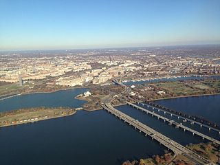
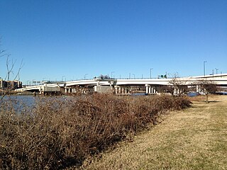
The 14th Street bridges are five bridges near each other that cross the Potomac River, connecting Arlington, Virginia and Washington, D.C. A major gateway for automotive and rail traffic, the bridge complex is named for 14th Street, which feeds automotive traffic into it on the D.C. end.

The Sellwood Bridge is a deck arch bridge that spans the Willamette River in Portland, Oregon, in the United States. The current bridge opened in 2016 and replaced a 1925 span that had carried the same name. The original bridge was Portland's first fixed-span bridge and, being the only river crossing for miles in each direction, the busiest two-lane bridge in Oregon. The Sellwood Bridge links the Sellwood and Westmoreland neighborhoods of Portland on the east side with Oregon Route 43/Macadam Avenue on the west side. At its east end it leads to Tacoma Street. The bridge is owned and operated by Multnomah County. The original span of 1925 was a steel truss bridge, while its 2016 replacement is a deck-arch-type bridge.
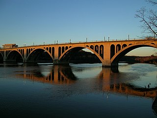
The Francis Scott Key Bridge, more commonly known as the Key Bridge, is a six-lane reinforced concrete arch bridge conveying U.S. Route 29 (US 29) traffic across the Potomac River between the Rosslyn neighborhood of Arlington County, Virginia, and the Georgetown neighborhood of Washington, D.C. Completed in 1923, it is Washington's oldest surviving road bridge across the Potomac River.
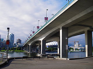
The Cambie Bridge is a six-lane symmetric, precast, varying-depth-post tension-box girder bridge spanning False Creek in Vancouver, British Columbia. The current bridge opened in 1985, but is the third bridge at the same location. Often referred to as the Cambie Street Bridge, it connects Cambie Street on the south shore of False Creek to both Nelson and Smithe Streets in the downtown peninsula. It is the easternmost of False Creek's fixed crossings; the Burrard and Granville bridges are a little more than a kilometre to the west, and the new Canada Line SkyTrain tunnel is built just west of the Cambie Bridge.
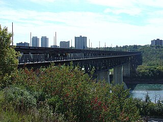
The High Level Bridge is a bridge that spans the North Saskatchewan River in Edmonton, Alberta, Canada. Located next to the Alberta Legislature Building, the bridge linked the separate communities of Edmonton and Strathcona, which became one city in 1912. It was designed from the outset to accommodate rail, streetcar, two-way automobile, and pedestrian traffic. The original bridge design included three tracks on the upper deck. The first CPR train operated on June 2, 1913, after which the bridge became a part of the Calgary-Edmonton main line. Streetcar service started on the west streetcar track of the bridge on August 11, 1913 with the east streetcar track opening by September of that year and automobile traffic after that. Automobile traffic did not begin at the same time as CPR and streetcar traffic as the lower deck had not been completed and the installation of galvanized iron under the tracks was still needed to prevent cinders dropping from steam trains onto traffic on the lower deck. Streetcars travelling northbound operated on the upstream side of the bridge, and southbound streetcars operated on the downstream side of the bridge; This left-hand operation was contrary to the right-hand driving on the lower traffic deck.
The 11th Street Bridges are a complex of three bridges across the Anacostia River in Washington, D.C., United States. The bridges convey Interstate 695 across the Anacostia to its southern terminus at Interstate 295 and DC 295. The bridges also connect the neighborhood of Anacostia with the rest of the city of Washington.

The George Rankin Jr. Memorial Bridge is a cantilever bridge that carries the Green Belt across the Monongahela River between Whitaker and Rankin in Pennsylvania in the USA. It carries four lanes of automobile traffic, plus pedestrian walkways, both paved with concrete. The bridge carries over 22,500 people per day. The bridge and many of its approach ramps were originally built with tram tracks, all of which have since been removed.
The Portland–Columbia Toll Bridge is a toll bridge that carries New Jersey Route 94 over the Delaware River, between Pennsylvania Route 611 at Portland, Pennsylvania and Columbia in Knowlton Township, New Jersey, United States. It is owned and operated by the Delaware River Joint Toll Bridge Commission. U.S. Route 46 merges with Interstate 80 located just north of the bridge on the New Jersey approach. All maps sign the bridge as U.S. Route 611 Alternate.

Fullers Bridge, officially called the Fullers Creek Bridge, a concrete beam bridge that spans the Lane Cove River, is located 9 km northwest of the central business district of Sydney in New South Wales, Australia. The bridge connects Delhi Road to Millwood Avenue, part of the A38 main road from Chatswood to North Ryde.

The Lamar Boulevard Bridge is a historic arch bridge carrying Texas State Highway Loop 343 over Lady Bird Lake in downtown Austin, Texas, United States. The bridge features six open-spandrel concrete arches spanning 659 feet (201 m) and carries tens of thousands of vehicles daily across the lake. Completed in 1942, the Lamar Boulevard Bridge was the second permanent bridge to cross the Colorado River, and one of the last Art Deco-style open-spandrel concrete arch bridges built in Texas. The bridge was named an Austin Landmark in 1993 and added to the National Register of Historic Places in 1994.

The Low Level Bridge is a bridge that spans the North Saskatchewan River in Edmonton, Alberta, Canada. Completed in 1900, this was the first bridge across the North Saskatchewan River. A railway track was added in 1902 to accommodate the Edmonton, Yukon and Pacific Railway.

The Intercity Viaduct is an automobile and pedestrian crossing of the Kansas River in the United States. Designed by Waddell and Hedrick, this four lane, two level deck truss bridge was built in 1907. It rises above the West Bottoms, and several sets of railroad tracks. It was the first roadway bridge to connect Kansas City, Missouri, with Kansas City, Kansas, non-stop all the way across. It is about 1.5 miles (2.4 km) long and carries eastbound traffic for Interstate 70 (I-70)/U.S. Route 24 (US 24)/US 40/US 169, while its sister bridge, the Lewis and Clark Viaduct, built in 1962, carries westbound traffic.

The U.S. 40 and 59 Bridges are twin multi-beam girder bridges over the Kansas River at Lawrence, Kansas. The west bridge carries two lanes of southbound traffic, connecting to Vermont Street, while the east bridge carries two lanes of northbound traffic from Massachusetts Street. Both bridges converge on the north end to become North 2nd Street. The east bridge is also the third bridge to be built at this location.
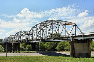
The Montopolis Bridge is a historic Parker through truss bridge in Austin, Texas. It is located in the Montopolis neighborhood where a bicycle and pedestrian walkway crosses the Colorado River in southeastern Travis County. The bridge consists of five 200-foot Parker through truss spans and four 52-foot steel I-beam approach spans resting on reinforced concrete abutments. It was added to the National Register of Historic Places on October 10, 1996.

The Fifth Street Viaduct or the Fifth Street Bridge, officially the Curtis Holt Sr. Bridge, is a bridge crossing Bacon's Quarter Branch in the Shockoe Valley of Richmond, Virginia in the United States. It carries automobile and pedestrian traffic between Downtown Richmond's Jackson Ward and Gilpin Court with the North Side's Chestnut Hill and Highland Park.
The Portland–Lewiston Interurban (PLI) was an electric railroad subsidiary of the Androscoggin Electric Company operating from 1914 to 1933 between Monument Square in Portland and Union Square in Lewiston, Maine. Hourly service was offered over the 40-mile (64 km) route between the two cities. Express trains stopping only at West Falmouth, Gray, New Gloucester, Upper Gloucester and Danville made the trip in 80 minutes, while trains making other local stops upon request required 20 minutes more. The line was considered the finest interurban railroad in the state of Maine.

The Manhattan Bridge Three Cent Line was a streetcar company that operated cars over the Manhattan Bridge between the boroughs of Brooklyn and Manhattan in New York City. As the name implied, the fare was only 3 cents per ride.

The State Street Bridge, also known as the Fort Road Bridge or the Bridgeport Bridge, is a bridge carrying State Street over the Cass River in Bridgeport, Michigan. It was listed on the National Register of Historic Places in 1995.


