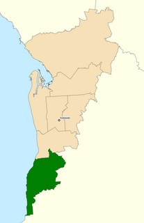
The Division of Hotham is an Australian Electoral Division in Victoria. It is located in the south-eastern suburbs of Melbourne. Hotham covers an area of approximately 83 square kilometres from Oakleigh in the north to Dingley Village in the south. The division includes the suburbs of Bentleigh East, Clarinda, Clayton, Clayton South, Coatesville, Huntingdale, Mulgrave, Notting Hill, Oakleigh, Oakleigh East, Oakleigh South, Waverley Park, Westall, and Wheelers Hill in their entirety; as well as parts of Bentleigh, Chadstone, Glen Waverley, Heatherton, McKinnon, Mount Waverley, Ormond, Springvale, Springvale South and Syndal.

The Division of Fenner is an Australian Electoral Division in the Australian Capital Territory and the Jervis Bay Territory. As of the 2018 redistribution, it includes Gungahlin and the part of Belconnen north of Belconnen Way and west of Eastern Valley Way, Aikman Drive and William Slim Drive. It also includes the Jervis Bay Territory.

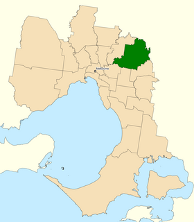
The Division of Swan is an Australian electoral division located in Western Australia.

The Division of Canberra is an Australian electoral division in the Australian Capital Territory. It is named for the city of Canberra, Australia's national capital, and includes all of central Canberra, Kowen, Majura, as well as part of Weston Creek, Woden Valley, Molonglo Valley, Belconnen, and Jerrabomberra. It is currently held by Alicia Payne of the Labor Party.

The Division of Bruce is an Australian Electoral Division in the state of Victoria. The division is located in the south-eastern suburbs of Melbourne. It covers an area of approximately 95 square kilometres (37 sq mi) including the suburbs of Dandenong North, Doveton, Endeavour Hills, Eumemmerring, Hallam, Lysterfield South, Noble Park and Noble Park North; and parts of Dandenong, Fountain Gate, Keysborough, Narre Warren, Narre Warren North, Springvale and Springvale South.

The Division of Barker is an Australian Electoral Division in the south-east of South Australia. The division was established on 2 October 1903, when South Australia's original single multi-member division was split into seven single-member divisions. It is named for Collet Barker, an early explorer of the region at the mouth of the Murray River. The 63,886 km² seat currently stretches from Morgan in the north to Port MacDonnell in the south, taking in the Murray Mallee, the Riverland, the Murraylands and most of the Barossa Valley, and includes the towns of Barmera, Berri, Bordertown, Coonawarra, Keith, Kingston SE, Loxton, Lucindale, Mannum, Millicent, Mount Gambier, Murray Bridge, Naracoorte, Penola, Renmark, Robe, Tailem Bend, Waikerie, and parts of Nuriootpa and Tanunda.

The Division of Boothby is an Australian electoral division in South Australia. The division was one of the seven established when the former Division of South Australia was redistributed on 2 October 1903 and is named after William Boothby (1829–1903), the Returning Officer for the first federal election.
The Division of Kingston is an Australian Electoral Division in South Australia covering the outer southern suburbs of Adelaide. The 171 km² seat stretches from Hallett Cove and O'Halloran Hill in the north to Sellicks Beach in the south, including the suburbs of Aldinga Beach, Christie Downs, Christies Beach, Hackham, Hallett Cove, Huntfield Heights, Lonsdale, Maslin Beach, Moana, Morphett Vale, Old Noarlunga, Onkaparinga Hills, Port Noarlunga, Reynella, Seaford, Sellicks Beach, Sheidow Park, Port Willunga, Trott Park, Woodcroft, and parts of Happy Valley and McLaren Flat.
The Division of Angas was an Australian Electoral Division in South Australia. The division was created in 1903 and abolished in 1934. It was named for George Fife Angas, a South Australian pioneer, and was based in various rural areas to the east, south-east, north-east and north-west of Adelaide at different times including Angaston, Cadell, Eudunda, Gawler, Kapunda, Nuriootpa, Mallala, Murray Bridge, Tanunda and Walker Flat and from 1922 stretched further eastward as far as the South Australian border. It was a generally marginal seat which was won at various times by the Australian Labor Party and the Nationalist Party.

The Division of Holt is an Australian Electoral Division in Victoria. It is located in the outer south-eastern suburbs of Melbourne, including Blind Bight, Botanic Ridge, Cannons Creek, Clyde, Cranbourne, Devon Meadows, Hampton Park, Junction Village, Lynbrook, and Warneet; and parts of Clyde North, Lyndhurst, Narre Warren South, Pearcedale and Tooradin.
The Division of Jagajaga is an Australian Electoral Division in the state of Victoria. It is located in the north-eastern suburbs of Melbourne, and lies north of the Yarra River. It covers an area of approximately 104 square kilometres and comprises the suburbs of Bellfield, Briar Hill, Diamond Creek, Eaglemont, Greensborough, Heidelberg, Heidelberg Heights, Heidelberg West, Ivanhoe, Ivanhoe East, Lower Plenty, Montmorency, Plenty, Rosanna, St Helena, Viewbank, Yallambie, Watsonia and Watsonia North; and parts of Bundoora, Bundoora, Eltham, Eltham North, Hurstbridge, Macleod, Wattle Glen and Yarrambat.
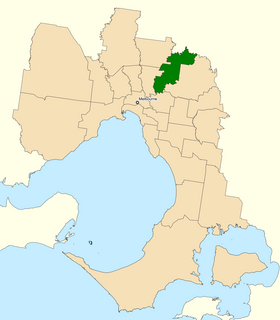
The Division of Menzies is an Australian Electoral Division in the state of Victoria. It is located in the north-eastern suburbs of Melbourne. It is bordered by Koonung Creek to the south, and until redistribution in 2018 was also bordered by the Yarra River to the north. It covers the suburbs of Bulleen, Croydon Hills, Doncaster, Doncaster East, Donvale, Park Orchards, Templestowe, Templestowe Lower, Warrandyte and Warrandyte South. Additionally, parts of Ringwood North, Warranwood, Wonga Park and Eltham fall under the Division.

The Division of Mallee is an Australian Electoral Division in the state of Victoria. It is located in the far north-west of the state, adjoining the border with South Australia in the west, and the Murray River in the north. At 81,962 square kilometres (31,646 sq mi), it is the largest Division in Victoria. It includes the centres of Mildura, Ouyen, Swan Hill, St Arnaud, Warracknabeal, Stawell and Horsham.

The Division of Shortland is an Australian electoral division in the state of New South Wales. The division is named after Lt John Shortland, an early explorer of the Hunter Region, and was proclaimed at the redistribution of 11 May 1949, and was first contested at the 1949 federal election.

The Division of Wakefield was an Australian electoral division in the state of South Australia. The seat was a hybrid rural-urban electorate that stretched from Salisbury in the outer northern suburbs of Adelaide at the south of the seat right through to the Clare Valley at the north of the seat, 135 km from Adelaide. It included the suburbs of Elizabeth, Craigmore, Munno Para, and part of Salisbury, and the towns of Balaklava, Clare, Freeling, Gawler, Kapunda, Mallala, Riverton, Tarlee, Virginia, Williamstown, and part of Port Wakefield.
Imanpa Community is in the Northern Territory of Australia. It is seven km north of the Lasseter Highway, the main road running between the Stuart Highway and Uluru. Imanpa lies 160 km east of Uluru and 200 km south west of Alice Springs. It is seventeen kilometres from Mount Ebenezer Roadhouse which is owned and run by the community, along with Angas Downs Station / Indigenous Protected Area.
Angas was an electoral district of the House of Assembly in the Australian state of South Australia from 1938 to 1970 and which was associated with the town of Angaston.
Barossa was an electoral district of the House of Assembly in the colony of South Australia from 1857 to 1938 and again from 1956 to 1970. Barossa was also the name of an electoral district of the unicameral South Australian Legislative Council from 1851 until its abolition in 1857, George Fife Angas being the member.

The Division of Fraser was an Australian Electoral Division in the Australian Capital Territory and the Jervis Bay Territory. The division was created in a redistribution of the former Division of Australian Capital Territory, gazetted on 19 April 1974. It was named for Jim Fraser, who was the Member for Australian Capital Territory from 1951 to 1970. It encompassed the northern suburbs of Canberra, including the districts of Belconnen, Gungahlin, North Canberra and also the Jervis Bay Territory. It also generally included the land in the ACT north of the Molonglo River and Lake Burley Griffin, although at one time it included some suburbs in the inner south and immediately prior to its abolition it had lost Reid and Campbell to the division of Canberra. It was always a safe seat for the Australian Labor Party.

The District Council of Ridley-Truro was a local government area in South Australia from 1991 to 1997.