Dobovica

Last updated
Dobovica
Sv. Katarina v Dobovici.jpg
Slovenia location map.svg
Red pog.svg
Dobovica
Location in Slovenia
Coordinates: 46°2′45.47″N15°2′44.19″E / 46.0459639°N 15.0456083°E / 46.0459639; 15.0456083 Coordinates: 46°2′45.47″N15°2′44.19″E / 46.0459639°N 15.0456083°E / 46.0459639; 15.0456083
Country Flag of Slovenia.svg Slovenia
Traditional region Lower Carniola
Statistical region Central Sava
Municipality Litija
Area
  Total 2.53 km2 (0.98 sq mi)
Elevation 706.9 m (2,319.2 ft)
Population (2002)
  Total 43
[1]

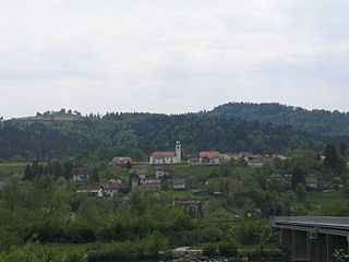
Dobovica (pronounced  [dɔbɔˈʋiːtsa] ) is a settlement in the Municipality of Litija in central Slovenia. Traditionally the area was part of Lower Carniola and is now included with the rest of the municipality in the Central Sava Statistical Region. [2]

Municipality An administrative division having corporate status and usually some powers of self-government or jurisdiction

A municipality is usually a single administrative division having corporate status and powers of self-government or jurisdiction as granted by national and regional laws to which it is subordinate. It is to be distinguished (usually) from the county, which may encompass rural territory or numerous small communities such as towns, villages and hamlets.

Litija Town in Upper Carniola, Slovenia

Litija is a town in the Litija Basin in central Slovenia. It is located in the valley of the Sava River, east of the capital Ljubljana, in the traditional region of Upper Carniola. The entire municipality is now included in the Central Sava Statistical Region; until January 2014 it was part of the Central Slovenia Statistical Region. The town is home to about 6,500 people.

Slovenia republic in Central Europe

Slovenia, officially the Republic of Slovenia, is a sovereign state located in southern Central Europe at a crossroads of important European cultural and trade routes. It is bordered by Italy to the west, Austria to the north, Hungary to the northeast, Croatia to the southeast, and the Adriatic Sea to the southwest. It covers 20,273 square kilometers (7,827 sq mi) and has a population of 2.07 million. One of the successor states of the former Yugoslavia, Slovenia is a parliamentary republic and a member of the United Nations, of the European Union, and of NATO. The capital and largest city is Ljubljana.

The local church, built on a small hill south of the main settlement, is dedicated to Saint Catherine and belongs to the Parish of Dole pri Litiji. It is a Baroque building dating to the early 18th century when a nave, a belfry, and a new sanctuary were added to a 17th-century chapel that is now preserved as a side chapel. [3]

Church (building) building constructed for Christian worship

A church building or church house, often simply called a church, is a building used for Christian religious activities, particularly for Christian worship services. The term is often used by Christians to refer to the physical buildings where they worship, but it is sometimes used to refer to buildings of other religions. In traditional Christian architecture, the church is often arranged in the shape of a Christian cross. When viewed from plan view the longest part of a cross is represented by the aisle and the junction of the cross is located at the altar area.

Catherine of Alexandria Egyptian missionary, saint depicted with a wheel

Saint Catherine of Alexandria, or Saint Katharine of Alexandria, also known as Saint Catherine of the Wheel and The Great Martyr Saint Catherine, is, according to tradition, a Christian saint and virgin, who was martyred in the early 4th century at the hands of the pagan emperor Maxentius. According to her hagiography, she was both a princess and a noted scholar, who became a Christian around the age of 14, converted hundreds of people to Christianity, and was martyred around the age of 18. More than 1,100 years following her martyrdom, Saint Joan of Arc identified Catherine as one of the Saints who appeared to her and counselled her.

A parish is a territorial entity in many Christian denominations, constituting a division within a diocese. A parish is under the pastoral care and clerical jurisdiction of a parish priest, who might be assisted by one or more curates, and who operates from a parish church. Historically, a parish often covered the same geographical area as a manor. Its association with the parish church remains paramount.

Related Research Articles

Berinjek in Styria, Slovenia

Berinjek is a small settlement in the Municipality of Litija in central Slovenia. Traditionally the area was part of Styria and is now included with the rest of the municipality in the Central Sava Statistical Region; until January 2014 the municipality was part of the Central Slovenia Statistical Region.

Breg pri Litiji Place in Lower Carniola, Slovenia

Breg pri Litiji is a settlement on the right bank of the Sava River in the Municipality of Litija in central Slovenia. Traditionally the area was part of Lower Carniola and is now included with the rest of the municipality in the Central Sava Statistical Region; until January 2014 the municipality was part of the Central Slovenia Statistical Region.

Čateška Gora in Lower Carniola, Slovenia

Čateška Gora is a settlement in the Municipality of Litija in central Slovenia. Traditionally the area was part of Lower Carniola and is now included with the rest of the municipality in the Central Sava Statistical Region; until January 2014 the municipality was part of the Central Slovenia Statistical Region.

Gabrska Gora, Litija in Lower Carniola, Slovenia

Gabrska Gora is a settlement south of Gabrovka in the Municipality of Litija in central Slovenia. Traditionally the area was part of Lower Carniola and is now included with the rest of the municipality in the Central Sava Statistical Region; until January 2014 the municipality was part of the Central Slovenia Statistical Region. It includes the hamlets of Gora, Stari Boršt, Gabrje, and Turn.

Gorenje Jelenje in Lower Carniola, Slovenia

Gorenje Jelenje is a settlement northwest of Dole in the Municipality of Litija in central Slovenia. Traditionally the area was part of Lower Carniola and is now included with the rest of the municipality in the Central Sava Statistical Region; until January 2014 the municipality was part of the Central Slovenia Statistical Region.

Javorje pri Gabrovki in Lower Carniola, Slovenia

Javorje pri Gabrovki is a settlement northwest of Gabrovka in the Municipality of Litija in central Slovenia. Traditionally the area was part of Lower Carniola and is now included with the rest of the municipality in the Central Sava Statistical Region; until January 2014 the municipality was part of the Central Slovenia Statistical Region.

Kresnice Place in Lower Carniola, Slovenia

Kresnice is a settlement on the right bank of the Sava River in the Municipality of Litija in central Slovenia. Traditionally the area was part of Lower Carniola and it is now included with the rest of the municipality in the Central Sava Statistical Region; until January 2014 the municipality was part of the Central Slovenia Statistical Region.

Kresniške Poljane in Lower Carniola, Slovenia

Kresniške Poljane is a settlement on the right bank of the Sava River in the Municipality of Litija in central Slovenia. It lies between Jevnica and Kresnice. The railway line from Ljubljana to Zidani Most runs through the settlement. Traditionally the area was part of Lower Carniola and it is now included with the rest of the municipality in the Central Sava Statistical Region; until January 2014 the municipality was part of the Central Slovenia Statistical Region.

Laze pri Gobniku in Lower Carniola, Slovenia

Laze pri Gobniku is a settlement west of Gabrovka in the Municipality of Litija in central Slovenia. Traditionally the area was part of Lower Carniola and is now included with the rest of the municipality in the Central Sava Statistical Region.

Mamolj Place in Lower Carniola, Slovenia

Mamolj is a settlement in the hills east of Litija in central Slovenia. Traditionally the area was part of Lower Carniola and is now included with the rest of the Municipality of Litija in the Central Sava Statistical Region. It includes the hamlets of Spodnji Mamolj, Zgornji Mamolj, Čebelnik, Češek, Podmilj, Resnarica, and Trinkavs.

Podpeč pod Skalo in Lower Carniola, Slovenia

Podpeč pod Skalo is a small settlement northwest of Gabrovka in the Municipality of Litija in central Slovenia. Traditionally the area was part of Lower Carniola and is now included with the rest of the municipality in the Central Sava Statistical Region.

Podšentjur in Lower Carniola, Slovenia

Podšentjur is a settlement on the right bank of the Sava River in the Municipality of Litija in central Slovenia. Traditionally the area was part of Lower Carniola and is now included with the rest of the municipality in the Central Sava Statistical Region.

Ponoviče Place in Styria, Slovenia

Ponoviče is a settlement along the left bank of the Sava River in the Municipality of Litija in central Slovenia. The railway line from Ljubljana to Zidani Most runs through the settlement. Traditionally the area was part of Styria and is now included with the rest of the municipality in the Central Sava Statistical Region. The settlement includes the hamlets of Mačkovina and Smrekarica.

Potok pri Vačah in Styria, Slovenia

Potok pri Vačah is a small settlement east of Vače in the Municipality of Litija in central Slovenia. Traditionally, the area was part of Styria and is now included with the rest of the municipality in the Central Sava Statistical Region.

Prelesje, Litija in Lower Carniola, Slovenia

Prelesje is a small settlement east of Dole in the Municipality of Litija in central Slovenia. Traditionally the area was part of Lower Carniola and is now included with the rest of the municipality in the Central Sava Statistical Region.

Ravne, Litija in Lower Carniola, Slovenia

Ravne is a small settlement in the hills above the right bank of the Sava River northwest of Gabrovka in the Municipality of Litija in central Slovenia. Traditionally the area was part of Lower Carniola and is now included with the rest of the municipality in the Central Sava Statistical Region.

Slivna in Styria, Slovenia

Slivna is a settlement west of Vače the Municipality of Litija in central Slovenia. The area was traditionally part of Styria and is now included with the rest of the municipality in the Central Sava Statistical Region. The settlement is the Geometric Centre of the Republic of Slovenia.

Stranski Vrh in Lower Carniola, Slovenia

Stranski Vrh is a settlement in the Municipality of Litija in central Slovenia. Traditionally the area was part of Lower Carniola and is now included with the rest of the municipality in the Central Sava Statistical Region.

Vernek Place in Styria, Slovenia

Vernek is a settlement on the left bank of the Sava River in the Municipality of Litija in central Slovenia. Traditionally the area was part of Styria and is now included with the rest of the municipality in the Central Sava Statistical Region.

Zgornji Log in Styria, Slovenia

Zgornji Log is a settlement on the left bank of the Sava River in the Municipality of Litija in central Slovenia. The railway line from Ljubljana to Zidani Most runs through the settlement and crosses the Sava just north of the settlement core. Traditionally the area was part of Styria and is now included with the rest of the municipality in the Central Sava Statistical Region.

References