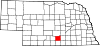
Kearney County is a county located in the U.S. state of Nebraska. As of the 2020 United States Census, the population was 6,688. Its county seat is Minden. The county was formed in 1860. It was named for Fort Kearny, which in turn was named for Brigade General Stephen W. Kearny.

Buffalo County is a county located in the U.S. state of Nebraska in the Midwestern United States. As of the 2020 United States Census, the population was 50,084, making it Nebraska's fifth-most populous county. Its county seat is Kearney. The county was created in 1855 and was organized in 1870. It was named after the once-prevalent bison herds of the Great Plains.

Kearney is the county seat of Buffalo County, Nebraska, United States. The population was 33,790 in the 2020 census, making it the 5th most populous city in Nebraska. It is home to the University of Nebraska at Kearney. The westward push of the railroad as the Civil War ended gave new birth to the community.
Nebraska City is a city in Nebraska and the county seat of Otoe County, Nebraska, United States. As of the 2020 census, the city population was 7,222.
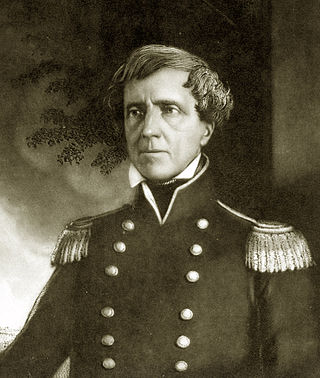
Stephen Watts Kearny was one of the foremost antebellum frontier officers of the United States Army. He is remembered for his significant contributions in the Mexican–American War, especially the conquest of California. The Kearny code, proclaimed on September 22, 1846, in Santa Fe, established the law and government of the newly acquired territory of New Mexico and was named after him. His nephew was Major General Philip Kearny of American Civil War fame.

The Territory of Nebraska was an organized incorporated territory of the United States that existed from May 30, 1854, until March 1, 1867, when the final extent of the territory was admitted to the Union as the state of Nebraska. The Nebraska Territory was created by the Kansas–Nebraska Act of 1854. The territorial capital was Omaha. The territory encompassed areas of what is today Nebraska, Wyoming, South Dakota, North Dakota, Colorado, and Montana.

The Mormon Trail is the 1,300-mile (2,100 km) long route from Illinois to Utah on which Mormon pioneers traveled from 1846–47. Today, the Mormon Trail is a part of the United States National Trails System, known as the Mormon Pioneer National Historic Trail.

The Shawnee are a Native American people of the Northeastern Woodlands. Their language, Shawnee, is an Algonquian language.

Fort Kearny was a historic outpost of the United States Army founded in 1848 in the western U.S. during the middle and late 19th century. The fort was named after Col. and later General Stephen Watts Kearny. The outpost was located along the Oregon Trail near Kearney, Nebraska. The town of Kearney took its name from the fort. The "e" was added to Kearny by postmen who consistently misspelled the town name. A portion of the original site is preserved as Fort Kearny State Historical Park by the Nebraska Game and Parks Commission.

Fort Phil Kearny was an outpost of the United States Army that existed in the late 1860s in present-day northeastern Wyoming along the Bozeman Trail. Construction began in 1866 on Friday, July 13, by Companies A, C, E, and H of the 2nd Battalion, 18th Infantry, under the direction of the regimental commander and Mountain District commander Colonel Henry B. Carrington.
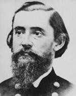
Henry Beebee Carrington was a lawyer, professor, prolific author, and an officer in the United States Army during the American Civil War and in the Old West during Red Cloud's War. A noted engineer, he constructed a series of forts to protect the Bozeman Trail, but suffered a major defeat at the hands of the warchief Red Cloud.

Bent's Old Fort is a fort located in Otero County in southeastern Colorado, United States. A company owned by Charles Bent and William Bent and Ceran St. Vrain built the fort in 1833 to trade with Southern Cheyenne and Arapaho Plains Indians and trappers for buffalo robes. For much of its 16-year history, the fort was the only major white American permanent settlement on the Santa Fe Trail between Missouri and the Mexican settlements. It was destroyed in 1849.

Buda is an unincorporated community in Buffalo County, Nebraska, United States. First established as Kearney Station after the Union Pacific reached the area August 1, 1866 supplying freight and mail for Fort Kearny five miles south across the Platte River. It was renamed Shelby in 1876 and then Buda in 1878 after Buda the former capital of the Kingdom of Hungary.

The following is an alphabetical list of articles related to the U.S. State of Nebraska.

Fort Griffin, now a Texas state historic site as Fort Griffin State Historic Site, was a US Cavalry fort established 31 July 1867 by four companies of the Sixth Cavalry, U.S. Army under the command of Lt. Col. S. D. Sturgis, in the western part of North Texas, specifically northwestern Shackelford County, to give settlers protection from early Comanche and Kiowa raids. Originally called Camp Wilson after Henry Hamilton Wilson, a recently deceased lieutenant and son of Republican senator and later vice president, Henry Wilson, it was later named for Charles Griffin, a former Civil War Union general who had commanded, as de facto military governor, the Department of Texas during the early years of Reconstruction.
Fort Lisa (1812–1823) was established in 1812 in what is now North Omaha in Omaha, Nebraska by famed fur trader Manuel Lisa and the Missouri Fur Company, which was based in Saint Louis. The fort was associated with several firsts in Nebraska history: Lisa was the first European farmer in Nebraska; it was the first settlement by American citizens set up in the then-recent Louisiana Purchase; Lisa's wife was the first woman resident of European descent in Nebraska; and the first steamboat to navigate Nebraska waters, the Western Engineer, arrived at Fort Lisa in September 1819.

Fort Omaha, originally known as Sherman Barracks and then Omaha Barracks, is an Indian War-era United States Army supply installation. Located at 5730 North 30th Street, with the entrance at North 30th and Fort Streets in modern-day North Omaha, Nebraska, the facility is primarily occupied by the Metropolitan Community College. A Navy Operational Support Center and Marine Corps Reserve unit, along with an Army Reserve unit occupy the periphery of the 82.5 acres (33.4 ha) fort. The government deeded all but four parcels of the land to the Metropolitan Community College in 1974.

The Great Platte River Road was a major overland travel corridor approximately following the course of the Platte River in present-day Nebraska and Wyoming that was shared by several popular emigrant trails during the 19th century, including the Trapper's Trail, the Oregon Trail, the Mormon Trail, the California Trail, the Pony Express route, and the military road connecting Fort Leavenworth and Fort Laramie. The road, which extended nearly 370 miles (600 km) from the Second Fort Kearny to Fort Laramie, was utilized primarily from 1841 to 1866. In modern times it is often regarded as a sort of superhighway of its era, and has been referred to as "the grand corridor of America's westward expansion".
Sherman most commonly refers to: