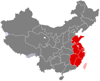
East China is a geographical and a loosely defined cultural region that covers the eastern coastal area of China.
Southwest China is a region in the south of the People's Republic of China.
South Central China or South-Central China is a region of the People's Republic of China defined by State Council that includes the provinces of Guangdong, Hainan, Henan, Hubei and Hunan, as well as the Guangxi Zhuang Autonomous Region; in addition, the two provincial-level special administrative regions (SARs), Hong Kong and Macau, are also included under South Central China.

Dragsum Tsho (Tibetan: བྲག་གསུམ་མཚོ་, Wylie: brag gsum mtsho, THL: Draksum Tso, Pagsum Co, literally meaning “three rocks” in Tibetan, is a lake covering 28 square kilometres in Gongbo'gyamda County, Nyingchi of the Tibet Autonomous Region, China, approximately 300 km east of Lhasa. At 3,700 metres over sea level it is about 18 km long and has an average width of approximately 1.5 km. The deepest point of the green lake measures 120 metres. The lake is also known as Gongga Lake.
Baima is a town in Baxoi County, Chamdo Prefecture of the Tibet Autonomous Region of the People's Republic of China. It lies at an altitude of 3,772 metres (12,378 ft). As of 2020, it administers Baima Residential Community and the following eight villages:

Western China is the west of China. In the definition of the Chinese government, Western China covers one municipality (Chongqing), six provinces, and three autonomous regions.

Gertse County, Gêrzê County or Gaize County is a county located in Ngari Prefecture in the northwest of the Tibet Autonomous Region, bordering Xinjiang to the north.
Gar Chongsar or Gar Xincun, Gar New Village, is a village in Gar County, Ngari Prefecture, Tibet Autonomous Region, China. It is the site of the Ngari Gunsa Airport.
Sogmai, or Suomai is a village in Günsa Township, Gar County, Tibet Autonomous Region, China. It is the site of the Ngari Gunsa Airport.

Central China is a geographical and a loosely defined cultural region that includes the provinces of Henan, Hubei and Hunan. Jiangxi is sometimes also regarded to be part of this region. Central China is now officially part of South Central China governed by the People's Republic of China. In the context of the Rise of Central China Plan by the State Council of the People's Republic of China in 2004, surrounding provinces including Shanxi, Anhui, are also defined as regions of Central China development zones.

Gushi is a county of 1,023,857 people directly governed by Henan, People's Republic of China. It is administered by the prefecture-level city of Xinyang.
Binyang County is a county of Guangxi Zhuang Autonomous Region, China, it is under the administration of the prefecture-level city of Nanning, the capital of Guangxi, with a permanent population of 782,255 and a hukou population of 1,051,373 as of the 2010 Census. It borders the prefecture-level cities of Laibin to the northeast and Guigang to the east. The main highways passing near the county seat are China National Highways 322 and 324. The local economy is based mostly on industry and services. The county seat is Binzhou Town, known as one of the oldest towns in Guangxi which has population over 200,000 people. People speak Binyanghua in Binyang, which is a branch of Cantonese.
Xixiangtang District is one of 7 districts of the prefecture-level city of Nanning, the capital of Guangxi Zhuang Autonomous Region, South China. The district was approved to establish by merging the former two districts of Yongxin and Chengbei (城北区) by the Chinese State Council on September 15, 2004.
Jiangnan District is one of seven districts of the prefecture-level city of Nanning, the capital of Guangxi Zhuang Autonomous Region, South China.

Chengzhong District is one of four districts of Liuzhou, Guangxi Zhuang Autonomous Region, China.

Yufeng District is one of four districts of Liuzhou, Guangxi Zhuang Autonomous Region, China.

Liubei District is the county seat and one of four districts of Liuzhou, Guangxi Zhuang Autonomous Region, China.

Liunan District is one of four districts of Liuzhou, Guangxi Zhuang Autonomous Region, China.
Rong'an County is under the administration of Liuzhou, Guangxi Zhuang Autonomous Region, China. It borders the prefecture-level city of Guilin to the east.

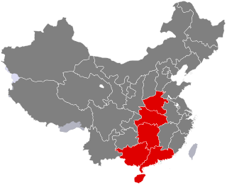
South China is a geographical and cultural region that covers the southernmost part of China. Its precise meaning varies with context. A notable feature of South China in comparison to the rest of China is that most of its citizens are not native speakers of Standard Chinese. Cantonese is the most common language in the region while the Guangxi region contains the largest concentration of China's ethnic minorities, each with their own language.

