
Tuolumne Meadows is a gentle, dome-studded, sub-alpine meadow area along the Tuolumne River in the eastern section of Yosemite National Park in the United States. Its approximate location is 37°52.5′N119°21′W. Its approximate elevation is 8,619 feet (2,627 m). The term Tuolumne Meadows is also often used to describe a large portion of the Yosemite high country around the meadows, especially in context of rock climbing.

Lembert Dome is a granite dome rock formation in Yosemite National Park in the US state of California. The dome soars 800 feet (240 m) above Tuolumne Meadows and the Tuolumne River and can be hiked starting at the Tioga Road in the heart of Tuolumne Meadows, 8 miles (13 km) west of the Tioga Pass Entrance to Yosemite National Park. The landform is an example of a rôche moutonnée with clear lee and stoss slopes.

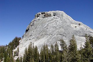
Pothole Dome is a granite dome on the west side of Tuolumne Meadows, in Yosemite National Park located at Tioga Road mile marker 18. Near Pothole Dome is Marmot Dome. The summit of the dome is easily accessible by foot from a parking area on the Tioga Road at mile marker 18. The view from the summit includes most of Tuolumne Meadows and in the distance, Cathedral Peak. The dome gives evidence of many of the geologic processes at work in Yosemite during and after the last ice age. In particular, the stranded, rounded boulders from a glacier that has long since retreated, and the water-eroded "potholes" provide evidence of two ways that water can interact with granite.

Fairview Dome is a prominent granite dome in Yosemite National Park, located 1.8 miles (2.9 km) north of Cathedral Peak and 4 miles (6.4 km) west of Tuolumne Meadows. Near Fairview Dome is Marmot Dome, linked by an area called Razor Back. Northwest is Hammer Dome.

The North Face of Fairview Dome also known as the Regular Route of Fairview Dome is a technical rock climbing route in Tuolumne Meadows of Yosemite National Park. It is featured in Fifty Classic Climbs of North America.
Pywiack Dome is a prominent 600 foot granite dome in Yosemite National Park, located 0.7 miles (1.1 km) north-east of Tenaya Lake, 4 miles (6.4 km) west of Tuolumne Meadows and 200 feet (61.0 m) from the Tioga Road. It is quite near Harlequin Dome, and North and South Whizz Domes are north.

Daff Dome or DAFF Dome is a prominent 800 feet (243.8 m) granite dome in Yosemite National Park, 3 miles (4.8 km) west of Tuolumne Meadows and 1,700 feet (0.5 km) from the Tioga Road. It is southeast of Doda Dome, and is near both West Cottage Dome and East Cottage Dome; it is also near Lamb Dome. Since the dome was never officially named, the DAFF Dome name was adopted in the 1960s as an acronym of "Dome Across From Fairview" Dome.
Hiking, rock climbing, and mountain climbing around Tuolumne Meadows in Yosemite National Park has many options.
Dozier Dome is a granite dome, in the Tuolumne Meadows region of Yosemite National Park. It is named after Jeff Dozier.
Mariolumne Dome is a granite dome, in the Tuolumne Meadows region of Yosemite National Park.

Puppy Dome is a granite dome in Tuolumne Meadows, Yosemite National Park, California.

Unicorn Peak is a peak, in Tuolumne Meadows, Yosemite National Park. Unicorn Peak is due east of Cathedral Peak, and the north summit is highest.
Dog Dome is a granite dome in the Tuolumne Meadows area of Yosemite National Park. Dog Dome is quite near Lembert Dome, which is just northeast. Dog Dome is also near to Dog Lake.
Drug Dome is a granite dome in the Tuolumne Meadows area of Yosemite National Park. Drug Dome is just west of Fairview Dome. It is also near Mariolumne Dome, Lamb Dome and Medlicott Dome.
West Cottage Dome is a granite dome in the Tuolumne Meadows area of Yosemite National Park. West Cottage Dome is rarely visited, though it the closest dome to Daff Dome.
East Cottage Dome, also, Erratic Dome, is a granite dome in the Tuolumne Meadows area of Yosemite National Park.
Hammer Dome, is a granite dome in the Tuolumne Meadows area of Yosemite National Park. Hammer Dome is a bit north, of Cathedral Creek, which has its source, near Cathedral Peak. Hammer Dome is loosely northwest of Fairview Dome, is north of both Medlicott Dome and Pywiack Dome, all three of which are south of California State Route 120, which runs through Tuolumne Meadows to Tioga Pass. North and South Whizz Domes are close.
North Whizz Dome is a granite dome in the Tuolumne Meadows area of Yosemite National Park. North Whizz Dome is a bit south, of Cathedral Creek, which has its source, near Cathedral Peak. North Whizz Dome Dome is north of both Medlicott Dome and Pywiack Dome, both of which are south of California State Route 120, which runs through Tuolumne Meadows to Tioga Pass. It is near Hammer Dome, also, Daff Dome and Polly Dome are nearby.
South Whizz Dome is a granite dome in the Tuolumne Meadows area of Yosemite National Park. South Whizz Dome is a bit south, of Cathedral Creek, which has its source, near Cathedral Peak. South Whizz Dome Dome is north of both Medlicott Dome and Pywiack Dome, both of which are south of California State Route 120, which runs through Tuolumne Meadows to Tioga Pass. It is near Hammer Dome, also, Daff Dome and Polly Dome are nearby.
Lamb Dome Dome is a granite dome, in the Tuolumne Meadows area of Yosemite National Park. It is one of the smaller domes.

