Doi Phi Pan Nam

Last updated
Doi Phi Pan Nam
Laos location map Topographic.png
Red triangle with thick white border.svg
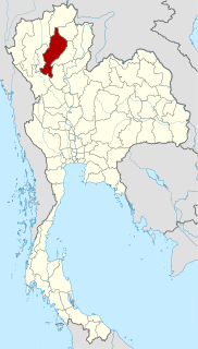
Doi Phi Pan Nam
Location on the Lao–Thai border
Highest point
Elevation 1,745 m (5,725 ft)
Listing List of mountains in Thailand
Coordinates 19°07′33″N101°15′22″E / 19.12583°N 101.25611°E / 19.12583; 101.25611 Coordinates: 19°07′33″N101°15′22″E / 19.12583°N 101.25611°E / 19.12583; 101.25611 [1]
Geography
Location LaoThai border
Parent range Luang Prabang Range
Climbing
First ascent unknown
Easiest route hike

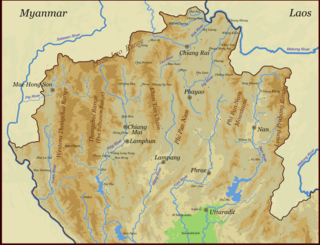
Doi Phi Pan Nam, Thai : ดอยผีปันน้ำ, is a 1,745 m high mountain in Southeast Asia, part of the Luang Prabang Range (ทิวเขาหลวงพระบาง). [2]

Thai language language spoken in Thailand

Thai, Central Thai or Ayutthaya or Siamese, is the sole official and national language of Thailand and the first language of the Central Thai people and vast majority of Thai of Chinese origin. It is a member of the Tai group of the Kra–Dai language family. Over half of Thai vocabulary is derived from or borrowed from Pali, Sanskrit, Mon and Old Khmer. It is a tonal and analytic language, similar to Chinese and Vietnamese.

Southeast Asia Subregion of Asia

Southeast Asia or Southeastern Asia is a subregion of Asia, consisting of the countries that are geographically south of China and Japan, east of India, west of Papua New Guinea, and north of Australia. Southeast Asia is bordered to the north by East Asia, to the west by South Asia and the Bay of Bengal, to the east by Oceania and the Pacific Ocean, and to the south by Australia and the Indian Ocean. The region is the only part of Asia that lies partly within the Southern Hemisphere, although the majority of it is in the Northern Hemisphere. In contemporary definition, Southeast Asia consists of two geographic regions:

  1. Mainland Southeast Asia, also known historically as Indochina, comprising parts of Northeast India, Vietnam, Laos, Cambodia, Thailand, Myanmar, and West Malaysia.
  2. Maritime Southeast Asia, also known historically as Nusantara, the East Indies and Malay Archipelago, comprises the Andaman and Nicobar Islands of India, Indonesia, East Malaysia, Singapore, Philippines, East Timor, Brunei, Christmas Island, and the Cocos (Keeling) Islands. Taiwan is also included in this grouping by many anthropologists.
Luang Prabang Range mountain range in Laos and Thailand

The Luang Prabang Range, named after Luang Prabang, is a mountain range straddling northwestern Laos and Northern Thailand. Most of the range is located in Sainyabuli Province (Laos), as well as Nan and Uttaradit Provinces (Thailand), with small parts in Phitsanulok and Loei Provinces. Several rivers such as the Nan, Pua and Wa river, have their source in this range. Phu Fa waterfall, the biggest and the tallest waterfall in Nan Province, is also located in these mountains. This range is part of the Luang Prabang montane rain forests ecoregion.

Contents

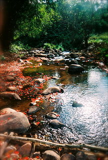
It is located at the eastern end of the Thai highlands, on the international border between Laos and Thailand. The Wa River has its source beneath this mountain. [3]

Thai highlands Natural region in Thailand

The Thai highlands or Hills of northern Thailand is a mountainous natural region in the north of Thailand. Its mountain ranges are part of the system of hills extending through Laos, Burma, and China and linking to the Himalayas, of which they may be considered foothills.

Laos Socialist state in southeast Asia

Laos, officially the Lao People's Democratic Republic, commonly referred to by its colloquial name of Muang Lao, is a socialist state and the only landlocked country in Southeast Asia. Located at the heart of the Indochinese peninsula, Laos is bordered by Myanmar (Burma) and China to the northwest, Vietnam to the east, Cambodia to the southwest, and Thailand to the west and southwest.

Thailand Constitutional monarchy in Southeast Asia

Thailand, officially the Kingdom of Thailand and formerly known as Siam, is a country at the center of the Southeast Asian Indochinese peninsula composed of 76 provinces. At 513,120 km2 (198,120 sq mi) and over 68 million people, Thailand is the world's 50th largest country by total area and the 21st-most-populous country. The capital and largest city is Bangkok, a special administrative area. Thailand is bordered to the north by Myanmar and Laos, to the east by Laos and Cambodia, to the south by the Gulf of Thailand and Malaysia, and to the west by the Andaman Sea and the southern extremity of Myanmar. Its maritime boundaries include Vietnam in the Gulf of Thailand to the southeast, and Indonesia and India on the Andaman Sea to the southwest. Although nominally a constitutional monarchy and parliamentary democracy, the most recent coup in 2014 established a de facto military dictatorship.

See also

Khun Nan National Park

Khun Nan National Park is a protected area in the western side of the Luang Prabang Range in the Thai/Lao border area, on the Thai side of the ridge. It is named after Khun Nan subdistrict (tambon) of Chaloem Phra Kiat District of Nan Province and includes parts located in Bo Kluea District. The park is located north of the Doi Phu Kha National Park and was established in 2009.

Related Research Articles

Lampang Province Province in Thailand

Lampang is one of the northern provinces (changwat) of Thailand. The old name of Lampang was Khelang Nakhon.

Phayao Province Province in Thailand

Phayao is one of the northern provinces (changwat) of Thailand. Neighboring provinces are Nan, Phrae, Lampang, and Chiang Rai. In the northeast it borders Xaignabouli of Laos.

Northern Thailand Region in Chiang Mai

Northern Thailand is geographically characterised by several mountain ranges, which continue from the Shan Hills in bordering Myanmar to Laos, and the river valleys which cut through them. Though like most of Thailand, it has a tropical savanna climate, its relatively high elevation and latitude contribute to more pronounced seasonal temperature variation, with cooler winters than the other regions. Historically it is related to the Lanna Kingdom and its culture.

Doi Nang Non mountain range of the Thai highlands located in Chiang Rai Province, Thailand

Doi Nang Non is a mountain range in the Thai highlands in Chiang Rai Province, Thailand. It is a karstic formation with numerous waterfalls and caves rising at the southern end of the Daen Lao Range. Part of its area is managed as the Tham Luang–Khun Nam Nang Non Forest Park.

Doi Phu Kha National Park national park of Thailand

Doi Phu Kha National Park covers a part of 8 districts in the Luang Prabang Range, Nan Province, Northern Thailand and has rich natural resources. It is Northern Thailand's largest National park and rivers such as Nan River and Pua River, have their sources within the area of the range under the protection of the park limits. Khun Nan National Park is located north of the park area.

Khlong Lan National Park

Khlong Lan National Park is a 420 km2 (160 sq mi) national park in Thailand.

Mae Charim National Park

Mae Charim National Park, also known as Mae Jarim, is a protected area in the Luang Prabang Range, Nan Province, Northern Thailand. The Wa River, a popular river for white water rafting between July and December, flows through the park area. The park was established in 1961. Mae Charim National Park is part of the Luang Prabang montane rain forests ecoregion.

Khun Tan Range

The Khun Tan Range is a mountain range that occupies a central position in Northern Thailand. Most of the range is located in Chiang Mai, western Chiang Rai, Lampang and Lamphun Provinces.

Doi Luang, meaning 'Large Mountain', may refer to:

Phi Pan Nam Range mountain range in Thailand and Laos

The Phi Pan Nam Range, also Pee Pan Nam, is a 400 km (249 mi) long system of mountain ranges in the eastern half of the Thai highlands. It is mostly in Thailand, although a small section in the northeast is within Sainyabuli and Bokeo Provinces, Laos.

Khun Chae National Park National park in Chiang Rai Province, Thailand

Khun Chae National Park is a national park in Chiang Rai Province, Thailand. This rugged park is home to high mountains and waterfalls.

Lam Nam Nan National Park

Lam Nam Nan National Park is a national park in Thailand's Phrae and Uttaradit provinces. The park is home to rugged mountains and the reservoir of the Sirikit Dam.

Khun Tan railway station is a railway station on the Northern Line located in Lamphun Province, Thailand. It is operated by the State Railway of Thailand, and is 683.14 km (424.5 mi) from Bangkok railway station. Khun Tan Railway Station is in the Tha Pladuk Subdistrict, Mae Tha District.

Khun Phawo National Park

Khun Phawo National Park is a national park in the Mae Ramat District, Tak Province, Thailand.

Khun Khan National Park national park of Thiland

Khun Khan National Park is a national park in Thailand's Chiang Mai Province. This mountainous park is home to forests, waterfalls and cliff-top viewpoints.

Si Nan National Park

Si Nan National Park is a national park in Thailand's Nan Province. This mountainous park is home to steep cliffs and a long section of the Nan River.

References

  1. Google Earth
  2. ดร.กระมล ทองธรรมชาติ และคณะ, สังคมศึกษา ศาสนาและวัฒนธรรม ม.1, สำนักพิมพ์ อักษรเจริญทัศน์ อจท. จำกัด, 2548, หน้า 24-25
  3. Khun Nan National Park - Trekthailand