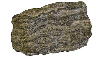
Gneiss is a common and widely distributed type of metamorphic rock. It is formed by high-temperature and high-pressure metamorphic processes acting on formations composed of igneous or sedimentary rocks. This rock is formed under pressures ranging from 2 to 15 kbar, sometimes even more, and temperatures over 300 °C (572 °F). Gneiss nearly always shows a banded texture characterized by alternating darker and lighter colored bands and without a distinct cleavage.

Half Dome is a quartz monzonite batholith at the eastern end of Yosemite Valley in Yosemite National Park, California. It is a well-known rock formation in the park, named for its distinct shape. One side is a sheer face while the other three sides are smooth and round, making it appear like a dome cut in half. It stands at nearly 8,800 feet above sea level and is composed of quartz monzonite, an igneous rock that solidified several thousand feet within the Earth. At its core are the remains of a magma chamber that cooled slowly and crystallized beneath the Earth's surface. The solidified magma chamber was then exposed and cut in half by erosion, therefore leading to the geographic name Half Dome.
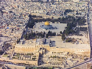
The Temple Mount, also known as The Noble Sanctuary, al-Aqsa Mosque compound, or simply al-Aqsa, and sometimes as Jerusalem's holyesplanade, is a hill in the Old City of Jerusalem that has been venerated as a holy site for thousands of years, including in Judaism, Christianity and Islam.
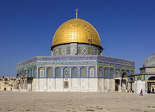
The Dome of the Rock is an Islamic shrine at the center of the Al-Aqsa mosque compound on the Temple Mount in the Old City of Jerusalem. It is the world's oldest surviving work of Islamic architecture, the earliest archaeologically attested religious structure to be built by a Muslim ruler and its inscriptions contain the earliest epigraphic proclamations of Islam and of the Islamic prophet Muhammad.

The Aqsa Mosque, also known as the Qibli Mosque or Qibli Chapel, is the main congregational mosque or prayer hall in the Al-Aqsa mosque compound in the Old City of Jerusalem. In some sources the building is also named al-Masjid al-Aqṣā, but this name primarily applies to the whole compound in which the building sits, which is itself also known as "Al-Aqsa Mosque". The wider compound is known as Al-Aqsa or Al-Aqsa mosque compound, also known as al-Ḥaram al-Sharīf.

Tuolumne Meadows is a gentle, dome-studded, sub-alpine meadow area along the Tuolumne River in the eastern section of Yosemite National Park in the United States. Its approximate location is 37°52.5′N119°21′W. Its approximate elevation is 8,619 feet (2,627 m). The term Tuolumne Meadows is also often used to describe a large portion of the Yosemite high country around the meadows, especially in context of rock climbing.

A salt dome is a type of structural dome formed when salt intrudes into overlying rocks in a process known as diapirism. Salt domes can have unique surface and subsurface structures, and they can be discovered using techniques such as seismic reflection. They are important in petroleum geology as they can function as petroleum traps.

The RCA Dome was a domed stadium in Indianapolis. It was the home of the Indianapolis Colts NFL franchise for 24 seasons (1984–2007).

Lembert Dome is a granite dome rock formation in Yosemite National Park in the US state of California. The dome soars 800 feet (240 m) above Tuolumne Meadows and the Tuolumne River and can be hiked starting at the Tioga Road in the heart of Tuolumne Meadows, 8 miles (13 km) west of the Tioga Pass Entrance to Yosemite National Park. The landform is an example of a rôche moutonnée with clear lee and stoss slopes.

The Vredefort impact structure is the largest verified impact structure on Earth. The crater, which has since been eroded away, has been estimated at 170–300 kilometres (110–190 mi) across when it was formed. The remaining structure, comprising the deformed underlying bedrock, is located in present-day Free State province of South Africa. It is named after the town of Vredefort, which is near its centre. The structure's central uplift is known as the Vredefort Dome. The impact structure was formed during the Paleoproterozoic Era, 2.023 billion years ago. It is the second-oldest known impact structure on Earth, after Yarrabubba.

In structural geology, an anticline is a type of fold that is an arch-like shape and has its oldest beds at its core, whereas a syncline is the inverse of an anticline. A typical anticline is convex up in which the hinge or crest is the location where the curvature is greatest, and the limbs are the sides of the fold that dip away from the hinge. Anticlines can be recognized and differentiated from antiforms by a sequence of rock layers that become progressively older toward the center of the fold. Therefore, if age relationships between various rock strata are unknown, the term antiform should be used.

The Regular Northwest Face of Half Dome was the first Grade VI big wall climbing route in the United States. It was first climbed in 1957 by a team consisting of Royal Robbins, Mike Sherrick, and Jerry Gallwas. Its current aid climbing rating is VI 5.9 A1 or 5.12 for the free climbing variation. It is recognized in the historic climbing text Fifty Classic Climbs of North America and considered a classic around the world.
Malcolm Dome was an English music journalist.
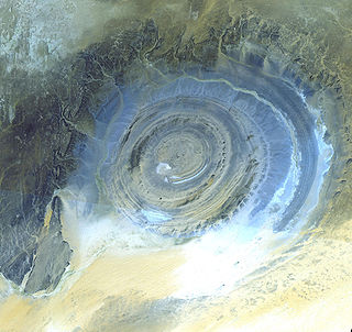
A dome is a feature in structural geology where a circular part of the Earth's surface has been pushed upward, tilting the pre-existing layers of earth away from the center. In technical terms, it consists of symmetrical anticlines that intersect each other at their respective apices. Intact, domes are distinct, rounded, spherical-to-ellipsoidal-shaped protrusions on the Earth's surface. A slice parallel to Earth's surface of a dome features concentric rings of strata. If the top of a dome has been eroded flat, the resulting structure in plan view appears as a bullseye, with the youngest rock layers at the outside, and each ring growing progressively older moving inwards. These strata would have been horizontal at the time of deposition, then later deformed by the uplift associated with dome formation.

The Foundation Stone, or the Noble Rock is the rock at the center of the Dome of the Rock in Jerusalem. It is also known as the Pierced Stone, because it has a small hole on the southeastern corner that enters a cavern beneath the rock, known as the Well of Souls.
The Dome Rock Mountains are a mountain range in southern La Paz County, Arizona. The range borders the Colorado River on the west and the Colorado River Indian Reservation on the northwest located in the Lower Colorado River Valley. Quartzsite, Arizona lies on the eastern foothills of the range.

Dome of the Chain is an Islamic free-standing domed building located adjacently east of the Dome of the Rock in the al-Aqsa Mosque compound in the Old City of Jerusalem. It is one of many small buildings that can be found scattered around the Al Aqsa Mosque. Its exact historical use and significance are under scholarly debate. Erected in 691–92 CE, the Dome of the Chain is one of the oldest surviving structures at the al-Aqsa Mosque compound.

The Templum Domini was the name attributed by the Crusaders to the Dome of the Rock in Jerusalem. It became an important symbol of Jerusalem, depicted on coins minted under the Catholic Christian Kingdom of Jerusalem.

Tomichi Dome rises north of U.S. Highway 50 west of Hot Springs Creek and south of Waunita Hot Springs Reservoir in the southeast quarter of Gunnison County, Colorado. It is situated within the Gunnison National Forest.
St. Peter's Dome is a granite-topped peak on Pikes Peak massif in the Pike National Forest. The peak, at 9,528 feet (2,904 m) in elevation, is located in El Paso County, Colorado, above Colorado Springs. It is located about 8 miles (13 km) from Colorado Springs along Old Stage and Gold Camp Roads. Old Stage Road is picked up behind The Broadmoor and Gold Camp Road winds through Cheyenne Canyon.

