The first written records in the history of Dominica began in November 1493, when Christopher Columbus spotted the island. Prior to European contact, Dominica was inhabited by the Arawak. Dominica was a French colony from 1715 until the end of the Seven Years' War in 1763, and then became a British colony from 1763 to 1978. It became an independent nation in 1978.
Telecommunications in Dominica comprises telephone, radio, television and internet services. The primary regulatory authority is the National Telecommunication Regulatory Commission which regulates all related industries to comply with The Telecommunications Act 8 of 2000.

The music of Dominica includes a variety of genres including all the popular genres of the world. Popular music is widespread, with a number of native Dominican performers gaining national fame in imported genres such as calypso, reggae, soca, kompa, zouk and rock and roll. Dominica's own popular music industry has created a form called bouyon, which combines elements from several styles and has achieved a wide fanbase in Dominica. Groups include WCK, Native musicians in various forms, such as reggae, kadans (Ophelia Marie, and calypso, have also become stars at home and abroad.
The Leeward Islands are a group of islands situated where the northeastern Caribbean Sea meets the western Atlantic Ocean. Starting with the Virgin Islands east of Puerto Rico, they extend southeast to Guadeloupe and its dependencies. In English, the term Leeward Islands refers to the northern islands of the Lesser Antilles chain. The more southerly part of this chain, starting with Dominica, is called the Windward Islands. Dominica was originally considered a part of the Leeward Islands, but was transferred from the British Leeward Islands to the British Windward Islands in 1940.

The French West Indies or French Antilles are the parts of France located in the Antilles islands of the Caribbean:
Antillean Creole is a French-based creole that is primarily spoken in the Lesser Antilles. Its grammar and vocabulary include elements of French, Carib, English, and African languages.

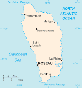
Morne Diablotins is the highest mountain in Dominica, an island-nation in the Caribbean Lesser Antilles. It is the second highest mountain in the Lesser Antilles, after La Grande Soufrière in Guadeloupe. Morne Diablotins is located in the northern interior of the island, about 24 kilometres (15 mi) north of Dominica's capital Roseau and about 10 kilometres (6.2 mi) southeast of Portsmouth, the island's second-largest town. It is located within Morne Diablotin National Park.
The culture of Dominica is formed by the inhabitants of the Commonwealth of Dominica. Dominica is home to a wide range of people. Although it was historically occupied by several native tribes, it was the Taíno and Island Caribs (Kalinago) tribes that remained by the time European settlers reached the island. "Massacre" is a name of a river dedicated to the murders of the native villagers by both French and British settlers, because the river "ran red with blood for days." Each claimed the island and imported slaves from Africa. The remaining Caribs now live on a 3,700-acre (15 km2) Carib Territory on the east coast of the island. They elect their own chief.

The Îles des Saintes, also known as Les Saintes, is a group of small islands in the archipelago of Guadeloupe, an overseas department of France. It is part of the Canton of Trois-Rivières and is divided into two communes: Terre-de-Haut and Terre-de-Bas. It is in the arrondissement of Basse-Terre and also in Guadeloupe's 4th constituency.

Dominica, officially the Commonwealth of Dominica, is an island country in the Caribbean. The capital, Roseau, is located on the western side of the island. It is geographically situated as part of the Windward Islands chain in the Lesser Antilles archipelago in the Caribbean Sea. Dominica's closest neighbours are two constituent territories of the European Union, the overseas departments of France, Guadeloupe to the northwest and Martinique to the south-southeast. Dominica comprises a land area of 750 km2 (290 sq mi), and the highest point is Morne Diablotins, at 1,447 m (4,747 ft) in elevation. The population was 71,293 at the 2011 census.
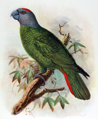
The Martinique amazon is a hypothetical extinct species of Caribbean parrot in the family Psittacidae. It is not known from any material remains, but was said to be similar to the red-necked amazon from Dominica, the next major island to the north of Martinique. Natives are known to have traded extensively in parrots between the Antilles, and it seems that the Martinique population was in some way related to or even descended from A. arausiaca.

Air Guadeloupe was a small French international airline with its head office in Les Abymes, Guadeloupe, France. At one time, it was on the property of Le Raizet Airport. Later it was located in the Immeuble Le Caducet.

Articles related to the French overseas department of Guadeloupe include:
The 2007 Martinique earthquake took place on November 29 2007 at in the Windward Islands region, underneath the Martinique Passage. It was a magnitude 7.4 earthquake that occurred 18 km (11 mi) west northwest from Basse-Pointe, Martinique.
The Dominica–France Maritime Delimitation Agreement is a 1987 treaty between Dominica and France which delimits the maritime boundary between Dominica and the French islands of Guadeloupe and Martinique. It was the first maritime boundary treaty in the Central America/Caribbean region to be based on the rules of the Convention on the Law of the Sea.
The Dominican blind snake or Dominican worm snake is a species of blind snake that is endemic to the Caribbean island-nation of Dominica, in the Lesser Antilles.
Kurlson Benjamin is a Dominican footballer who currently plays for Dominican side Bath Estate and the Dominica national football team.

Guadeloupe Women's National Football Team is the national team of Guadeloupe. They have only played in very few matches.

The Commonwealth of Dominica and the Republic of France maintain historical, political, economic, social and cultural relations. Sometimes referred to as "French Dominique", Dominica also shares close ties with its nearest neighbours, the overseas departments of the French Republic, Guadeloupe to the north and Martinique to the south. At present, Dominica is connected to the French islands by an inter-island express ferry. Under the auspice of the European Union both Dominica and France are tied economically via a 2008 concluded multilateral Economic Partnership Agreement (EPA) trade-deal representing many Caribbean nations under the name CARIFORUM. They are further members of: The Association of Caribbean States (ACS), the Caribbean Postal Union, the Organisation internationale de la Francophonie, the International Monetary Fund (IMF), the World Bank, and the United Nations.

