Dongqiao, Tibet

Last updated
Dongqiao
Village
China Tibet location map.svg
Red pog.svg
Dongqiao
Location within Tibet
Coordinates: 31°50′56.2″N90°35′6.3″E / 31.848944°N 90.585083°E / 31.848944; 90.585083 Coordinates: 31°50′56.2″N90°35′6.3″E / 31.848944°N 90.585083°E / 31.848944; 90.585083
Country People's Republic of China
Region Tibet
Prefecture Nagqu Prefecture
County Amdo County
Population
   Major Nationalities Tibetan
   Regional dialect Tibetan language
Time zone +8

Dongqiao (Chinese :东巧) is a village in Amdo County of Nagqu Prefecture, Tibet Autonomous Region, People's Republic of China. The village of Dongqiao is noted for its hot spring, Jipu. Dongqiao geologically gives its name to the wider Dongqiao-Nagqu Subregion and the Banggong-Dongqiao-Nujiang fault zone.

Chinese language family of languages

Chinese is a group of related, but in many cases not mutually intelligible, language varieties, forming the Sinitic branch of the Sino-Tibetan language family. Chinese is spoken by the Han majority and many minority ethnic groups in China. About 1.2 billion people speak some form of Chinese as their first language.

Amdo County County in Tibet, Peoples Republic of China

Amdo County is a county within Nagqu of the Tibet Autonomous Region of China. The county covers an area of 43,410.85 square kilometres and is dominated by mainly Tibetan grassland. In 2000 it had a population of 32,843.

Tibet Autonomous Region Autonomous region

The Tibet Autonomous Region (TAR) or Xizang Autonomous Region, called Tibet or Xizang for short, is a province-level autonomous region in southwest China. It was formally established in 1965 to replace the Tibet Area, an administrative division the People's Republic of China (PRC) took over from the Republic of China (ROC), about five years after the dismissal of the Kashag by the PRC following the 1959 Tibetan uprising, and about 13 years after Tibet's incorporation into the PRC in 1951.

Contents

Geography and geology

Dongqiao is located about 90 kilometres (56 mi) west of Amdo Town. [1] It is located several kilometres to the south of Qiangma and Zigetangcuo Lake, to the northeast of Dongqiacuo lake at an altitude of about 4,657 metres (15,279 ft). [2] [3] The Nu River, also known as the Nujiang River flows nearby forming a valley and the Nutiang River also flows nearby. [4] [5] [6] A small valley is located 7 kilometres (4.3 mi) southeast of Dongqiao. [7] Dongqiao village gives its name to a large region which it is located in which is known geologically for its ophiolite, termed the "Dongqiao ophiolite belt", which is dated to the late Jurassic to early Cretaceous age. [8] [9] [10] The Jurassic age formations form three distinct geological regions to the north of Lhasa, from north to south the Dongqiao-Nagqu Subregion, the Doilungdeqen-Lhunzhub Subregion and the Sangri Subregion. [11] The northern boundary is known as the Banggong-Dongqiao-Nujiang fault zone or Bangongcuo-Dingqing fault zone, which divides it from the Qiangtang Terrane to the north beyond this. [12] [11] Towards the end of the Jurassic period, the ophiolite became covered by chromitite. [4] As Guangcen Li puts it in a 1990 paper, "the ophiolites appear to be covered in turn by a transgressive marine detrital Upper Jurassic to lower most Cretaceous series." [13]

Amdo Town Town in Tibet, China

Amdo, also Anduo, and Draknak, is a town and seat of Amdo County in the Nagqu Prefecture of the northern Tibet Autonomous Region of China. It lies 464 kilometres north of Lhasa and 138 km north of Nagqu.

"Constructed on the southern side of the Dangla Mountains, Amdo is a Chinese-style town on the Qinghai-Tibet Highway. The road here leads off to the west, heading towards the Mt. Kailash area via the Changthang Plateau. Many of the buses from Golmud to Lhasa used to stay overnight here."

Qiangma Town in Tibet, China

Qiangma, also Qangma or Qiangmazhen is a small town and township-level division of Amdo County in the Nagqu Prefecture of the Tibet Autonomous Region, in China. It is located just south of Zi Getangcuo Lake, 90.7 kilometres (56.4 mi) southwest of Amdo Town. It covers an area of 5,467 square kilometres (2,111 sq mi) and as of 2004 it had a population of about 1700. The principal economic activity is animal husbandry, pastoral yak, goat, sheep, and so on.

Zigetangcuo Lake

Zigetangcuo Lake is a crenogenic meromictic lake in the North Tibetan Plateau. It is located in Nagqu Prefecture, north of Dongqiao. It has an area of 18,700 ha at an altitude of 4560 meters. It is the meromictic lake with the highest known altitude.

The Chinese Academy of Geological Sciences has conducted studies in the area, identifying "diamond orebodies of diamondiferous ultrabasic rock type in Dongqiao and Lhobsa of Amdo County, northern Tibet." [1] The village of Dongqiao is noted for its hot spring, Jipu. [14]

The Chinese Academy of Geological Sciences is an institution that engages in geoscience research in the People's Republic of China. The academy was established in 1956 and reorganized in 1999. Administratively it is under the PRC Ministry of Land and Resources.

Economy

Due to its geological background, Dongqiao is also a known mining spot, containing the Dongfeng Chrome Mine. [15]

Related Research Articles

Qinghai Province

Qinghai, is a province of the People's Republic of China located in the northwest of the country. As one of the largest province-level administrative divisions of China by area, the province is ranked fourth-largest in area, and has the third-smallest population.

Qinghai Lake largest lake in China

Qinghai Lake, Koko Nor or Tso Ngonpo is the largest lake in China. Located in Qinghai province on an endorheic basin, Qinghai Lake is classified as a saline and alkaline lake. Qinghai Lake has a surface area of 4,317 square kilometres (1,667 sq mi); an average depth of 21 metres (69 ft), and a maximum depth of 25.5 m (84 ft) as measured in 2008. The current Chinese name "Qinghai," the older Mongolian name "Kokonor", and the Tibetan name translate to "Green Sea", "Blue Lake" and "Teal Sea", respectively. Qinghai Lake is located about 100 kilometres (62 mi) west of the provincial capital of Xining at 3,205 m (10,515 ft) above sea level in a hollow of the Tibetan plateau. Twenty-three rivers and streams empty into Qinghai Lake, most of them seasonal. Five permanent streams provide 80% of total influx.

Khams Tibetan is the Tibetic language used by the majority of the people in Kham, which is now divided between the eastern part of Tibet Autonomous Region, the southern part of Qinghai, the western part of Sichuan, and the northwestern part of Yunnan, China. It is one of the six main spoken Tibetic languages, the other five being Central Tibetan language, Amdo, Ladakhi, Dzongkha and Balti. These Tibetic languages share the same written script, but their pronunciations, vocabularies and grammars are different. These differences may have emerged due to geographical isolation of the regions of Tibet. Khams Tibetan is used alongside Standard Tibetan and Amdo Tibetan in broadcasting. Khams Tibetan is not mutually intelligible with other Tibetic languages.

Golog Tibetan Autonomous Prefecture Autonomous prefectures in Qinghai, Peoples Republic of China

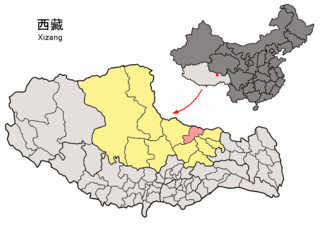
GologTibetan Autonomous Prefecture is an autonomous prefecture occupying the southeastern corner of Qinghai province, People's Republic of China. The prefecture has an area of 76,312 km2 (29,464 sq mi) and its seat is located in Maqên County.

Salar is a Turkic language spoken by the Salar people, who mainly live in the provinces of Qinghai and Gansu in China; some also live in Ili, Xinjiang. It is an eastern outlier of the Oghuz branch of Turkic, the other Oghuz languages being spoken mostly in West-Central Asia. The Salar number about 105,000 people, about 70,000 (2002) speak the Salar language; under 20,000 monolinguals.

Geladaindong Peak mountain in Peoples Republic of China

Geladaindong Peak is a snow-covered mountain located in southwestern Qinghai province of China near the border of Tibet Autonomous Region. It is the tallest mountain in the Tanggula Mountain Range of the Tibetan Plateau with an elevation of 6,621 metres (21,722 ft) above sea level. The traditional source of the Yangtze River, begins with glaciers on its surface. The Yangtze's true source, however, lies 325 km (202 mi) away at the head of the Dam Qu.

Nagqu Town Town in Tibet Autonomous Region, Peoples Republic of China

Nagqu Town, Nagchu in original Tibetan or Naqu, also known as Nagchuka or Nagquka, is a town in northern Tibet, seat of Nagqu, approximately 328 km (204 mi) by road north-east of the capital Lhasa, within the People's Republic of China.

Seni District District in Tibet Autonomous Region, Peoples Republic of China

Seni District is a district within the Nagqu of the Tibet Autonomous Region, western People's Republic of China.

Nyainrong County County in Tibet, Peoples Republic of China

Nyainrong County is a small county under the administration of the prefecture-level city of Nagqu, in the north of the Tibet Autonomous Region, bordering Qinghai province to the north. Yurla is a favourite of the people of the county.

The Amdolese language is the Tibetic language spoken by the majority of Amdolese, mainly in Qinghai and some parts of Sichuan and Gansu.

Golok rebellions (1917–1949)

The Ngolok rebellions (1917–1949) were a series of military campaigns against unconquered Ngolok (Golok) tribal Tibetan areas of Qinghai (Amdo), undertaken by two Hui commanders, Gen. Ma Qi and Gen. Ma Bufang, on behalf of the Beiyang and Kuomintang governments of the Republic of China. The campaigns lasted between 1917 and 1949.

P. Matthias Hermanns was a missionary of the SVD and a German Tibetologist.

Bangong suture

The Bangong suture zone is approximately 1200 km long and trends in an east–west orientation, and a key location in the central Tibet conjugate fault zone. Located in central Tibet between the Lhasa and Qiangtang terranes, it is a discontinuous belt of ophiolites and mélange that is 10–20 km wide, up to 50 km wide in places. The northern part of the fault zone consists of northeast striking sinistral strike-slip faults while the southern part consists of northwest striking right lateral strike-slip faults. These conjugate faults to the north and south of the Bangong intersect with each other along the Bangong-Nujiang suture zone.

Cona Lake lake of China

Cona, also Dongaii Cona or Tsonag Lake, is a major lake of northern Tibet Autonomous Region, China and is It is located in Amdo County, west of the road between Nagqu Town and Amdo Town. The lake is considered holy to the Tibetans especially in the Bon religion, as it is seen as the "soul lake" of the Razheng Living Buddha. The smaller Ganong Lake lies almost adjacent to the southeast.

Pana, Tibet Town in Tibet, China

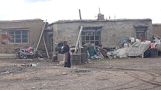
Pana, also Pagnag is a small town and township-level division of Amdo County in the Nagqu Prefecture of the Tibet Autonomous Region, in China. It is located just outside Amdo Town. As of 2004 it had a population of about 2700, 683 of which were living in the town of Pana. The principal economic activity is animal husbandry, pastoral yak, goat, sheep, and so on. Blueschist outcrops are found in the area. The villagers in recent times organized a railway protecting committee to select locals to monitor the Qinghai-Tibet Railway.

Yanshiping, Tibet Town in Tibet, Peoples Republic of China

Yanshiping, also Yan Shi is a small town physically situated in the southwest of Qinghai province, China. However, it is under the jurisdiction of Amdo County in the Nagqu Prefecture of the Tibet Autonomous Region. At an elevation of 4,720 metres (15,490 ft), it is one of the highest year-round settlements in the world. The principal economic activity is animal husbandry.

High pressure metamorphic terranes along the Bangong-Nujiang Suture Zone

High pressure terranes along the ~1200 km long east-west trending Bangong-Nujiang suture zone (BNS) on the Tibetan Plateau have been extensively mapped and studied. Understanding the geodynamic processes in which these terranes are created is key to understanding the development and subsequent deformation of the BNS and Eurasian deformation as a whole.

Chen Qingying, is a Chinese tibetologist. He is the director of the History Research Institute under the China Tibetology Research Center.

References

  1. 1 2 Liu, Nailong (1996). Mineral deposits of China. Geological Pub. House. p. 159. ISBN   978-7-116-02076-4 . Retrieved 22 July 2012.
  2. "Maps". Google, Inc. Retrieved 21 July 2012.
  3. "Dongqiao". GeoNames . Retrieved 22 July 2012.
  4. 1 2 European Space Agency; IEEE Geoscience and Remote Sensing Society (2003). IGARSS. ESA Scientific & Technical Publications Branch. p. 2596. Retrieved 22 July 2012.
  5. Universität zu Köln. Geologisches Institut (1994). Sonderveröffentlichungen des Geologischen Instituts der Universität Köln. Universität Köln. Retrieved 22 July 2012.
  6. Abstracts: 30th International Geological Congress, Beijing, China, 4-14 August 1996. The Congress. 1996. p. 304. Retrieved 22 July 2012.
  7. Chengfa Chang; Royal Society (Great Britain); Zhongguo ke xue yuan (1988). The geological evolution of Tibet: report of the 1985 Royal Society-Academia Sinica Geotraverse of the Qinghai-Xizang Plateau. Royal Society. p. 93. ISBN   978-0-85403-362-1 . Retrieved 22 July 2012.
  8. Sharma, Kaushal Kishore (1991). Geology and geodynamic evolution of the Himalayan collision zone. Pergamon Press. p. 212. Retrieved 22 July 2012.
  9. Zhang, Shouxin (18 September 2009). Geological Formation Names of China (1866-2000). Springer. p. 251. ISBN   978-3-540-93823-1 . Retrieved 22 July 2012.
  10. Burtman, Valentin Semenovich; Molnar, Peter Hale (1993). Geological and Geophysical Evidence for Deep Subduction of Continental Crust Beneath the Pamir. Geological Society of America. p. 10. ISBN   978-0-8137-2281-8 . Retrieved 22 July 2012.
  11. 1 2 Chengfa Chang; Royal Society (Great Britain); Zhongguo ke xue yuan (1988). The geological evolution of Tibet: report of the 1985 Royal Society-Academia Sinica Geotraverse of the Qinghai-Xizang Plateau. Royal Society. p. 34. ISBN   978-0-85403-362-1 . Retrieved 22 July 2012.
  12. Wiley, Thomas J.; Howell, D. G.; Wong, Florence L. (1990). Terrane analysis of China and the Pacific Rim. Circum-Pacific Council for Energy and Mineral Resources. p. 239. ISBN   978-0-933687-14-1 . Retrieved 22 July 2012.
  13. Li, Guangcen (1990). Geology of the Himalayas: Papers on geology. Geological Publishing House. p. 104. ISBN   978-7-116-00748-2 . Retrieved 22 July 2012.
  14. Zheng, Mianping (1997). An Introduction to Saline Lakes on the Qinghai-Tibet Plateau. Springer. p. 110. ISBN   978-0-7923-4098-0 . Retrieved 22 July 2012.
  15. China. 冶金工业部 (1994). Zhongguo gang tie gong ye nian jian. Ye jin gong ye chu ban she. Retrieved 22 July 2012.