
The Herzegovina-Neretva Canton is one of 10 cantons of the Federation of Bosnia and Herzegovina in Bosnia and Herzegovina.

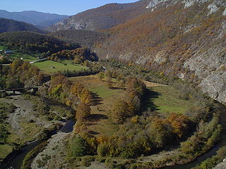
The Neretva, also known as Narenta, is one of the largest rivers of the eastern part of the Adriatic basin. Four HE power-plants with large dams provide flood protection, power and water storage. It is recognized for its natural environment and diversity of its landscape.

Gradačac is a city located in the Tuzla Canton of the Federation of Bosnia and Herzegovina, an entity of Bosnia and Herzegovina. It is situated in the northeastern part of Bosnia and Herzegovina, roughly 40 km (25 mi) south of the Sava river. As of 2013, it has a population of 41,836 inhabitants. The city is well known for its castle.

Lukavac is a town and municipality located in Tuzla Canton of the Federation of Bosnia and Herzegovina, an entity of Bosnia and Herzegovina. According to the 2013 census, the town has a population of 12,061 inhabitants, with 44,520 inhabitants in the municipality.
Jablanica (Јабланица) is a town and municipality located in Herzegovina-Neretva Canton of the Federation of Bosnia and Herzegovina, an entity of Bosnia and Herzegovina. It is situated on the Neretva river and Jablanica lake.
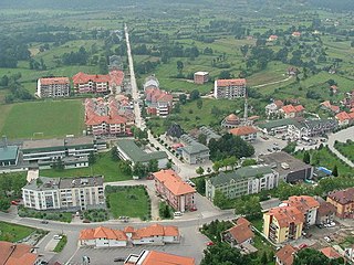
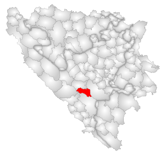
Kalesija is a town and municipality located in Tuzla Canton of the Federation of Bosnia and Herzegovina, an entity of Bosnia and Herzegovina. It is located in northeastern Bosnia and Herzegovina, east of Tuzla. As of 2013, the town has a population of 2,039 inhabitants, and the municipality has 33,053 inhabitants.
Jablanica is a common South Slavic toponym, derived from jablan, "Lombardy poplar", literally meaning "place of lombardy poplar". It may refer to:
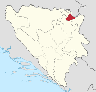
Brčko District officially the Brčko District of Bosnia and Herzegovina, is a self-governing administrative unit in north-eastern Bosnia and Herzegovina.

Ključ is a town and municipality located in the Una-Sana Canton of the Federation of Bosnia and Herzegovina, an entity of Bosnia and Herzegovina. The name of the town and the municipality translates to "Key" in English.

Trnovo is a municipality of the city of Istočno Sarajevo located in Republika Srpska, an entity of Bosnia and Herzegovina. As of 2013, it has a population of 2,050 inhabitants.
The Rzav is a river in western Serbia and eastern Bosnia and Herzegovina. The 72 km long right tributary to the Drina river, it originates from two headstreams, the Crni Rzav and the Beli Rzav. The river is sometimes referred to as the Zlatiborski Rzav.
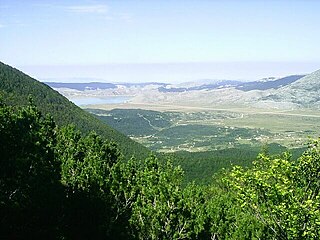
Blidinje Nature Park is a nature park in Bosnia and Herzegovina, established on 30 April 1995. It is situated at the Blidinje plateau, in the heart of Dinaric Alps, between major mountains of the range, Čvrsnica, Čabulja and Vran, with characteristic karstic features such as Dugopolje field, Blidinje Lake, Grabovica and Drežanka valleys, and others. It represents important natural, hydrogeological reserves in Dinaric karst of Bosnia and Herzegovina, with significant cultural and historical heritage.

Konjic is a city and municipality located in Herzegovina-Neretva Canton of the Federation of Bosnia and Herzegovina. It is located in northern Herzegovina, around 60 kilometres (37 mi) southwest of Sarajevo. It is a mountainous, heavily wooded area, and is 268 m (879 ft) above sea level. The municipality extends on both sides of the Neretva River. As of 2013, it has a population of 26,381 inhabitants.

Herzegovina is the southern and smaller of two main geographical regions of Bosnia and Herzegovina, the other being Bosnia. It has never had strictly defined geographical or cultural-historical borders, nor has it ever been defined as an administrative whole in the geopolitical and economic subdivision of Bosnia and Herzegovina.
Donje Ravno is a village in the municipality of Kupres, Bosnia and Herzegovina.
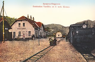
Donje Vardište is a village in the municipality of Višegrad, Bosnia and Herzegovina. It is on the border between Serbia and Bosnia and Herzegovina. Donje Vardište was one of the two end stations of the Bosnian Eastern Railway, which had been built from Sarajevo to Uvac and Vardište during the Austro-Hungarian rule in Bosnia and Herzegovina. Construction of the line started in 1903. It was completed in 1906, using the 760 mm track gauge. With the cost of 75 million gold crowns, which approximately translates to 450 thousand gold crowns per kilometer, it was one of the most expensive railways in the world built by that time. The line was eventually extended to Belgrade in 1928. Donje Vardište is today part of the narrow-gauge heritage railway Šargan Eight.
Jablanica (Višegrad) is a village in the municipality of Višegrad, Bosnia and Herzegovina.
Čehari is a village in the municipality of Jablanica, Bosnia and Herzegovina.
Dobrigošće is a village in the municipality of Jablanica, Bosnia and Herzegovina.
Donja Jablanica is a village in the municipality of Jablanica, Bosnia and Herzegovina.


