Dos Cuadras Offshore Oil Field

Last updated
Platform A, Dos Cuadras Oilfield, 2006 photo. The 1969 Santa Barbara Oil Spill originated from this platform. Platform A, Dos Cuadras (1).jpg
Platform A, Dos Cuadras Oilfield, 2006 photo. The 1969 Santa Barbara Oil Spill originated from this platform.
The four platforms producing from the Dos Cuadras Field, as seen from Summerland, California. They are, in order from left to right: Platforms Hillhouse, "A", "B", and "C". Santa Cruz Island in background. DosCuadrasFour.jpg
The four platforms producing from the Dos Cuadras Field, as seen from Summerland, California. They are, in order from left to right: Platforms Hillhouse, "A", "B", and "C". Santa Cruz Island in background.

The Dos Cuadras Offshore Oil Field is a large oil and gas field underneath the Santa Barbara Channel about eight miles southeast of Santa Barbara, California. Discovered in 1968, and with a cumulative production of over 260 million barrels of oil, it is the 24th-largest oil field within California and the adjacent waters. [1] As it is in the Pacific Ocean outside of the 3-mile tidelands limit, it is a federally leased field, regulated by the U.S. Department of the Interior rather than the California Department of Conservation. It is entirely produced from four drilling and production platforms in the channel, which as of 2009 were operated by Dos Cuadras Offshore Resources (DCOR), LLC, a private firm based in Ventura. A blowout near one of these platforms – Unocal's Platform A – was responsible for the 1969 Santa Barbara oil spill that was formative for the modern environmental movement, and spurred the passage of the National Environmental Policy Act.

Contents

Setting

The Dos Cuadras field is one of many underneath the ocean bottom offshore of Southern California, most of which were discovered in the 1960s and 1970s. All of the field is outside of the 3-mile geographic limit, making it subject to U.S. government rather than California regulation. The four platforms are arranged in a line running from east to west, spaced one-half mile apart, with Platform Hillhouse on the east, and Platforms "A", "B", and "C" in order to the west.

A pair of undersea pipelines, one for oil and one for gas, connect the four platforms to the shore near La Conchita. Oil and gas produced on the Dos Cuadras field are pumped about 12 miles east to the Rincon Oil & Gas Processing Plant on a hilltop adjacent to the Rincon Oil Field, about a mile southeast of La Conchita. From there oil travels down to Ventura along the M-143 pipeline to the Ventura pump station, and then to Los Angeles area refineries by way of a TOSCO pipeline in the Santa Clara River Valley. [2] [3]

The ocean bottom is relatively flat in the vicinity of the field, and all platforms are in a water depth of approximately 190 feet. [4]

Geology

Map showing relation of the Dos Cuadras Field to the Rincon anticlinal trend. DosCuadrasMap-USGS.jpg
Map showing relation of the Dos Cuadras Field to the Rincon anticlinal trend.

The Dos Cuadras field is a faulted anticlinal structure which plunges at both ends, thereby forming an ideal trap for hydrocarbon accumulation. It is part of the larger Rincon Anticlinal Trend, which includes the Carpinteria Offshore Oil Field to the east, as well as the Rincon, San Miguelito, and Ventura fields onshore. Oil is found in two formations, the Pliocene-age Pico Formation and the underlying Miocene Santa Margarita Formation. By far the most productive unit is the Repetto Sands portion of the Pico Formation. Only one well has produced from the Santa Margarita; all the others are in the Repetto Sands. [5]

The Repetto Sands unit consists of layers of mudstone, siltstone, and shale, and due to its depositional environment the general grain size and porosity increase towards the east. [6] It is the same formation which is richly productive in the oil fields of the Los Angeles Basin, such as the Salt Lake and Beverly Hills fields, where it is also folded into anticlinal traps. In the Dos Cuadras field, the oil-bearing strata are at depths ranging from 500 to 4,200 feet below the sea floor, and individual strata are separated by impermeable layers of shaly material. [6]

Oil from the field averages API gravity of 25, with a range from 18 to 34, which classifies as medium-grade crude. Reservoir pressure began at 750 psi, sufficient for easy pumping in the early years of field development. [4]

History and production

Oil has been known in the Santa Barbara Channel since prehistoric times; the native Chumash people used tar from the numerous natural seeps as a sealant, and tar regularly washes up on the beaches from the offshore seeps. The world's first offshore oil drilling took place at the Summerland Oil Field in 1896, only five miles north of the Dos Cuadras field. Those wells were put in from piers in shallow water. Technology for drilling in deeper water from platforms did not come about until the middle of the 20th century.

While the existence of the field was suspected in the 1950s, the field was not discovered until 1968. Unocal and several other oil companies took out leases on the field in February 1968, and put in the first well, and the first platform, that same year. [7] [8] Data regarding the four platforms are as follows: [9]

NameInstalledFirst productionWater depth
Platform ASeptember 14, 1968March 3, 1969188 feet
Platform BNovember 8, 1968July 19, 1969190 feet
Platform HillhouseNovember 26, 1969July 21, 1970190 feet
Platform CFebruary 28, 1977August 1, 1977192 feet
"Hillhouse" platform, Dos Cuadras. 2006 photo by Doc Searls. Platform Hillhouse, Dos Cuadras (7).jpg
"Hillhouse" platform, Dos Cuadras. 2006 photo by Doc Searls.
Platform C, Dos Cuadras, 2006 Platform C, Dos Cuadras (7).jpg
Platform C, Dos Cuadras, 2006

Unocal succeeded in installing the first four wells from its Platform A by January 1969, but their attempt to install the fifth well was catastrophic, and resulted in one of the most notorious environmental disasters in United States history. Because the drillers were using an insufficient length of protective casing, when the well hit a high-pressure zone in the field, it blew out, spewing enormous quantities of oil and gas into the water from the sea floor. While crews were able to cap the wellhead and relieve the pressure there, the adjacent geologic formations were not strong enough to contain the pressure, and lacking a steel protective casing, the reservoir fluid and gas ripped through the sedimentary sand layers directly on the ocean floor; the result was the 1969 Santa Barbara oil spill of 80,000 to 100,000 barrels, which eventually coated over 40 miles of southern California coastline with oil, an ecological disaster which killed upward of 10,000 birds and numerous sea mammals and other creatures. [10] [11]


Following the spill, the Secretary of the Interior ended all offshore oil drilling in the Outer Continental Shelf (OCS) until measures for better oversight were put in place, which happened in 1970 with the passage of the federal National Environmental Policy Act (NEPA), and in California, with the California Environmental Quality Act (CEQA). Opposition to oil drilling was nothing new in Santa Barbara – local residents, led by a newspaper publisher, objected enough to the expansion of the Summerland field in the 1890s to organize a late-night derrick-destroying party near the present-day Miramar Hotel [12] – but the spill intensified the local hostility to oil drilling to the point that few new platforms were installed, and none at all within the 3-mile limit.

After the disaster and cleanup, Unocal continued drilling wells from the two platforms that were already in place ("A" and "B", began producing from them in March 1969, and installed two more platforms ("C" and "Hillhouse"). Production from the field peaked quickly, reaching a maximum in 1971, during which year almost 28 million barrels of oil were extracted. The field experienced a gradual decline in production afterwards, approximately 8 percent per year, as is typical of fields when the reservoir pressure declines, and in the absence of secondary recovery technologies (such as water or gas injection). In 1985, Unocal tried waterflooding, and then polymer flooding, to improve production rates, and then in 1990 they began a horizontal drilling program to reach reservoirs impractical to exploit any other way. [5]

Unocal continued to produce from the field until they sold all of their California production assets in 1996 to Nuevo Energy, as operated by Torch Energy Advisors. [13] In 1997 Nuevo took over the operations of the four platforms directly, and in 2004 passed them on to Plains Exploration & Production on that firm's acquisition of Nuevo. Plains only ran the platforms for a little more than four months, selling the operation to DCOR in March 2005. As of 2009, DCOR retains operational control of the Dos Cuadras field. [14]

According to the Minerals Management Service (MMS), the field retains about 11.4 million barrels of oil in reserves recoverable with current technology. At the beginning of 2008, there were 145 producing oil wells distributed between the four platforms. [15] [1]

Related Research Articles

<span class="mw-page-title-main">Santa Barbara Channel</span> Pacific Ocean separating California from northern Channel Islands

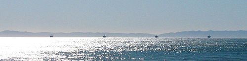
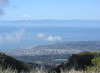
The Santa Barbara Channel is a portion of the Southern California Bight and separates the mainland of California from the northern Channel Islands. It is generally south of the city of Santa Barbara, and west of the Oxnard Plain in Ventura County.

<span class="mw-page-title-main">Offshore drilling</span> Mechanical process where a wellbore is drilled below the seabed

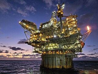
Offshore drilling is a mechanical process where a wellbore is drilled below the seabed. It is typically carried out in order to explore for and subsequently extract petroleum that lies in rock formations beneath the seabed. Most commonly, the term is used to describe drilling activities on the continental shelf, though the term can also be applied to drilling in lakes, inshore waters and inland seas.

<span class="mw-page-title-main">Rincon Island (California)</span> Artificial island for oil well drilling offshore of Ventura County, California

Rincon Island is a small 2.3-acre artificial island located off Mussel Shoals in Ventura County, California on public land leased from the California State Lands Commission (CSLC). The island is situated approximately 3,000 feet (910 m) offshore in 55 feet (17 m) of water. The island was constructed in 1958 for the specific purpose of well drilling and oil and gas production. It is near the seaside communities of Mussel Shoals and La Conchita. The island is connected to the mainland by the Richfield Pier.

<span class="mw-page-title-main">1969 Santa Barbara oil spill</span> Oil platform blow-out fouled the coast of California resulting in environmental legislation

The Santa Barbara oil spill occurred in January and February 1969 in the Santa Barbara Channel, near the city of Santa Barbara in Southern California. It was the largest oil spill in United States waters at the time, and now ranks third after the 2010 Deepwater Horizon and 1989 Exxon Valdez spills. It remains the largest oil spill to have occurred in the waters off California.

<span class="mw-page-title-main">Ellwood Oil Field</span> Partially active, adjoining Goleta, California

Ellwood Oil Field and South Ellwood Offshore Oil Field are a pair of adjacent, partially active oil fields adjoining the city of Goleta, California, about twelve miles (19 km) west of Santa Barbara, largely in the Santa Barbara Channel. A richly productive field in the 1930s, the Ellwood Oil Field was important to the economic development of the Santa Barbara area. A Japanese submarine shelled the area during World War II. It was the first direct naval bombardment of the continental U.S. since the Civil War, causing an invasion scare on the West Coast.

<span class="mw-page-title-main">Offshore oil and gas in the United States</span> Large portion of oil and gas supply

Offshore oil and gas in the United States provides a large portion of the nation’s oil and gas supply. Large oil and gas reservoirs are found under the sea offshore from Louisiana, Texas, California, and Alaska. Environmental concerns have prevented or restricted offshore drilling in some areas, and the issue has been hotly debated at the local and national levels.

<span class="mw-page-title-main">Offshore oil and gas in California</span> Drilling in state and federal zones

Offshore oil and gas in California provides a significant portion of the state's petroleum production. Offshore oil and gas has been a contentious issue for decades, first over the question of state versus federal ownership, but since 1969 mostly over questions of resource development versus environmental protection.

<span class="mw-page-title-main">Greka Energy</span>

Greka Energy, legally HVI Cat Canyon Inc., is a privately held company engaged in hydrocarbon exploration principally in Santa Barbara County, California. Formed in 1999 after the acquisition and merger of several smaller firms, it is a subsidiary of Greka Integrated, Inc., a holding company headquartered in Santa Maria, California, and is wholly owned by Randeep Grewal.

<span class="mw-page-title-main">Ventura Oil Field</span> Oil field adjacent to the city of Ventura, California, United States

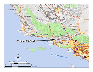
The Ventura Oil Field is a large and currently productive oil field in the hills immediately north of the city of Ventura in southern California in the United States. It is bisected by California State Route 33, the freeway connecting Ventura to Ojai, and is about eight miles (13 km) long by two across, with the long axis aligned east to west. Discovered in 1919, and with a cumulative production of just under a billion barrels of oil as of 2008, it is the tenth-largest producing oil field in California, retaining approximately 50 million barrels in reserve, and had 423 wells still producing. As of 2009 it was entirely operated by Aera Energy LLC.

<span class="mw-page-title-main">Summerland Oil Field</span>

The Summerland Oil Field is an inactive oil field in Santa Barbara County, California, about four miles (6 km) east of the city of Santa Barbara, within and next to the unincorporated community of Summerland. First developed in the 1890s, and richly productive in the early 20th century, the Summerland Oil Field was the location of the world's first offshore oil wells, drilled from piers in 1896. This field, which was the first significant field to be developed in Santa Barbara County, produced 3.18 million of barrels of oil during its 50-year lifespan, finally being abandoned in 1939-40. Another nearby oil field entirely offshore, discovered in 1957 and named the Summerland Offshore Oil Field, produced from two drilling platforms in the Santa Barbara Channel before being abandoned in 1996.

<span class="mw-page-title-main">Rincon Oil Field</span> Large oil field on the central coast of southern California

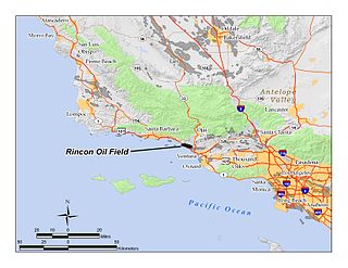
The Rincon Oil Field is a large oil field on the coast of southern California, about 10 miles (16 km) northwest of the city of Ventura, and about 20 miles (32 km) east-southeast of the city of Santa Barbara. It is the westernmost onshore field in a series of three fields which follow the Ventura Anticline, an east-west trending feature paralleling the Transverse Ranges. Discovered in 1927, the oil field is ranked 36th in California by size of recoverable oil reserves, and while mostly depleted – now having, by California Department of Conservation estimates, only about 2.5% of its original oil – it remains productive, with 77 wells active at the beginning of 2008. Oil produced in the field flows through the M-143 pipeline, which parallels U.S. Highway 101 southeast to the Ventura Pump Station, at which point it joins a Tosco pipeline which carries it to Los Angeles area refineries. As of 2009, the primary operators of the field were Occidental Petroleum for the onshore portion, and Greka Energy for the offshore portion. The offshore part of the field is operated mainly from Rincon Island.

<span class="mw-page-title-main">Lompoc Oil Field</span> Oil field in California, United States

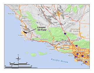
The Lompoc Oil Field is a large oil field in the Purisima Hills north of Lompoc, California, in Santa Barbara County. Discovered in 1903, two years after the discovery of the Orcutt Oil Field in the Solomon Hills, it is one of the oldest oil fields in northern Santa Barbara County, and one of the closest to exhaustion, reporting only 1.7 million barrels (270,000 m3) of recoverable oil remaining out of its original 50 million barrels (7,900,000 m3) as of the end of 2008. Its sole operator is Sentinel Peak Resources, who acquired it from Freeport-McMoRan. In 2009, the proposed decommissioning and habitat restoration of the 3,700-acre (15 km2) field was part of a controversial and so-far unsuccessful deal between Plains, several environmental groups, Santa Barbara County, and the State of California, to allow Plains to carry out new offshore oil drilling on the Tranquillon Ridge, in the Pacific Ocean about twenty miles (32 km) southwest of the Lompoc field.

<span class="mw-page-title-main">San Miguelito Oil Field</span> Oil field near Ventura, California

The San Miguelito Oil Field is a large and currently productive oil field in the hills northwest of the city of Ventura in southern California in the United States. The field is close to the coastline, with U.S. Highway 101 running past at the base of the hills and is sandwiched between the larger Ventura Oil Field to the east and the Rincon Oil Field, which is partially offshore, to the north and northwest. Discovered in 1931, and with about 7 million barrels of oil remaining out of its original 125 million, it ranks 44th in the state by size, and at the beginning of 2009 had 61 producing oil wells, all operated by Vintage Production California LLC, a subsidiary of Occidental Petroleum.

<span class="mw-page-title-main">Carpinteria Offshore Oil Field</span>

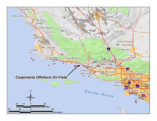
The Carpinteria Offshore Oil Field is an oil and gas field in Santa Barbara Channel, south of the city of Carpinteria in southern California in the United States. Discovered in 1964, and reaching peak production in 1969, it has produced over 106 million barrels of oil in its lifetime, and retains approximately 2 million barrels in reserve recoverable with present technology, according to the California State Department of Natural Resources. Currently the field is produced from three drilling platforms four to five miles offshore, within Federal waters outside of the tidelands zone. Two of the platforms are operated by Pacific Operators Offshore LLC (PACOPS), the operating arm of Carpinteria-based Carone Petroleum; the other platform is operated by Dos Cuadras Offshore Resources (DCOR). The Carpinteria field is the 50th largest field in California by total original oil in place, as of the end of 2008.

<span class="mw-page-title-main">Mesa Oil Field</span>

The Mesa Oil Field is an abandoned oil field entirely within the city limits of Santa Barbara, California, in the United States. Discovered in 1929, it was quickly developed and quickly declined, as it proved to be but a relatively small accumulation of oil in a single geologic formation. While the field was active in the 1930s, residential development in most of the Mesa neighborhood of Santa Barbara came to a halt. The field included two major productive areas with a total surface extent of only 210 acres (0.85 km2), and produced 3,700,000 barrels (590,000 m3) of oil during its brief lifetime.

<span class="mw-page-title-main">Rincon Formation</span>

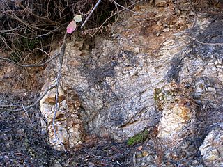
The Rincon Formation is a sedimentary geologic unit of Lower Miocene age, abundant in the coastal portions of southern Santa Barbara County, California eastward into Ventura County. Consisting of massive to poorly bedded shale, mudstone, and siltstone, it weathers readily to a rounded hilly topography with clayey, loamy soils in which landslides and slumps are frequent. It is recognizable on the south slopes of the Santa Ynez Mountains as the band at the base of the mountains which supports grasses rather than chaparral. Outcrops of the unit are infrequent, with the best exposures on the coastal bluffs near Naples, in the San Marcos Foothills, at the Tajiguas Landfill, and in road cuts. The geologic unit is notorious as a source of radon gas related to its high uranium content, released by radioactive decay.

<span class="mw-page-title-main">Matilija Sandstone</span> Southern California geological formation

The Matilija Sandstone is a sedimentary geologic unit of Eocene epoch in the Paleogene Period, found in Santa Barbara and Ventura Counties in Southern California.

<span class="mw-page-title-main">California oil and gas industry</span> The oil and gas industry of the US state of California

The California oil and gas industry has been a major economic and cultural component of the US state of California for over a century. Oil production was a minor factor in the 19th century, with kerosene replacing whale oil and lubricants becoming essential to the machine age. Oil became a major California industry in the 20th century with the discovery on new fields around Los Angeles and the San Joaquin Valley, and the dramatic increase in demand for gasoline to fuel automobiles and trucks. In 1900 California pumped 4 million barrels (640,000 m3), nearly 5% of the national supply. Then came a series of major discoveries, and the state pumped 100 million bbl (16 million m3) in 1914, or 38% of the national supply. In 2012 California produced 197 million bbl (31 million m3) of crude oil, out of the total 2,375 million bbl (378 million m3) of oil produced in the US, representing 8.3% of national production. California drilling operations and oil production are concentrated primarily in Kern County, San Joaquin Valley and the Los Angeles basin.

<span class="mw-page-title-main">Refugio oil spill</span> 2015 pipeline leak on the coast of California

The Refugio oil spill on May 19, 2015, contaminated one of the most biologically diverse areas of the West Coast of the United States with 142,800 U.S. gallons of crude oil. The corroded pipeline that caused the spill closed indefinitely, resulting in financial impacts to the county estimated as high as $74 million as it and a related pipeline remained out of service for three years. The cost of the cleanup was estimated by the company to be $96 million with overall expenses including expected legal claims and potential settlements to be around $257 million.

<span class="mw-page-title-main">La Goleta Gas Field</span> Natural gas field in Santa Barbara County, California, United States

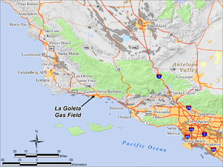
The La Goleta Gas Field is a natural gas field in unincorporated Santa Barbara County, California, adjacent to the city of Goleta. Discovered in 1929, and first put into production in 1932, it has been in continuous use ever since, producing approximately 12 billion cubic feet of gas. With production declining, the field was converted into a gas storage reservoir in 1941. As of 2016 it remains one of the four gas storage facilities maintained by Southern California Gas Company (SoCalGas), a division of Sempra Energy, with the others being Aliso Canyon, Honor Rancho and Playa del Rey. It is the oldest storage facility of the four and the third largest, with a maximum capacity of 21.5 billion cubic feet. The storage facilities are necessary to balance load for the over ten million customers of SoCalGas: during summer months, when gas usage is at a minimum, gas is pumped into the reservoirs; and in the winter when usage is high, gas is withdrawn. The La Goleta field serves the northern portion of SoCalGas's geographic range.

References

Notes

  1. 1 2 "Oil and Gas Statistics: 2007 Annual Report" (PDF). California Department of Conservation. December 31, 2007. Archived from the original (PDF) on 2019-04-12. Retrieved August 25, 2009.
  2. Hargis, Dean (January 26, 2000). "California Offshore Oil and Gas Energy Resources Study" (PDF). California Department of Conservation. Minerals Management Service, U.S. Department of the Interior. Archived from the original (PDF) on July 6, 2010. Retrieved December 30, 2009.
  3. "APCD Permit to Operate No. 9110-R3, p. 8" (PDF). Archived from the original (PDF) on 2011-07-17. Retrieved 2009-12-31.
  4. 1 2 Vassilieva, Svetlana (1999). Evaluation of horizontal wells in an offshore reservoir in Southern California (PDF) (MS thesis). Stanford University. Archived from the original (PDF) on 30 January 2016. Retrieved 31 December 2009. p. 16
  5. 1 2 Vassilieva, p. 17
  6. 1 2 Vassilieva, p. 15
  7. DOGGR, p. 614-615
  8. Vassilieva, p. 14
  9. "Minerals Management Service: Dos Cuadras Field platform information". Archived from the original on 2010-05-28. Retrieved 2009-12-31.
  10. Brief oil and gas history of Santa Barbara County Archived 2011-05-27 at the Wayback Machine
  11. Haier, Daniel Haier (2005-01-28). "69 Oil Spill Leaves Mark on SB Environmentalism" (PDF). Daily Nexus, UCSB. Archived from the original (PDF) on 2016-08-17. Retrieved 2010-01-02.
  12. Tompkins, Walker A. (1975). Santa Barbara, Past and Present. Santa Barbara, California: Tecolote Books. p. 80.
  13. New York Times: Unocal to sell oil and gas fields in California, February 21, 1996
  14. Minerals Management Service: Lease operatorship book Archived 2010-05-28 at the Wayback Machine
  15. "Minerals Management Service, Pacific OCS Region: Field Reserve Estimate Summary, December 2008" (PDF). U.S. Minerals Management Service. December 2008. Archived from the original (PDF) on July 5, 2010. Retrieved December 30, 2009.

34°20′48″N119°37′06″W / 34.3466°N 119.6184°W / 34.3466; -119.6184