
Rincon Island is a small 2.3-acre artificial island located off Mussel Shoals in Ventura County, California on public land leased from the California State Lands Commission (CSLC). The island is situated approximately 3,000 feet (910 m) offshore in 55 feet (17 m) of water. The island was constructed in 1958 for the specific purpose of well drilling and oil and gas production. It is near the seaside communities of Mussel Shoals and La Conchita. The island is connected to the mainland by the Richfield Pier.
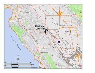
The Coalinga Oil Field is a large oil field in western Fresno County, California, in the United States. It surrounds the town of Coalinga, about halfway between Los Angeles and San Francisco, to the west of Interstate 5, at the foot of the Diablo Range. Discovered in the late 19th century, it became active around 1890, and is now the eighth-largest oil field in California, with reserves totaling approximately 58 million barrels (9,200,000 m3), and over 1,600 active oil wells. The principal operators on the field, as of 2008, were Chevron Corp. and Aera Energy LLC.

Ellwood Oil Field and South Ellwood Offshore Oil Field are a pair of adjacent, partially active oil fields adjoining the city of Goleta, California, about twelve miles (19 km) west of Santa Barbara, largely in the Santa Barbara Channel. A richly productive field in the 1930s, the Ellwood Oil Field was important to the economic development of the Santa Barbara area. The Japanese submarine I-17 shelled the area during World War II. It was the first direct naval bombardment of the continentital U.S. since the Civil War, causing an invasion scare on the West Coast.
Greka Energy, legally HVI Cat Canyon Inc., is a privately held company engaged in hydrocarbon exploration principally in Santa Barbara County, California. Formed in 1999 after the acquisition and merger of several smaller firms, it is a subsidiary of Greka Integrated, Inc., a holding company headquartered in Santa Maria, California, and is wholly owned by Randeep Grewal.
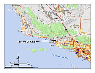
The Ventura Oil Field is a large and currently productive oil field in the hills immediately north of the city of Ventura in southern California in the United States. It is bisected by California State Route 33, the freeway connecting Ventura to Ojai, and is about eight miles (13 km) long by two across, with the long axis aligned east to west. Discovered in 1919, and with a cumulative production of just under a billion barrels of oil as of 2008, it is the tenth-largest producing oil field in California, retaining approximately 50 million barrels in reserve, and had 423 wells still producing. As of 2009 it was entirely operated by Aera Energy LLC.

The Summerland Oil Field is an inactive oil field in Santa Barbara County, California, about four miles (6 km) east of the city of Santa Barbara, within and next to the unincorporated community of Summerland. First developed in the 1890s, and richly productive in the early 20th century, the Summerland Oil Field was the location of the world's first offshore oil wells, drilled from piers in 1896. This field, which was the first significant field to be developed in Santa Barbara County, produced 3.18 million of barrels of oil during its 50-year lifespan, finally being abandoned in 1939-40. Another nearby oil field entirely offshore, discovered in 1957 and named the Summerland Offshore Oil Field, produced from two drilling platforms in the Santa Barbara Channel before being abandoned in 1996.

The Dos Cuadras Offshore Oil Field is a large oil and gas field underneath the Santa Barbara Channel about eight miles southeast of Santa Barbara, California. Discovered in 1968, and with a cumulative production of over 260 million barrels of oil, it is the 24th-largest oil field within California and the adjacent waters. As it is in the Pacific Ocean outside of the 3-mile tidelands limit, it is a federally leased field, regulated by the U.S. Department of the Interior rather than the California Department of Conservation. It is entirely produced from four drilling and production platforms in the channel, which as of 2009 were operated by Dos Cuadras Offshore Resources (DCOR), LLC, a private firm based in Ventura. A blowout near one of these platforms – Unocal's Platform A – was responsible for the 1969 Santa Barbara oil spill that was formative for the modern environmental movement, and spurred the passage of the National Environmental Policy Act.
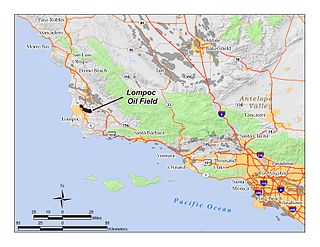
The Lompoc Oil Field is a large oil field in the Purisima Hills north of Lompoc, California, in Santa Barbara County. Discovered in 1903, two years after the discovery of the Orcutt Oil Field in the Solomon Hills, it is one of the oldest oil fields in northern Santa Barbara County, and one of the closest to exhaustion, reporting only 1.7 million barrels (270,000 m3) of recoverable oil remaining out of its original 50 million barrels (7,900,000 m3) as of the end of 2008. Its sole operator is Sentinel Peak Resources, who acquired it from Freeport-McMoRan. In 2009, the proposed decommissioning and habitat restoration of the 3,700-acre (15 km2) field was part of a controversial and so-far unsuccessful deal between Plains, several environmental groups, Santa Barbara County, and the State of California, to allow Plains to carry out new offshore oil drilling on the Tranquillon Ridge, in the Pacific Ocean about twenty miles (32 km) southwest of the Lompoc field.

The San Miguelito Oil Field is a large and currently productive oil field in the hills northwest of the city of Ventura in southern California in the United States. The field is close to the coastline, with U.S. Highway 101 running past at the base of the hills, and is sandwiched between the larger Ventura Oil Field to the east and the Rincon Oil Field, which is partially offshore, to the north and northwest. Discovered in 1931, and with about 7 million barrels of oil remaining out of its original 125 million, it ranks 44th in the state by size, and at the beginning of 2009 had 61 producing oil wells, all operated by Vintage Production California LLC, a subsidiary of Occidental Petroleum.
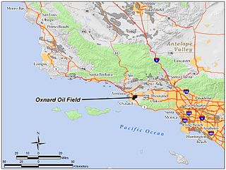
The Oxnard Oil Field is a large and currently productive oil field in and adjacent to the city of Oxnard, in Ventura County, California in the United States. Its conventional oil reserves are close to exhaustion, with only an estimated one percent of the original oil recoverable with current technology remaining: 434,000 barrels (69,000 m3) out of an original 43.5 million. However, the reservoir includes an enormous deposit of tar sands, ultra-heavy oil classed as an unconventional petroleum reserve, and potentially containing 400 million barrels (64,000,000 m3) of oil equivalent, should it become economically feasible to extract. Present operators on the field include Tri-Valley Oil & Gas Co., Anterra Energy Services, Inc., Chase Production Co., and Occidental Petroleum through its Vintage Production subsidiary. As of the beginning of 2009, there were 34 active wells on the field.

The West Montalvo Oil Field is a large and productive oil field on the coast of Ventura County, California, in the United States, in and adjacent to the city of Oxnard, California. Discovered in 1947, it has produced approximately 43.7 million barrels (6,950,000 m3) of oil, and retains about 2.2 million recoverable with current technology, in both the onshore and offshore areas. The offshore portion of the field is exploited from wells directionally drilled from onshore near McGrath Lake, from within an enclosure above the high-tide line at McGrath State Beach.

The Saticoy Oil Field is an oil and gas field in Ventura County, California, in the United States. The field is a long narrow band paralleling the Santa Clara River near the town of Saticoy. Discovered in 1955, it is one of the smaller but productive fields found in the region after most of the large fields had already been operational for decades. At the beginning of 2009 it still contained an estimated 387,000 barrels (61,500 m3) of recoverable oil out of its original 23.5 million, and had 15 wells remaining in operation. Vintage Production, a subsidiary of Occidental Petroleum, was the primary operator on the field as of 2009.

The South Mountain Oil Field is a large and productive oil field in Ventura County, California, in the United States, in and adjacent to the city of Santa Paula. Discovered in 1916, and having a cumulative production of over 158 million barrels (25,100,000 m3) of oil, it is the 37th largest oil field in California and the second largest in Ventura County. As of the beginning of 2009, it retains 316 active wells, and has an estimated 1.4 million barrels (220,000 m3) of oil remaining recoverable with current technology. Vintage Production, a subsidiary of Occidental Petroleum, was the largest operator as of 2009.

The Guijarral Hills Oil Field is a formerly-productive oil and gas field near Coalinga on the western side of the Central Valley in central California in the United States. Discovered in 1948, and having produced 5.4 million barrels (860,000 m3) of oil during its peak year in 1950, it now has but one active oil well producing a little over a barrel of oil a day, and is very near to exhaustion, with only 343,000 recoverable barrels of oil remaining throughout its 2,515-acre (10.18 km2) extent according to the official California State Department of Conservation estimate. As of 2010, the only active operator was Longview Production Company.
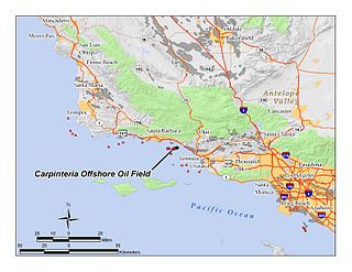
The Carpinteria Offshore Oil Field is an oil and gas field in Santa Barbara Channel, south of the city of Carpinteria in southern California in the United States. Discovered in 1964, and reaching peak production in 1969, it has produced over 106 million barrels of oil in its lifetime, and retains approximately 2 million barrels in reserve recoverable with present technology, according to the California State Department of Natural Resources. Currently the field is produced from three drilling platforms four to five miles offshore, within Federal waters outside of the tidelands zone. Two of the platforms are operated by Pacific Operators Offshore LLC (PACOPS), the operating arm of Carpinteria-based Carone Petroleum; the other platform is operated by Dos Cuadras Offshore Resources (DCOR). The Carpinteria field is the 50th largest field in California by total original oil in place, as of the end of 2008.

The Mesa Oil Field is an abandoned oil field entirely within the city limits of Santa Barbara, California, in the United States. Discovered in 1929, it was quickly developed and quickly declined, as it proved to be but a relatively small accumulation of oil in a single geologic formation. While the field was active in the 1930s, residential development in most of the Mesa neighborhood of Santa Barbara came to a halt. The field included two major productive areas with a total surface extent of only 210 acres (0.85 km2), and produced 3,700,000 barrels (590,000 m3) of oil during its brief lifetime.
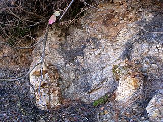
The Rincon Formation is a sedimentary geologic unit of Lower Miocene age, abundant in the coastal portions of southern Santa Barbara County, California eastward into Ventura County. Consisting of massive to poorly bedded shale, mudstone, and siltstone, it weathers readily to a rounded hilly topography with clayey, loamy soils in which landslides and slumps are frequent. It is recognizable on the south slopes of the Santa Ynez Mountains as the band at the base of the mountains which supports grasses rather than chaparral. Outcrops of the unit are infrequent, with the best exposures on the coastal bluffs near Naples, in the San Marcos Foothills, at the Tajiguas Landfill, and in road cuts. The geologic unit is notorious as a source of radon gas related to its high uranium content, released by radioactive decay.
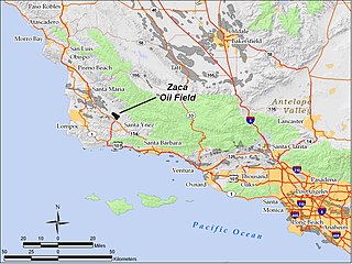
The Zaca Oil Field is an oil field in central Santa Barbara County, California, about 20 miles southeast of Santa Maria. One of several oil fields in the county which produce heavy oil from the Monterey Formation, the field is hidden within a region of rolling hills, north of the Santa Ynez Valley. As of 2011, the principal operator of the oil field is Greka Energy and the operator of the "Zaca Field Extension Project" is Underground Energy. The field is known to contain heavy crude oil and Underground Energy has recently discovered a lower sub-thrust block in the field, which was not previously produced by the field's historical operators. The field was discovered in 1942, reached peak production in 1954, and remains active with more than thirty oil wells and continues to grow.
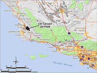
The Cat Canyon Oil Field is a large oil field in the Solomon Hills of central Santa Barbara County, California, about 10 miles southeast of Santa Maria. It is the largest oil field in Santa Barbara County, and as of 2010 is the 20th-largest in California by cumulative production.

The Honor Rancho Oil Field is an approximately 600-acre oil field and natural gas storage facility in Los Angeles County, California, on the northern border of the Valencia neighborhood of Santa Clarita, near the junction of Interstate 5 and westbound California State Route 126. Discovered in 1950 and quickly developed, the field's oil production peaked in the 1950s, but remains productive in 2016. In 1975 Southern California Gas Company (SoCalGas), the gas utility serving Southern California, began using one of its depleted oil producing zones, the Wayside 13 zone, as a gas storage reservoir, and it became the second-largest in their inventory after the Aliso Canyon gas storage facility. The field shares part of its extent with the Peter J. Pitchess Detention Center, which includes a maximum-security prison.


