Beverly Hills Oil Field

Last updated
Location of the Beverly Hills Oil Field in the context of the Los Angeles Basin and Southern California. Other oil fields are shown in gray. BeverlyHillsOilField.png
Location of the Beverly Hills Oil Field in the context of the Los Angeles Basin and Southern California. Other oil fields are shown in gray.

The Beverly Hills Oil Field is a large and currently active oil field underneath part of the US cities of Beverly Hills, California, and portions of the adjacent city of Los Angeles. Discovered in 1900, and with a cumulative production of over 150 million barrels of oil, it ranks 39th by size among California's oil fields, and is unusual for being a large, continuously productive field in an entirely urban setting. All drilling, pumping, and processing operations for the 97 [1] currently active wells are done from within four large "drilling islands", visible on Pico and Olympic boulevards as large windowless buildings, from which wells slant diagonally into different parts of the producing formations, directly underneath the multimillion-dollar residences and commercial structures of one of the wealthiest cities in the United States. Annual production from the field was 1.09 million barrels in 2006, 966,000 barrels in 2007, and 874,000 in 2008, and the field retains approximately 11 million barrels of oil in reserve, as estimated by the California Department of Conservation. [1] [2] The largest operators as of 2009 were independent oil companies Plains Exploration & Production and BreitBurn Energy. [3]

Contents

Setting

Detail of the Beverly Hills Oil Field, showing its position relative to Beverly Hills and Los Angeles, and also showing the locations of the four active drilling islands. A fifth, inactive drilling island west of Beverly Hills High School is not shown. BHDetail.jpg
Detail of the Beverly Hills Oil Field, showing its position relative to Beverly Hills and Los Angeles, and also showing the locations of the four active drilling islands. A fifth, inactive drilling island west of Beverly Hills High School is not shown.

While the oil field is unusual for being entirely within the confines of a large city, it is but one of many in the Los Angeles basin which are now overbuilt by dense residential and commercial development. The field is long and narrow, about four miles (6 km) long by a half-mile to mile across. Its long axis is aligned in a generally east-west direction, extending from the vicinity of the intersection of Santa Monica Boulevard and Beverly Glen on the west, east along Pico Boulevard, past La Cienega and Fairfax Avenue, to around the intersection of Pico and Hauser. From north to south the field is much narrower, extending near the middle of the field from near Monte Mar Drive in Los Angeles to about two blocks north of Olympic Boulevard in Beverly Hills. The total productive area of the field, projected to ground surface, covers about 1,200 acres (4.9 km2). [4]

In most oil fields, wells are drilled at optimum spacing for petroleum extraction with the boreholes going straight down into the target formations. Since this method of field development is not possible in a large city with no open land, all the wells tapping into the Beverly Hills field are clustered into four drilling islands—oil production and processing facilities tightly packed into windowless, soundproofed buildings—so as to have a minimal impact on adjacent land uses. The westernmost of these buildings, containing wells and which accesses the designated West Area of the field, is on the grounds of Beverly Hills High School at the corner of Olympic Boulevard and Heath Avenue, just southeast of the baseball diamond. This facility also houses storage tanks, several oil-water separator units, a pump house, compressor house, and an office building. [5]

A facility similar to the one adjacent to Beverly Hills High School, operated by BreitBurn Energy, is north of Pico between Doheny Drive and Cardiff Ave. Yet another drilling island, the largest of the four, containing over fifty active wells and operated by Plains Exploration & Production, is north of Pico between Genesee Avenue and Spaulding Avenue. This drilling island also contains wells that angle northeast into the Salt Lake Oil Field. Within the boundary of the adjacent Cheviot Hills Oil Field, and on the grounds of the Hillcrest Country Club about 500 feet (150 m) south of the intersection of Pico Boulevard and Century Hill East, is a fourth, smaller drilling island, operated by Hillcrest Beverly Oil Corp. This small drilling island includes 12 active wells directionally drilled into the Beverly Hills Oil Field, as well as several others drilled into the Cheviot Hills Field. [6]

The operators of a fifth drilling island, located at the northern corner of Avenue of the Stars and Constellation Boulevard in Century City, finished abandoning it in 1990. Originally constructed in the 1950s on what was then an unused back lot of Twentieth Century Fox Studios, its production steadily declined in the 1970s, and by 1989 the last well was shut down. Land use changes and soaring real estate values contributed to its elimination. [7]

The city of Los Angeles handles all building permits and air permitting issues for the oil field. [8]

Geology

Beverly Hills Oil Field Structure Map BeverlyHillsOilFieIdStructureMap.png
Beverly Hills Oil Field Structure Map

The field is a faulted anticlinal structure with oil trapped by a combination of structural and stratigraphic mechanisms. Bounding the field on the south is the Brentwood-Las Cienegas Fault, and the field ends on the west near the Santa Monica Fault Complex. The minimum depth to the larger deposits of profitably extractable oil varies from about 5600 to about 7,200 feet (2,200 m) below ground surface, or 5400 to 7,000 feet (2,100 m) below sea level (as the approximate elevation of this portion of the Los Angeles Basin is about 200 feet). [4]

The uppermost producing unit was the first to be discovered, and consists of oil-bearing structures called the Wolfskill Zone, within the Repetto Sands, a Pliocene-age feature principally in the western part of the field. Oil in these sands is mainly found in pinch-out structures, in which oil is trapped in more permeable sub-units within impermeable sands. Underneath this unit, separated by an unconformity, is the larger Modelo Formation, consisting of several sand units: the D/M Sands (the topmost), the Hauser Sand, around 4,500 feet (1,400 m) below sea level, and the Ogden Sand, around 7,200 feet (2,200 m) below sea level. Beneath the Ogden Sand is a nodular shale unit, also grouped with the Modelo; it contains no oil. Both the Ogden and the Hauser are richly productive, while a few oil-bearing pinch-outs are found in the D/M sand, which otherwise forms an impermeable cap to the Hauser. [4] The deepest unit in the field which is being pumped is a portion of the Ogden Sands in the East Area of the field, discovered in 1967, which is at an average depth of 10,800 feet (3,300 m). [9]

According to BreitBurn Energy, one of the two principal producers on the eastern part of the field, there were 600 million barrels of oil originally in place; since 111 million have been recovered, about 489 million remain. They do not state what percentage of that reserve is recoverable using current technologies. [10]

History, production, and operations

BreitBurn Drilling Island Breitburn Drilling Rig.jpg
BreitBurn Drilling Island

Oil was discovered in the northern Los Angeles basin in 1893, not far from the city center, and development of the Los Angeles City Oil Field was fast. By 1895, that field was producing over half of the oil in the state, and drillers began looking for even more new oil prospects around the basin, attempting to match the enormous finds taking place simultaneously just over the Tehachapis in Kern County. [11] In July 1900, W.W. Orcutt drilled into the Wolfskill zone of the Repetto Sands, about 2,500 feet (760 m) below ground surface, discovering the Beverly Hills Field. [4] While the oil was of reasonably good quality—it was light, with a high API gravity between 33 and 60, although with a high sulfur content—development was slow, since the Wolfskill find was relatively small, and other fields in the Los Angeles basin were growing almost as fast as operators could drill new wells.

The eastern portion of the field—known simply as the East Area—is the most productive, and is also the most recently discovered of all the major oil fields in the Los Angeles Basin, as it was not found until 1966. It reached its peak production quickly, within two years of discovery, reporting 11.8 million barrels for 1968. [9] In 1988, BreitBurn Energy bought a portion of the Beverly Hills Field, intending to apply modern mapping and secondary recovery technology to the mature oil field, as previous operators were moving out, in favor of easier prospects in less highly regulated environments. [12]

Field operators began using waterflooding in 1968 in several pools in the East Area (now operated by BreitBurn and Plains). [9] In this method, produced water is reinjected into the reservoir to increase pressure (as oil is pumped out, internal reservoir pressure naturally decreases, resulting in a reduced pumping rate; a common way to restore pumping rates is to reinject wastewater into the reservoir to restore the original reservoir pressure). Water reinjection is also a convenient means of wastewater disposal, which in an urban setting is a practical problem, as the volume of water pumped from the reservoir often exceeds that of crude oil; while oil fields in isolated areas often use large evaporation ponds for water disposal, that luxury is not available for crowded urban sites with higher environmental standards. For example, in 2008, the California Department of Conservation, Division of Oil, Gas, and Geothermal Resources (DOGGR) reported 882,953 barrels of oil produced from the field, but 8,732,941 barrels of water. Of this, 7,280,887 barrels were reinjected back into the reservoir. [13] [14]

Since many of the residents of the area own the mineral rights to their properties, they are entitled to royalty payments from the oil produced from underneath their land. In 1975, there were 6,200 individuals getting such payments. [15]

Development of the field has not been without controversy. The drilling island adjacent to Beverly Hills High School occasioned a series of lawsuits in 2003, in which parents of students at the school, observing what they believed to be excess rates of certain cancers among those exposed to toxins emitted from the facility, attempted to have it shut down. Plaintiffs claimed that a "cluster" of 280 cancers—primarily Hodgkin's disease, non-Hodgkin's lymphoma, and thyroid cancer, recorded over a period of about 30 years—were caused by emissions of volatile organic compounds (including benzene and toluene) from the drilling island, currently hidden behind sound walls. Samples of air taken near the site by the South Coast Air Quality Management District (AQMD) showed nothing unusual, and the cases were thrown out in 2006 and 2007. The judge who dismissed the cases, Superior Court Judge Wendell Mortimer Jr. said that he was unpersuaded that the facility caused any harm, and also "found no evidence that the school district was aware of any danger." [16] [17] Additionally, the University of Southern California Medical School stated that the particular cancers noted in the lawsuits are not known to be caused by exposure to petroleum and its byproducts. [18]

Notes

  1. 1 2 "Oil and Gas Statistics: 2007 Annual Report" (PDF). California Department of Conservation. December 31, 2007. Archived from the original (PDF) on 2019-04-12. Retrieved August 25, 2009.
  2. "2008 Preliminary Report of California Oil and Gas Production Statistics" (PDF). California Department of Conservation. January 2009. Retrieved September 5, 2009.[ permanent dead link ]
  3. DOGGR database: well production sums
  4. 1 2 3 4 California Oil and Gas Fields. Sacramento: California Department of Conservation. 1998. pp. 46, 49. Archived from the original on 2010-01-02. Retrieved 2009-08-31.
  5. Horowitz, p. 8.
  6. California Department of Oil, Gas, and Geothermal Resources
  7. DOGGR 1990 Annual Report, p. 15–16.
  8. Mark T. Gamache and Paul L. Frost, Urban Development of Oil Fields in the Los Angeles Basin Area, 1983 to 2001. Publication No. TR52, California Department of Conservation. p. 2.
  9. 1 2 3 California Oil and Gas Fields. Sacramento: California Department of Conservation. 1998. p. 48. Archived from the original on 2010-01-02. Retrieved 2009-08-31.
  10. Archived 2008-10-06 at the Wayback Machine Reinhard Suchsland, Geology and Production History of the East Beverly Hills Oil Field, Los Angeles Basin, California.
  11. "Oil History of California, DOGGR" (PDF). Archived from the original (PDF) on 2012-01-30. Retrieved 2009-08-31.
  12. Megan Sever: "Urban Oil Drilling", GeoTimes
  13. DOGGR Beverly Hills Field production query.
  14. DOGGR Beverly Hills Field injection query.
  15. Erickson, R.C; Spaulding, A.O (2013). "Urban Oil Production and Subsidence Control - A Case History, Beverly Hills (East) Oilfield, California". Fall Meeting of the Society of Petroleum Engineers of AIME. doi:10.2118/5603-MS.
  16. "Beverly Hills schools dropped from lawsuit over campus oil well". Associated Press. March 23, 2007. Retrieved August 25, 2009.
  17. Kasindorf, Martin (April 28, 2003). "Lawyers calling Beverly Hills High a hazard". USA Today . Retrieved August 25, 2009.
  18. Jaroff, Leon (June 11, 2003). "Erin Brockovich's Junk Science". Time . Archived from the original on January 20, 2011. Retrieved August 30, 2009.

Related Research Articles

<span class="mw-page-title-main">Lost Hills Oil Field</span> Kern County, California oilfield

The Lost Hills Oil Field is a large oil field in the Lost Hills Range, north of the town of Lost Hills in western Kern County, California, in the United States.

<span class="mw-page-title-main">Kern Front Oil Field</span> Oil and gas field in the Sierra Nevada foothills in Kern County, California, USA

The Kern Front Oil Field is a large oil and gas field in the lower Sierra Nevada foothills in Kern County, California. Discovered in 1912, and with a cumulative production of around 210 million barrels (33,000,000 m3) of oil, it ranks 29th in size in the state, and is believed to retain approximately ten percent of its original oil, according to the official estimates of the California Department of Oil, Gas, and Geothermal Resources (DOGGR). It is adjacent to the much larger Kern River Oil Field, which is to the southeast, and the Mount Poso Oil Field to the north.

<span class="mw-page-title-main">Ventura Oil Field</span> Oil field adjacent to the city of Ventura, California, United States

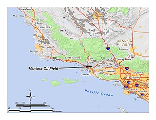
The Ventura Oil Field is a large and currently productive oil field in the hills immediately north of the city of Ventura in southern California in the United States. It is bisected by California State Route 33, the freeway connecting Ventura to Ojai, and is about eight miles (13 km) long by two across, with the long axis aligned east to west. Discovered in 1919, and with a cumulative production of just under a billion barrels of oil as of 2008, it is the tenth-largest producing oil field in California, retaining approximately 50 million barrels in reserve, and had 423 wells still producing. As of 2009 it was entirely operated by Aera Energy LLC.

<span class="mw-page-title-main">Salt Lake Oil Field</span> Oil field under Los Angeles, California, United States

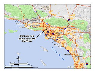
The Salt Lake Oil Field is an oil field underneath the city of Los Angeles, California. Discovered in 1902, and developed quickly in the following years, the Salt Lake field was once the most productive in California; over 50 million barrels of oil have been extracted from it, mostly in the first part of the twentieth century, although modest drilling and extraction from the field using an urban "drilling island" resumed in 1962. As of 2009, the only operator on the field was Plains Exploration & Production (PXP). The field is also notable as being the source, by long-term seepage of crude oil to the ground surface along the 6th Street Fault, of the famous La Brea Tar Pits.

<span class="mw-page-title-main">Long Beach Oil Field</span> Large oil field underneath cities of California, United States

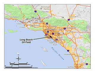
The Long Beach Oil Field is a large oil field underneath the cities of Long Beach and Signal Hill, California, in the United States. Discovered in 1921, the field was enormously productive in the 1920s, with hundreds of oil derricks covering Signal Hill and adjacent parts of Long Beach; largely due to the huge output of this field, the Los Angeles Basin produced one-fifth of the nation's oil supply during the early 1920s. In 1923 alone the field produced over 68 million barrels of oil, and in barrels produced by surface area, the field was the world's richest. The field is eighth-largest by cumulative production in California, and although now largely depleted, still officially retains around 5 million barrels of recoverable oil out of its original 950 million. 294 wells remained in operation as of the beginning of 2008, and in 2008 the field reported production of over 1.5 million barrels of oil. The field is currently run entirely by small independent oil companies, with the largest operator in 2009 being Signal Hill Petroleum, Inc.

<span class="mw-page-title-main">Rincon Oil Field</span> Large oil field on the central coast of southern California

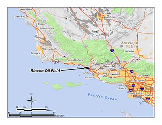
The Rincon Oil Field is a large oil field on the coast of southern California, about 10 miles (16 km) northwest of the city of Ventura, and about 20 miles (32 km) east-southeast of the city of Santa Barbara. It is the westernmost onshore field in a series of three fields which follow the Ventura Anticline, an east-west trending feature paralleling the Transverse Ranges. Discovered in 1927, the oil field is ranked 36th in California by size of recoverable oil reserves, and while mostly depleted – now having, by California Department of Conservation estimates, only about 2.5% of its original oil – it remains productive, with 77 wells active at the beginning of 2008. Oil produced in the field flows through the M-143 pipeline, which parallels U.S. Highway 101 southeast to the Ventura Pump Station, at which point it joins a Tosco pipeline which carries it to Los Angeles area refineries. As of 2009, the primary operators of the field were Occidental Petroleum for the onshore portion, and Greka Energy for the offshore portion. The offshore part of the field is operated mainly from Rincon Island.

<span class="mw-page-title-main">Dos Cuadras Offshore Oil Field</span>

The Dos Cuadras Offshore Oil Field is a large oil and gas field underneath the Santa Barbara Channel about eight miles southeast of Santa Barbara, California. Discovered in 1968, and with a cumulative production of over 260 million barrels of oil, it is the 24th-largest oil field within California and the adjacent waters. As it is in the Pacific Ocean outside of the 3-mile tidelands limit, it is a federally leased field, regulated by the U.S. Department of the Interior rather than the California Department of Conservation. It is entirely produced from four drilling and production platforms in the channel, which as of 2009 were operated by Dos Cuadras Offshore Resources (DCOR), LLC, a private firm based in Ventura. A blowout near one of these platforms – Unocal's Platform A – was responsible for the 1969 Santa Barbara oil spill that was formative for the modern environmental movement, and spurred the passage of the National Environmental Policy Act.

<span class="mw-page-title-main">Lompoc Oil Field</span> Oil field in California, United States

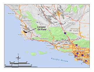
The Lompoc Oil Field is a large oil field in the Purisima Hills north of Lompoc, California, in Santa Barbara County. Discovered in 1903, two years after the discovery of the Orcutt Oil Field in the Solomon Hills, it is one of the oldest oil fields in northern Santa Barbara County, and one of the closest to exhaustion, reporting only 1.7 million barrels (270,000 m3) of recoverable oil remaining out of its original 50 million barrels (7,900,000 m3) as of the end of 2008. Its sole operator is Sentinel Peak Resources, who acquired it from Freeport-McMoRan. In 2009, the proposed decommissioning and habitat restoration of the 3,700-acre (15 km2) field was part of a controversial and so-far unsuccessful deal between Plains, several environmental groups, Santa Barbara County, and the State of California, to allow Plains to carry out new offshore oil drilling on the Tranquillon Ridge, in the Pacific Ocean about twenty miles (32 km) southwest of the Lompoc field.

<span class="mw-page-title-main">Brea-Olinda Oil Field</span> Oil field in Orange and Los Angeles Counties, California, United States

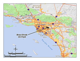
The Brea-Olinda Oil Field is a large oil field in northern Orange County and Los Angeles County, California, along the southern edge of the Puente Hills, about four miles (6 km) northeast of Fullerton, and adjacent to the city of Brea. Discovered in 1880, the field is the sixteenth largest in California by cumulative production, and was the first of California's largest 50 oil fields to be found. It has produced over 412 million barrels of oil in the 130 years since it was first drilled, and retains approximately 19 million barrels in reserve recoverable with current technology. As of the beginning of 2009, 475 wells remained active on the field, operated by several independent oil companies, including Linn Energy, BreitBurn Energy Partners L.P., Cooper & Brain, and Thompson Energy.

<span class="mw-page-title-main">Oxnard Oil Field</span> Oil field in Oxnard, California, United States

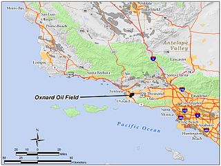
The Oxnard Oil Field is a large and productive oil field in and adjacent to the city of Oxnard, in Ventura County, California in the United States. Its conventional oil reserves are close to exhaustion, with only an estimated one percent of the original oil recoverable with current technology remaining: 434,000 barrels (69,000 m3) out of an original 43.5 million. However, the reservoir includes an enormous deposit of tar sands, ultra-heavy oil classed as an unconventional petroleum reserve, and potentially containing 400 million barrels (64,000,000 m3) of oil equivalent, should it become economically feasible to extract. Present operators on the field include Tri-Valley Oil & Gas Co., Anterra Energy Services, Inc., Chase Production Co., and Occidental Petroleum through its Vintage Production subsidiary. As of the beginning of 2009, there were 34 active wells on the field.

<span class="mw-page-title-main">Saticoy Oil Field</span> Oil and gas field in Ventura County, California, United States

The Saticoy Oil Field is an oil and gas field in Ventura County, California, in the United States. The field is a long narrow band paralleling the Santa Clara River near the town of Saticoy. Discovered in 1955, it is one of the smaller but productive fields found in the region after most of the large fields had already been operational for decades. At the beginning of 2009 it still contained an estimated 387,000 barrels (61,500 m3) of recoverable oil out of its original 23.5 million, and had 15 wells remaining in operation. Vintage Production, a subsidiary of Occidental Petroleum, was the primary operator on the field as of 2009.

<span class="mw-page-title-main">South Mountain Oil Field</span> Oil field adjacent to Santa Paula, California, United States

The South Mountain Oil Field is a large and productive oil field in Ventura County, California, in the United States, in and adjacent to the city of Santa Paula. Discovered in 1916, and having a cumulative production of over 158 million barrels (25,100,000 m3) of oil, it is the 37th largest oil field in California and the second largest in Ventura County. As of the beginning of 2009, it retains 316 active wells, and has an estimated 1.4 million barrels (220,000 m3) of oil remaining recoverable with current technology. Vintage Production, a subsidiary of Occidental Petroleum, was the largest operator as of 2009.

<span class="mw-page-title-main">Russell Ranch Oil Field</span>

The Russell Ranch Oil Field is an oil and gas field in the Cuyama Valley of northern Santa Barbara and southern San Luis Obispo Counties, California, in the United States. Discovered in 1948, and reaching peak production in 1950, it has produced over 68 million barrels (10,800,000 m3) of oil in its lifetime; with only an estimated 216,000 barrels (34,300 m3) of recoverable oil remaining, and having produced around 66,000 in 2008, it is considered to be close to exhaustion. The primary operator on the field as of 2010 is E&B Natural Resources, which also runs the nearby South Cuyama Oil Field.

<span class="mw-page-title-main">Guijarral Hills Oil Field</span> Formerly-productive oil and gas field near Coalinga, California, United States

The Guijarral Hills Oil Field is a formerly-productive oil and gas field near Coalinga on the western side of the Central Valley in central California in the United States. Discovered in 1948, and having produced 5.4 million barrels (860,000 m3) of oil during its peak year in 1950, it now has but one active oil well producing a little over a barrel of oil a day, and is very near to exhaustion, with only 343,000 recoverable barrels of oil remaining throughout its 2,515-acre (10.18 km2) extent according to the official California State Department of Conservation estimate. As of 2010, the only active operator was Longview Production Company.

<span class="mw-page-title-main">Carpinteria Offshore Oil Field</span>

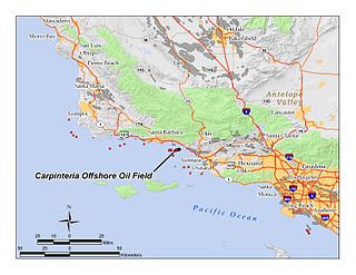
The Carpinteria Offshore Oil Field is an oil and gas field in Santa Barbara Channel, south of the city of Carpinteria in southern California in the United States. Discovered in 1964, and reaching peak production in 1969, it has produced over 106 million barrels of oil in its lifetime, and retains approximately 2 million barrels in reserve recoverable with present technology, according to the California State Department of Natural Resources. Currently the field is produced from three drilling platforms four to five miles offshore, within Federal waters outside of the tidelands zone. Two of the platforms are operated by Pacific Operators Offshore LLC (PACOPS), the operating arm of Carpinteria-based Carone Petroleum; the other platform is operated by Dos Cuadras Offshore Resources (DCOR). The Carpinteria field is the 50th largest field in California by total original oil in place, as of the end of 2008.

<span class="mw-page-title-main">Edison Oil Field</span> Oil field in Kern County, California

The Edison Oil Field is a large oil field in Kern County, California, in the United States, in the southeastern part of the San Joaquin Valley and adjacent foothills east-southeast of Bakersfield. The field has a total productive area of over 8,000 acres (32 km2), most of which is intermingled with agricultural land uses; oil pumps and storage tanks are surrounded with row crops and orchards in much of the field's extent. Discovered in 1928, and with a cumulative production of 149 million barrels (23,700,000 m3) of oil as of 2008, and having over 6 million barrels (950,000 m3) in reserve, it is ranked 38th among California's oil fields by total ultimate recovery. It is a mature field in decline, and is run entirely by small independent operators. As of 2008, there were 40 different oil companies active on the field, one of the most in the state for a single field. 914 wells remained active on the field, averaging only two barrels of oil per well per day from the dwindling reservoirs.

<span class="mw-page-title-main">Los Angeles City Oil Field</span> Oil field in Los Angeles, California

The Los Angeles City Oil Field is a large oil field north of Downtown Los Angeles. Long and narrow, it extends from immediately south of Dodger Stadium west to Vermont Avenue, encompassing an area of about four miles long by a quarter-mile across. Its former productive area amounts to 780 acres (3.2 km2).

<span class="mw-page-title-main">Cat Canyon Oil Field</span>

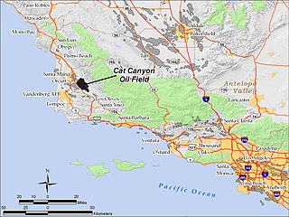
The Cat Canyon Oil Field is a large oil field in the Solomon Hills of central Santa Barbara County, California, about 10 miles southeast of Santa Maria. It is the largest oil field in Santa Barbara County, and as of 2010 is the 20th-largest in California by cumulative production.

<span class="mw-page-title-main">Inglewood Oil Field</span> Oil drilling operation in California, USA

The Inglewood Oil Field in Los Angeles County, California, is the 18th-largest oil field in the state and the second-most productive in the Los Angeles Basin. Discovered in 1924 and in continuous production ever since, in 2012 it produced approximately 2.8 million barrels of oil from some five hundred wells. Since 1924 it has produced almost 400 million barrels, and the California Department of Oil, Gas and Geothermal Resources (DOGGR) has estimated that there are about 30 million barrels remaining in the field's one thousand acres, recoverable with present technology.

<span class="mw-page-title-main">Honor Rancho Oil Field</span> Oil and natural gas field adjacent to Santa Clarita, California, United States

The Honor Rancho Oil Field is an approximately 600-acre oil field and natural gas storage facility in Los Angeles County, California, on the northern border of the Valencia neighborhood of Santa Clarita, near the junction of Interstate 5 and westbound California State Route 126. Discovered in 1950 and quickly developed, the field's oil production peaked in the 1950s, but remains productive in 2016. In 1975 Southern California Gas Company (SoCalGas), the gas utility serving Southern California, began using one of its depleted oil producing zones, the Wayside 13 zone, as a gas storage reservoir, and it became the second-largest in their inventory after the Aliso Canyon gas storage facility. The field shares part of its extent with the Peter J. Pitchess Detention Center, which includes a maximum-security prison.

References

34°03′23″N118°23′22″W / 34.0563°N 118.3894°W / 34.0563; -118.3894