
North Cascades National Park is an American national park in the state of Washington. At more than 500,000 acres (200,000 ha), it is the largest of the three National Park Service units that comprise the North Cascades National Park Complex. North Cascades National Park consists of a northern and southern section, bisected by the Skagit River that flows through the reservoirs of Ross Lake National Recreation Area. Lake Chelan National Recreation Area lies on the southern border of the south unit of the park. In addition to the two national recreation areas, other protected lands including several national forests and wilderness areas, as well as Canadian provincial parks in British Columbia, nearly surround the park. North Cascades National Park features the rugged mountain peaks of the North Cascades Range, the most expansive glacial system in the contiguous United States, the headwaters of numerous waterways, and vast forests with the highest degree of flora biodiversity of any American national park.
The Pacific Crest Trail (PCT), officially designated as the Pacific Crest National Scenic Trail, is a long-distance hiking and equestrian trail closely aligned with the highest portion of the Cascade and Sierra Nevada mountain ranges, which lie 100 to 150 miles east of the U.S. Pacific coast. The trail's southern terminus is next to the Mexico–United States border, just south of Campo, California, and its northern terminus is on the Canada–US border, upon which it continues unofficially to the Windy Joe Trail within Manning Park in British Columbia; it passes through the states of California, Oregon, and Washington.
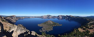
Crater Lake National Park is an American national park located in southern Oregon. Established in 1902, Crater Lake is the fifth-oldest national park in the United States and the only national park in Oregon. The park encompasses the caldera of Crater Lake, a remnant of Mount Mazama, a destroyed volcano, and the surrounding hills and forests.

Cascade Pass is a 5,392-foot (1,643 m) mountain pass over the northern Cascade Range, east of Marblemount, Washington, U.S.

The Stehekin River is a river located in Washington state in the Pacific Northwest of the United States. It is the main river flowing into Lake Chelan. Miners arrived in Stehekin River Valley in the late 19th century. They were followed by homesteaders in the early 20th century. Today, the Stehekin River Valley is still a remote area that can only be reached by way of a 55-mile boat ride up Lake Chelan.
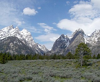
Cascade Canyon is located in Grand Teton National Park, in the U.S. state of Wyoming. The canyon was formed by glaciers which retreated at the end of the last glacial maximum approximately 15,000 years ago. Today, Cascade Canyon has numerous polished glacial erratics, hanging cirques and a U-shape as evidences that demonstrate that glaciers once filled the canyon to a depth of at least 2,000 feet (610 m). Rock debris that was transported out of the canyon by glacial motion formed moraines which now impound the waters of Jenny Lake which is located at the base of the canyon. Cascade Creek now flows where the glaciers once did and the numerous waterfalls, such as the 100-foot (30 m) tall Hidden Falls, found within the gorge are popular destinations with tourists.

Sahale Mountain is a jagged, glaciated mountain, in North Cascades National Park, in northern Washington state. The summit of Sahale Mountain is referred to as Sahale Peak. It is 0.3 miles (0.48 km) south of its higher neighbor, Boston Peak, and the saddle between the two is 80 feet (24 m) lower than Sahale's summit. Quien Sabe Glacier is to the west of the ridge between the two peaks while Davenport Glacier is in a cirque east of this ridge and above Horseshoe Basin. Sahale Glacier is south of the summit and east of Sahale Arm, a ridge that extends southwest from Sahale to Cascade Pass. The name Sahale may originate from a Northwest Native American word meaning "high place," "falcon," or "sacred."

Buckner Mountain is a tall peak in the North Cascades of Washington state and in the Stephen Mather Wilderness of North Cascades National Park. At 9,114 feet (2,778 m) in elevation it is the highest in Skagit County and one of about ten of Washington's non-volcanic peaks above 9,000 feet high. It is ranked as the 14th highest peak in the state, and the third highest peak in North Cascades National Park.

Boston Peak is a tall peak in the North Cascades in the U.S. state of Washington and within North Cascades National Park. At 8,894 feet (2,711 m) in elevation it is the 26th highest peak in Washington. Its nearest higher neighbor is Buckner Mountain, 1.66 miles (2.67 km) to the east.

Albert Hale Sylvester was a pioneer surveyor, explorer, and forest supervisor in the Cascade Range of the U.S. state of Washington. He was a topographer for the United States Geological Survey (USGS) in the Snoqualmie Ranger District between 1897 and 1907. Then, from 1908 to 1931, he served the United States Forest Service as the first forest supervisor of Wenatchee National Forest. His work involved the first detailed surveying and mapping of large portions of the Cascade Range in Washington, over the course of which he gave names to over 1,000 natural features. The surveying work often required placing cairns and other survey targets on top of mountains. He made the first ascents of a number of mountains in Washington. Over the course of his career he explored areas previously unknown to non-indigenous people. One such area, which Sylvester discovered, explored, and named, is The Enchantments. In 1944, while leading a party of friends to one of his favorite parts of the mountains, Sylvester was mortally wounded when his horse panicked and lost his footing on a steep and rocky slope.

Falls Creek, also known as the Falls River, is a tributary of the Tuolumne River in Yosemite National Park, California, United States. The creek begins at the northern boundary of the national park and flows 24 miles (39 km) to empty into the Tuolumne at Hetch Hetchy Reservoir, dropping over two well-known waterfalls. The Pacific Crest Trail and other national park trails follow the creek for much of its course.

The Cascade Canyon Trail is a 13.6-mile (21.9 km) round-trip long hiking trail in Grand Teton National Park in the U.S. state of Wyoming.

Davenport Glacier is located in a cirque to the southeast of Boston Peak, North Cascades National Park in the U.S. state of Washington. The glacier is approximately .20 mi (0.32 km) in length resting at between 8,000 and 7,500 ft. The glacier is also northeast of Sahale Mountain and separated from the much larger Boston Glacier to the north by an arête called "Ripsaw Ridge".

Dagger Lake is located in North Cascades National Park, in the U. S. state of Washington. Dagger Lake is accessible via the Twisp Pass Trail and the lake is 7.6 mi (12.2 km) from the North Cascades Highway or 4.7 mi (7.6 km) from the Twisp River Road trailhead in Wenatchee National Forest.

Trapper Lake is located in North Cascades National Park, in the U. S. state of Washington. Trapper Lake is situated just northeast of Trapper Mountain and is not on a designated trail. The lake is accessible after a steep climb from the Upper Stehekin River Trail. The lake is fed by meltwater from the S Glacier on Hurry-up Peak, as well as runoff from Magic Mountain and Pelton Peak.
Kettling Lake is located in North Cascades National Park, in the U. S. state of Washington. The lake is not accessible via any designated trails but is only about 1 mi (1.6 km) south of the Pacific Crest Trail and the Twisp Pass Trail junction.

Hidden Lake is located immediately east of Hidden Lake Peaks in North Cascades National Park, in the U. S. state of Washington. Hidden Lake is off designated trails but can reached by way a trailhead off the Cascade River Road from Snoqualmie National Forest. The distance from the trailhead to the lake is 4.5 mi (7.2 km) one way to the overlook and another 0.8 mi (1.3 km) rock scramble through a boulder field to the lakeshore.

Klawatti Lake is located in North Cascades National Park, in the U. S. state of Washington. Klawatti Lake is in a remote section of the park and well off any designated trails. Klawatti Lake was formed by the retreat of Klawatti Glacier and North Klawatti Glacier in the mid-1900s. During warmer months, melt from both the North Klawatti Glacier and Klawatti Glacier flows into Klawatti Lake. Klawatti Peak is 1 mi (1.6 km) west of the lake.
Monogram Lake is located in North Cascades National Park, in the U. S. state of Washington. Monogram Lake can be reached by trail from Snoqualmie National Forest. The distance from the trailhead to the lake is 5 mi (8.0 km) one way and is considered strenuous since it requires an altitude gain of 4,040 ft (1,230 m). The lake is situated two miles east of Lookout Mountain, and 1.5 mile south of Little Devil Peak. The lake drains to the Cascade River via Monogram Creek.


