
The Djibouti Armed Forces are the military forces of Djibouti. They consist of the Djiboutian National Army and its sub-branches the Djiboutian Air Force and Djiboutian Navy. As of 2018, the Djibouti Armed Forces consists of 20,470 ground troops, which are divided into several regiments and battalions garrisoned in various areas throughout the country. The Djibouti Armed Forces are an important player in the Bab-el-Mandeb and Red Sea.
Eritrea is an ancient name, associated in the past with its Greek form Erythraia, Ἐρυθραία, and its derived Latin form Erythræa. This name relates to that of the Red Sea, then called the Erythræan Sea, from the Greek for "red", ἐρυθρός, erythros. But earlier Eritrea was called Mdre Bahri. The Italians created the colony of Eritrea in the 19th century around Asmara and named it with its current name. After World War II, Eritrea annexed to Ethiopia. Following the communist Ethiopian government's defeat in 1991 by the coalition created by armed groups notably the EPLF, Eritrea declared its independence. Eritrea officially celebrated its 1st anniversary of independence on May 24, 1993.

Eritrea is located in the Horn of Africa and is bordered on the northeast and east by the Red Sea, on the west and northwest by Sudan, on the south by Ethiopia, and on the southeast by Djibouti. The country has a high central plateau that varies from 1,800 to 3,000 meters (5,906–9,843 ft) above sea level. A coastal plain, western lowlands, and some 350 islands comprise the remainder of Eritrea's land mass.

Italian East Africa was an Italian colony in the Horn of Africa. It was formed in 1936 after the Second Italo-Ethiopian War through the merger of Italian Somaliland, Italian Eritrea, and the newly occupied Ethiopian Empire.

The Bab-el-Mandeb, the Gate of Grief or the Gate of Tears, is a strait between Yemen on the Arabian Peninsula and Djibouti and Eritrea in the Horn of Africa. It connects the Red Sea to the Gulf of Aden and by extension the Indian Ocean.

The Horn of Africa (HoA), also known as the Somali Peninsula, is a large peninsula and geopolitical region in East Africa. Located on the easternmost part of the African mainland, it is the fourth largest peninsula in the world. It is composed of Somalia, Djibouti, Ethiopia, and Eritrea. Although not common, broader definitions include parts or all of Kenya and Sudan. It has been described as a region of geopolitical and strategic importance, since it is situated along the southern boundary of the Red Sea; extending hundreds of kilometres into the Gulf of Aden, Guardafui Channel, and Indian Ocean, it also shares a maritime border with the Arabian Peninsula.

Isaias Afwerki is an Eritrean politician and partisan who has been the first and only president of Eritrea since 1993. In addition to being president, Isaias has been the chairman of Eritrea's sole legal political party, the People's Front for Democracy and Justice (PFDJ).

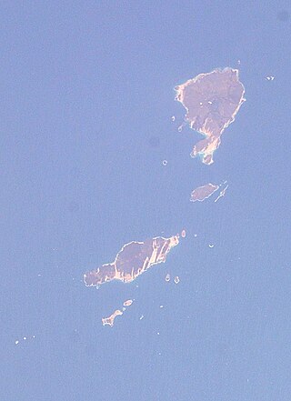
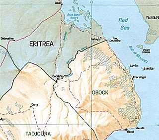
The Obock Region is a region in northern Djibouti. It has a land area of 4,700 square kilometres, and had a population of 37,856 in 2009. It lies along the Red Sea, Bab-el-Mandeb, Gulf of Aden, Gulf of Tadjoura and includes the Seven Brothers, Doumeira Islands and the coastal city of Obock. It lies along a portion of the national border with Eritrea. In total area, it is larger than Cape Verde and smaller than Trinidad and Tobago. The topography of the region has highland and coastal plains.
The Hanish Islands is an archipelago in the Red Sea consisting of a trio of major islands at the centre of an array of smaller islets and rocks. The three major islands are the northern Zuqar Island, the southern Great Anish, and the significantly smaller Little Anish in between. The archipelago is largely under the control of Yemen, with only several small south-western rocks and islets granted to Eritrea following the Hanish Islands conflict in 1994–1995.

Mousa Ali is a 2,028 metres (6,654 ft) stratovolcano located on the tri-point of Ethiopia, Eritrea and Djibouti. The volcano is the highest point in Djibouti. The volcano's summit is truncated by a caldera, which contains rhyolitic lava domes and lava flows. The last known eruption occurred before the Holocene era.

Djibouti, officially the Republic of Djibouti, is a country in the Horn of Africa, bordered by Somalia to the south, Ethiopia to the southwest, Eritrea in the north, and the Red Sea and the Gulf of Aden to the east. The country has an area of 23,200 km2 (8,958 sq mi).
The Djiboutian–Eritrean border conflict was a border conflict between the forces of Djibouti and Eritrea occurred between June 10 and June 13, 2008. It was triggered by tension which began on April 16, 2008, when Djibouti reported that Eritrean armed forces had penetrated into Djibouti and dug trenches on both sides of the border. The crisis deepened when armed clashes broke out between the two armed forces in the border area on June 10, 2008. During the conflict, France provided logistical, medical and intelligence support to Djibouti, but did not participate in direct combat.
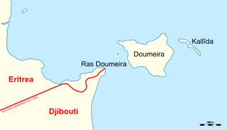
Ras Doumeira is a geographic cape that extends into the Red Sea, towards the Doumeira Islands. The area is in the north of Djibouti and also border Eritrea, and was the subject of the 2008 border dispute between the two countries. In September 2018 ten years after the conflict, it was announced that Djibouti and Eritrea agreed to normalize their relations.
Eritrea is one of the three non-member states of the Arab League which adopted Arabic as a working language. Eritrea chooses not to be a part of the Arab League.

Djibouti–Eritrea relations refers to the current and historical relationship between neighboring states Djibouti and Eritrea.
United Nations Security Council Resolution 1862 was unanimously adopted on 14 January 2009.
The military history of Djibouti encompasses the major conflicts involving the historic empires and sultanates in the territory of present-day Djibouti, through to modern times. It also covers the martial traditions and hardware employed by Djiboutian armies and their opponents.

The Eritrean–Ethiopian border conflict was a violent standoff and a proxy conflict between Eritrea and Ethiopia lasting from 1998 to 2018. It consisted of a series of incidents along the then-disputed border; including the Eritrean–Ethiopian War of 1998–2000 and the subsequent Second Afar insurgency. It included multiple clashes with numerous casualties, including the Battle of Tsorona in 2016. Ethiopia stated in 2018 that it would cede Badme to Eritrea. This led to the Eritrea–Ethiopia summit on 9 July 2018, where an agreement was signed which demarcated the border and agreed a resumption of diplomatic relations.
Beginning with the Kingdom of Aksum, Ethiopia's territory evolved significantly through conquest of the lands surrounding it. Strong Aksumite trading partnerships with other world powers gave prominence to its territorial expansion. In 330, Aksum besieged the Nubian city of Meroë, marking the beginning of its great expansion. It finally declined after the rise of Islamic dominion in South Arabia, and it ultimately collapsed in the 10th century.

During World War I, Ethiopia briefly forged an alliance with the Allied Powers, following Italy's entry into the war in 1915. In June 1916, a dynastic conflict emerged when the uncrowned Emperor, Lij Iyasu, was alleged to have converted to Islam under the influence of the Ottoman Empire, which led him to be charged with apostasy. As a result, then-regent Ras Tafari Mekonnen, later known as Emperor Haile Selassie, orchestrated a coup d'état in September, deposing Lij Iyasu and installing Empress Zewditu on the throne. Throughout the war, Empress Zewditu maintained a stance of neutrality.

