
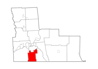
Broome County is a county in the U.S. state of New York. As of the 2020 United States census, the county had a population of 198,683. Its county seat is Binghamton. The county was named for John Broome, the state's lieutenant governor when Broome County was created. The county is part of the Southern Tier region of the state.

Binghamton is a city in the U.S. state of New York, and serves as the county seat of Broome County. Surrounded by rolling hills, it lies in the state's Southern Tier region near the Pennsylvania border, in a bowl-shaped valley at the confluence of the Susquehanna and Chenango Rivers. Binghamton is the principal city and cultural center of the Binghamton metropolitan area, home to a quarter million people. The city's population, according to the 2020 census, is 47,969.

Port Dickinson is a village in Broome County, New York, United States. The population was 1,641 at the 2010 census. It is part of the Binghamton Metropolitan Statistical Area.

Vestal is a town within Broome County in the Southern Tier of New York, United States, and lies between the Susquehanna River and the Pennsylvania border. As of the 2020 census, the population was 29,110. Vestal is on the southern border of the county, and serves as a western suburb of the city of Binghamton. The town is home to the main campus of Binghamton University.
Binghamton is a town in Broome County, New York, United States. The population was 4,623 at the 2020 census. The town is named after an early developer, William Bingham.

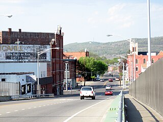
Norwich is a city and county seat of Chenango County, New York, United States. Surrounded on all sides by the Town of Norwich, the city's name is taken from Norwich, England. Its population was 7,190 at the 2010 census.

The Chenango River is a 90-mile-long (140 km) tributary of the Susquehanna River in central New York in the United States. It drains a dissected plateau area in upstate New York at the northern end of the Susquehanna watershed.
The Chenango Canal was a towpath canal in central New York in the United States which linked the Susquehanna River to the Erie Canal. Built and operated in the mid-19th century, it was 97 miles long and for much of its course followed the Chenango River, along New York State Route 12 from Binghamton on the south end to Utica on the north. It operated from 1834 to 1878 and provided a significant link in the water transportation system of the northeastern U.S. until supplanted by the region's developing railroad network.

Interstate 88 (I-88) is an Interstate Highway located entirely within the US state of New York. Nominally signed as an east–west road as it has an even number, it extends for 117.75 miles (189.50 km) in a northeast–southwest direction from an interchange with I-81 north of the city of Binghamton to an interchange with the New York State Thruway (I-90) west of Schenectady. The freeway serves as an important connector route from the Capital District to Binghamton, Elmira, and Scranton, Pennsylvania. I-88 closely parallels NY 7, which was once the main route through the area.

New York State Route 7 (NY 7) is a 180.30-mile-long (290.16 km) state highway in New York in the United States. The highway runs from the Pennsylvania state line south of Binghamton in Broome County, New York, to the Vermont state line east of Hoosick in Rensselaer County, where it continues as Vermont Route 9. Most of the road runs along the Susquehanna Valley, closely paralleling Interstate 88 (I-88) throughout that road's length. Portions of the highway route near the cities of Binghamton, Schenectady, and Troy date back to the early 19th century.

New York State Route 41 (NY 41) is a north–south state highway in Central New York in the United States. The southern terminus of the route is at an interchange with NY 17 in the town of Sanford in Broome County, New York. Its northern terminus is at an intersection with U.S. Route 20 (US 20) in the village of Skaneateles. The route is almost 100 miles (161 km) long and passes through Broome, Chenango, Cortland, and Onondaga counties. NY 41 was assigned as part of the 1930 renumbering of state highways in New York, replacing New York State Route 70 from Homer to Skaneateles. The route initially extended as far north as Jordan; however, NY 41 was cut back to its current northern terminus c. 1933.

New York State Route 79 (NY 79) is a 93.18-mile-long (149.96 km) east–west state highway in the Southern Tier of New York, in the United States. The western terminus of the route is at the intersection with NY 414 near the southern end of Seneca Lake just northeast of Watkins Glen. Its eastern terminus is at the Pennsylvania state line in the town of Windsor in Broome County, where it connects to Pennsylvania Route 92 (PA 92). NY 79 passes through three regions; it starts in the Finger Lakes region, runs through Central New York and ends on the western fringes of the Catskills. The route is signed east–west, but from Whitney Point to the state line it runs in a north–south orientation and is signed north–south a few miles south of Center Village, a hamlet that is a few miles south of Harpursville.

New York State Route 434 (NY 434) is a state highway located in the Southern Tier of New York in the United States. The route extends for 20.89 miles (33.62 km) from an intersection with NY 96 in the village of Owego to an intersection with U.S. Route 11 (US 11) in the city of Binghamton. In between, NY 434 passes through the towns of Owego and Vestal. The portion of NY 434 from the Tioga–Broome county line to downtown Binghamton is known as the Vestal Parkway.

New York State Route 17C (NY 17C) is a state highway in the Southern Tier of New York in the United States. Its western terminus is at an intersection with NY 34 in Waverly, Tioga County while its eastern terminus is at an intersection with U.S. Route 11 (US 11) in Binghamton, Broome County. The route runs concurrently with NY 96 for a block in Owego and for a few blocks with NY 26 in Endicott.
The Binghamton Metropolitan Statistical Area, also called Greater Binghamton or the Triple Cities, is a region of southern Upstate New York in the Northeastern United States, anchored by Binghamton. The MSA encompasses Broome and Tioga counties, which together had a population of 247,138 as of the 2020 census. From 1963 to 1983, the MSA also included neighboring Susquehanna County in Pennsylvania, part of which still falls in the Binghamton, NY–PA Urban Area. In addition to these three counties, the greater region includes parts of Delaware and Chenango counties in New York; portions of Cortland and Otsego counties in New York and Wayne County, Pennsylvania are sometimes considered part of the region as well. Using the definition of a 30-mile radius from Binghamton, the population as of the 2010 census is 317,331.

U.S. Route 11 (US 11) is a part of the United States Numbered Highway System that runs from New Orleans, Louisiana, to the Canada–United States border at Rouses Point, New York. In the state of New York, US 11 extends for 318.66 miles (512.83 km) from the Pennsylvania state line south of the Southern Tier city of Binghamton to the Canada–United States border at the North Country village of Rouses Point, where it becomes Route 223 upon entering Quebec. The portion of US 11 south of Watertown follows a mostly north–south alignment and is paralleled by Interstate 81 (I-81) while the part of the route north of Watertown follows a more east–west routing, parallel to but not directly on the St. Lawrence River.

Interstate 81 (I-81) is a part of the Interstate Highway System that runs from I-40 at Dandridge, Tennessee, to the Thousand Islands Bridge at Wellesley Island in New York, beyond which the short 2.7-mile (4.3 km) Ontario Highway 137 (Highway 137) links it to Highway 401. In the US state of New York, I-81 extends 183.60 miles (295.48 km) from the Pennsylvania state line southeast of Binghamton to the Canadian border at Wellesley Island northwest of Alexandria Bay. The freeway runs north–south through Central New York, serving the cities of Binghamton, Syracuse, and Watertown. It passes through the Thousand Islands in its final miles and crosses two bridges, both part of the series of bridges known as the Thousand Islands Bridge.

The West Side, as the name implies, is a neighborhood in the western section of the New York State city of Binghamton. It is primarily an urban residential neighborhood with retail along Main Street and pockets of industrial buildings along the train tracks.
The Brandywine Highway is a north–south expressway in the vicinity of the city of Binghamton, New York, in the United States. The highway is maintained by the New York State Department of Transportation and extends for 3.95 miles (6.36 km) through Downtown Binghamton and the neighboring village of Port Dickinson. The southern terminus of the highway is at New York State Route 434 (NY 434) in Binghamton and its northern terminus is at Interstate 88 (I-88) in Fenton just north of the Port Dickinson village line.
The North Side is a neighborhood in northern section of the New York State city of Binghamton. It is a mixed-use urban neighborhood with commercial and industrial businesses many times occupying sections of residential blocks.


